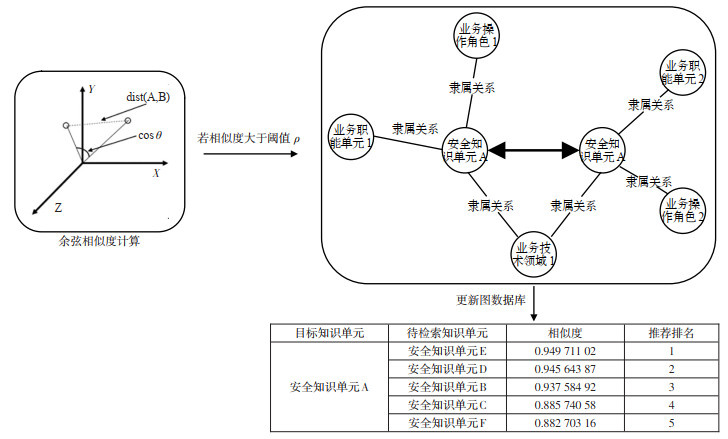
Current Issue

2025 Vol. 43, No. 3

Display Method:
2025, 43(3): .
Abstract(29) HTML (14) PDF(2)
Abstract:
Research Hotspots and Prospects of NSFC-Civil Aviation Joint Research Fund in Recent 20 Years
SUN Liang, ZOU Jianxin, HU Xinqiang
2025, 43(3): 1-9. doi: 10.3963/j.jssn.1674-4861.2025.03.001
Abstract(35) HTML (17) PDF(10)
Abstract:
The NSFC-Civil Aviation Joint Research Fund serves national strategic needs, focuses on fundamental research for civil aviation applications, promotes scientific and technological innovation, and supports industry development through its research outcomes. To systematically understand the topic evolution of the NSFC-Civil Aviation Joint Research Fund projects, a text mining method combining word frequency analysis and latent Dirichlet allocation (LDA) topic modeling is applied to analyze the topic selection guidelines and project approvals from 2004 to 2023. The study reveals the keyword characteristics of the guidelines, analyzes research hotspots and their evolutionary trends, and provides the research prospects of civil aviation. The results indicate that: ①The NSFC-Civil Aviation Joint Research Fund exhibits distinct phases and attracts diversified research forces. ②The guidelines are highly consistent with national policies and strategic development directions. Keywords such as civil aviation, airport, aircraft, safety, emergencies, and NextGen have frequently appeared in the guidelines over the past 20 years, while low-altitude operation may emerge as a new hotspot in future. ③The fund mainly focuses on 11 research topics, including aircraft airworthiness, airport construction and operation, air traffic management and optimization, aviation safety and risk management, emergencies and emergency management, green aviation, and so on. ④Four topics including aircraft airworthiness, airport construction and operation, air traffic management and optimization, and aviation safety and risk management have remained hot in the past 20 years. The research hotspots in civil aviation are shifting from traditional infrastructure construction and safety technology fields to emerging fields such as informatization, intelligence, and green development. The trend is also moving from single-discipline dominance to multidisciplinary integration. Looking ahead, the future NSFC-Civil Aviation Joint Research Fund is expected to focus on constructing a digital intelligence ecology, enhancing system-wide safety, and promoting green development. By fostering multifaceted synergistic cross-fertilization and developimg an autonomous knowledge system, it aims to drive the high-quality development of civil aviation.
A Knowledge Graph of Ship Collision Prevention and Control Based on Multi-source Heterogeneous Information
YU Hongchu, GUO Zheng, WEI Tianming, XU Lei, FANG Qinglong
2025, 43(3): 10-23. doi: 10.3963/j.jssn.1674-4861.2025.03.002
Abstract(42) HTML (13) PDF(8)
Abstract:
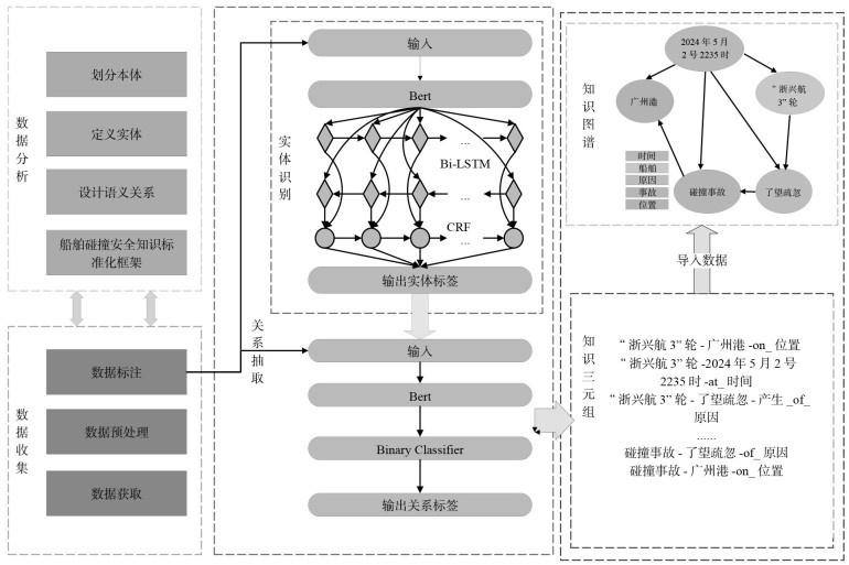
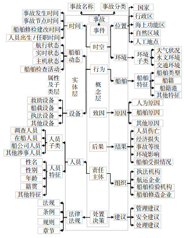
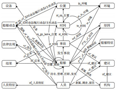
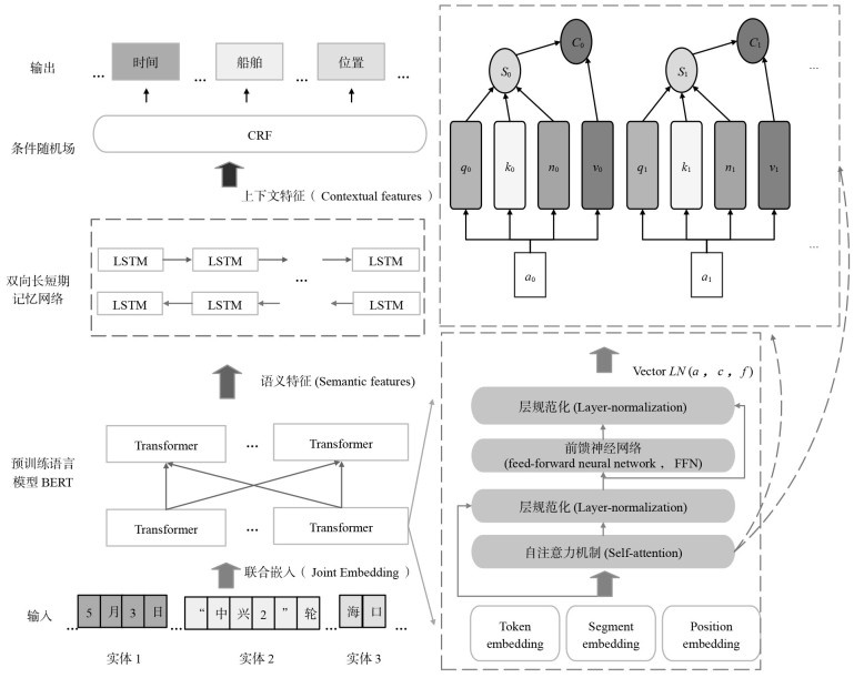
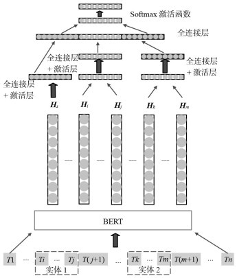
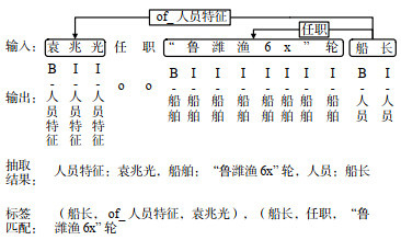
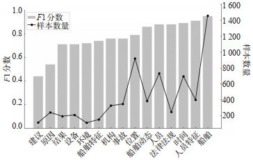
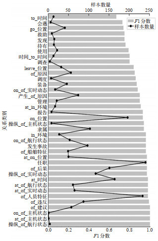
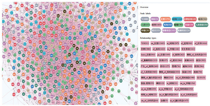
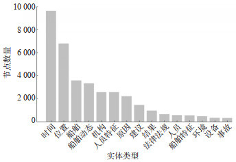
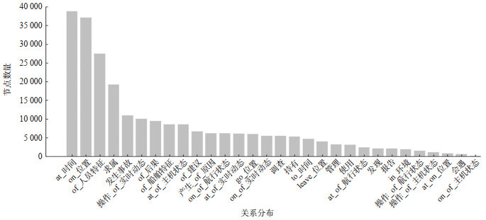
Traditional research on water transportation accidents mainly focuses on exploring the causative factors and corresponding complex relationship with various accidents, which is insufficient in reflecting the evolution of traffic accidents and the complicated interactions between elements including people, vessels, cargo, environment, administration, and information in the maritime system. To fill the gap, this paper proposes a methodology for developing a water transportation knowledge graph based on multi-source heterogeneous information and applies it to the accident prevention and control strategies development. A framework for ship collision knowledge is designed, considering the components of accidents, e.g., event, spatiotemporal ship behavior, maritime accidents causative factors, accidents consequences, corresponding responsibility roles, and disposal decision-making. A knowledge extraction model is employed to extract the maritime safety knowledge, which is based on Chinese Bidirectional Encoder Representations from Transformers Whole Word Masking and is named as Chinese-bert-wwm model. Thirdly, the SCPCKG (ship collision prevention and control knowledge graph) is developed based on the Neo4j database, which contains 35 784 entities from 15 entity types and 325 097 relationships from 39 relationship types. The scale of the SCPCKG is significantly larger than that of existing knowledge graphs in the field of water transportation, and the accuracy of automated knowledge extraction based on the proposed SCPCKG reaches 85%, which is higher than the existing models, such as Hidden Markov Models (HMMs) and Conditional Random Fields (CRFs). Specifically, the F1 -score value for identifying"ship", "person characteristics", "time", "person", and"laws"entities reaches 95%, 91%, 98%, 88%, and 88%, respectively; the F1 -score value of relationship extraction reaches 94%. The results show that the proposed Chinese-bert-wwm model can enhance the generalized capability of the knowledge extraction model by extracting the semantic features of ship collision accidents from the accident reports, and the proposed SCPCKG can be used for the knowledge representation of ship collision accidents and inversion of accidents for maritime administrators, improving the effectiveness of the water transportation management.
A Method of Full Section Surface High-speed Sensing for Track Safety Inspection
DING Jianlong, JIN Hui, LI Zhaoxin, CHENG Zhiquan, SONG Tianhao, XU Haoxuan
2025, 43(3): 24-32. doi: 10.3963/j.jssn.1674-4861.2025.03.003
Abstract(23) HTML (12) PDF(3)
Abstract:
Inspection of rail transit safety includes many elements. Methods based on a single image cannot perceive the details of the entire track section quickly. Multi-image stitching is greatly affected by the turning and swinging of the inspection vehicle, and the exposure conditions of different cameras result in significant brightness deviations, which reduces the accuracy of the identification of diseases. A full section surface sensing method for track inspection based on multiple line array images is proposed to address the above issues. A checkerboard calibration board is used to establish a rigid connection relationship between each camera, and the horizontal and vertical resolutions are adjusted to be equal. An invariant feature of tracks is established based on the edges of track surface and bottom to calculate the deviation of straight, curved, and swinging sections. Improved YOLO v10 algorithm is used to automatically extract the above feature. An improved histogram matching method is used to restore the overall brightness and achieve uniform transition at the joint of images based on the statistical characteristics of the forward direction and constrained by the two sides of the tracks with little brightness difference. Data collection is conducted at a certain section of Wuhan Metro and Wuhan Railway Bureau, with inspection vehicle running at speeds of 10, 40, 60, 80, and 120 km/h. The restoration method for image offset based on improved YOLO v10 reaches an average error of 11.21 pixels, with a precision rate of 95.20%, a recall rate of 93.58%, and an average accuracy of 84.03%, in which the recall rate has an increasing of 0.51%, and a pass rate of 99.43 % for 80 km. The mean difference between the overall image and the constrained image after brightness adjustment is 0.682, and the standard deviation is only 0.344, which are improved by 61.38% and 83.38% respectively compared to existing methods. The experimental results show that the proposed surface detail perception method for track safety inspection can obtain high-resolution images of the entire track section with a position error of less than 4.5 mm and a grayscale error of less than 1.71 under high-speed condition, greatly improving the efficiency of track safety inspection.
Deep Mining and Association Recommendation Method for Railway Safety Knowledge Based on Multimodal Information Fusion
GAO Li, YANG Nuohan, LI Qing, WANG Yongheng, YAN Han, ZHAO Ruhao, MA Xiaoping
2025, 43(3): 33-43. doi: 10.3963/j.jssn.1674-4861.2025.03.004
Abstract(34) HTML (10) PDF(3)
Abstract:
The rapid digital and intelligent transformation of railway information systems has created an urgent demand for fine-grained, explainable safety knowledge recommendations. To address the fragmentation of cross-modal associations and insufficient alignment with operational rules exhibited by traditional approaches, a framework integrating multimodal feature fusion with generative reasoning is investigated. A hierarchical railway safety knowledge graph is constructed, and topological features under business constraints are extracted via the Node2Vec algorithm. Simultaneously, a lightweight Transformer encoder (GTE) captured deep semantic embeddings of individual safety clauses. To balance contributions from graph and text features, a tunable weighting strategy is introduced, dynamically controlling the fusion ratio of text vectors and graph embeddings and applying a dual-constraint mechanism based on cosine similarity and predefined rules to generate candidate recommendations. A three-stage progressive retrieval architecture is designed to achieve precise multimodal alignment and suppress noise. Finally, the DeepSeek-R1 large language model served as the reasoning engine, with domain-specific prompting converting retrieved candidates into executable decision plans, thereby enhancing coherence and interpretability. Experiments on 27 safety documents from a railway operator, using a similarity threshold of 0.85 and a maximum of 10 recommendations per query, demonstrated a recommendation accuracy of 95% (an 8-percentage-point improvement over traditional methods) along with significant gains in contextual relevance and explainability. This investigation confirms the synergistic benefits of multimodal retrieval and generative reasoning, providing a robust technical foundation for evolving railway safety knowledge services from precise recommendation to intelligent decision support.
An Analysis and Identification Methods of Dangerous Driving Behavior Characteristics at Highway Tunnel Entrances and Exits
LIU Tangzhi, PAN Yihan, LIU Xingliang, LIU Yuanqiang, BAI Zhiyuan
2025, 43(3): 44-54. doi: 10.3963/j.jssn.1674-4861.2025.03.005
Abstract(30) HTML (12) PDF(7)
Abstract:
Dangerous driving behaviors frequently occur at highway tunnel entrances and exits, posing a high risk of traffic accidents. To address the challenge of ineffective driving risk assessment caused by the inability to continuously monitor trajectory data at tunnel transition zones, this study designs a radar-video fusion trajectory sampling system with a monitoring range covering 250 meters inside and outside the tunnel portal. A dangerous driving behavior identification method based on feature parameter optimization is proposed. Based on trajectory data at tunnel entrances and exits, the characteristics of driving behavior in these zones are analyzed, and four types of dangerous driving behaviors including sudden acceleration or deceleration, serpentine driving, high-risk car-following, and aggressive lane-changing, are selected to construct a dangerous driving behavior spectrum. A risk quantification method is used to measure indicators of the four dangerous driving behaviors, and the interquartile range (IQR) method is applied to set threshold boundaries for the feature parameters. Based on these thresholds, driving risk points exceeding the boundary values are identified and visualized, and the spatial distribution characteristics of the four types of dangerous driving behaviors are preliminarily obtained. To balance the dataset, random oversampling (ROS), synthetic minority oversampling technique (SMOTE), and adaptive synthetic sampling (ADASYN) are used for sample preprocessing. Three ensemble learning methods: eXtreme gradient boosting (XGBoost), light gradient boosting machine (LGBM), and adaptive boosting (AdaBoost), are orthogonally combined with the above sampling methods to construct balanced-ensemble coupled algorithms. A total of 12 dangerous driving behavior recognition models are established, including those based on single ensemble learning algorithms and orthogonally combined balanced-ensemble algorithms. The performance differences among various models are validated through model testing to determine the optimal recognition model. Spearman correlation analysis is employed to identify key parameters and enhance model recognition performance. The research results indicate that due to the complex traffic environment and fluctuating driver behaviors, highway tunnel entrances and exits are high-risk zones for traffic accidents. Among the three single-modality ensemble models and nine balanced-ensemble coupled models evaluated, the SMOTE-LGBM coupled model based on sample optimization demonstrates superior recognition performance for dangerous driving behaviors in tunnel transition zones. Its precision, F-score, and AUC values range from 91.2% to 91.4%, 0.913 to 0.918, and 0.907 to 0.912, respectively, outperforming other algorithms and maintaining consistently high levels.
An Optimization Method for Joint Control of Merging Zones in Urban Tunnels of Considerable Length
LYU Nengchao, HAO Yilin, YANG Ge, XIE Tian
2025, 43(3): 55-65. doi: 10.3963/j.jssn.1674-4861.2025.03.006
Abstract(25) HTML (17) PDF(0)
Abstract:
To address traffic congestion at merging zones in urban tunnels of considerable length, an optimization method for joint control that integrates variable speed limits in mainlines and signal control at ramps is proposed. A four-level control strategy is developed based on the combination of different traffic states in merging bottleneck area and downstream section. The traditional meta network (METANET) model is modified by comprehensively considering ramp inflow, speed differences among sections, and driver compliance. Meanwhile, the classical ALINEA algorithm is extended by introducing a control mechanism for queue capacity at ramps, enabling the integration of variable speed limits and ramp signal control. On this basis, a model predictive control approach is employed to optimize speed limits and ramp signal timings under different traffic states. Using the VISSIM simulation platform, the scenario of Lianghu Tunnel in Wuhan is developed, which allows to acquire and control the traffic parameters in real-time through the COM interface and secondary development with Python. Various control strategies are compared, including dynamic variable speed limits, ramp signal control, and joint control. Simulation results show that: ①Compared to the situation with no control, the proposed joint control strategy reduces travel time in the bottleneck area by 17.7% and decreases the average delay time per vehicle by 62.96%. ②Compared to single control strategy, the joint control strategy significantly improves average speed and stability of traffic flow, with especially notable effects under heavy congestion conditions. ③Under the joint control strategy, the minimum average speed at road sections increases by 20.38%, the duration of slow traffic in the bottleneck area and at the downstream section decreases by 22.2%, and both the spatial scope and duration of low-speed regions are significantly reduced with a substantial decrease in speed fluctuations. When facing various complex traffic flow conditions, the joint control strategy demonstrates good dynamic adaptability, automatically adjusting the control strength of the mainline and ramp according to the flow structure, thus achieving a rational distribution of traffic load in the bottleneck area.
A Study on the Influence of Side Wall Effect of Urban Tunnel on Driver's Eye Movement and Behavior Characteristics
YI Xuanxuan, PAN Ting, HE Shiming
2025, 43(3): 66-73. doi: 10.3963/j.jssn.1674-4861.2025.03.007
Abstract(22) HTML (8) PDF(5)
Abstract:
To investigate the influence of tunnel sidewalls on drivers' visual characteristics and driving behavior across different lanes in a three-lane urban tunnel, a field driving experiment was conducted involving 25 drivers. Both visual and driving behavior indicators were collected. Visual indicators included gaze distribution ratios and gaze entropy values, reflecting drivers' attention allocation strategies. Driving behavior indicators, such as lateral offset and lateral acceleration, were used to evaluate drivers' lateral vehicle control ability. The results showed significant differences in attention allocation strategies and lateral control capabilities among drivers in different lanes. Compared with the middle lane, drivers in the left and right lanes allocated more attention to the sidewall on their respective sides. Specifically, drivers in the right lane allocated approximately 12% of their attention to the right tunnel wall, while drivers in the left lane allocated nearly 15% to the left wall. In contrast, drivers in the middle lane only allocated about 5% of their attention to either sidewall. Drivers' behavioral responses to the tunnel sidewalls also varied significantly across lanes. Vehicles in the left lane typically deviated from 0.25 to 0.34 meters to the right of the lane centerline, with lateral acceleration ranging from 0.17 to 0.21 m/s2. In the middle lane, vehicles tended to shift slightly to the left, with lateral offsets of 0.12 to 0.19 meters and lateral acceleration between 0.08 and 0.13 m/s2.Similarly, vehicles in the right lane also exhibited leftward deviation, with offsets ranging from 0.17 to 0.24 meters and lateral acceleration between 0.14 and 0.20 m/s2. Overall, the tunnel sidewalls had the greatest impact on the visual search efficiency and lateral control ability of drivers in the left lane, making it the lane with the highest driving risk, followed by the right lane, while the middle lane posed the lowest risk.
Evaluation of Comprehensive Utility of Connected HUD Warning System Based on Combination Weighting Method
WANG Yanfeng, ZHANG Yu, ZHAO Xiaohua, YANG Yanqun
2025, 43(3): 74-84. doi: 10.3963/j.jssn.1674-4861.2025.03.008
Abstract(24) HTML (13) PDF(2)
Abstract:
To solve the problem of single evaluation dimensions and insufficient quantification of the effectiveness of head-up display (HUD) warning systems, a driving simulation platform is developed to design and develop urban road pedestrian crossing connected experimental scenarios and three warning systems (baseline/head-down display (HDD)/HUD). The experimental tests obtained visual and behavioral data of drivers. Based on human factors engineering, systems engineering theory, and traffic engineering, combined with the actual needs of drivers for HUD warning systems, a comprehensive evaluation index system is established by extracting 10 typical key indicators from the four dimensions of system safety, reliability, stability, and efficiency, including braking response time, post encroachment time, maximum pupil area, average distraction index, and recovery speed. The subjective and objective weighting method based on analytic hierarchy process (AHP) - entropy weight method (EWM) is used to determine the combined weights of the evaluation index system. Finally, the fuzzy comprehensive evaluation method is used to quantify the single dimensional utility and comprehensive utility of the three warning systems in pedestrian crossing incidents. The results of single dimensional utility show that there are differences in the utility performance of HDD and HUD in four dimensions, and single dimensional quantification cannot comprehensively evaluate the utility of warning systems. Specifically, the HDD and HUD systems have improved their security scores by 6.25% and 18.98% respectively compared to the Baseline conditions; In terms of reliability, HDD slightly decreased by 0.61%, while HUD increased by 1.97%; In terms of stability, HDD and HUD scores increased by 5.97% and 10.99%, respectively; In terms of efficiency, HDD and HUD scores decreased by 2.47% and 3.5% respectively, with HUD performing relatively poorly. The comprehensive utility results indicate that in pedestrian crossing incidents, the comprehensive utility values of HDD and HUD systems increased by 1.86% and 6.36% respectively compared to Baseline conditions. In comparison, HUD has more advantages in balancing safety, reliability, stability, and efficiency, but the design of HUD warning systems in the future still needs to focus on balancing the relationship between safety and efficiency.
An Optimization Model for Multi-energy Supply and Demand Network Scheduling of Public Transportation Based on GNSS Trajectory Data
QI Geqi, CAO Linqi, SHEN Yida, DONG Yan, HE Sifan, YANG Yuding, GUAN Wei
2025, 43(3): 85-99. doi: 10.3963/j.jssn.1674-4861.2025.03.009
Abstract(22) HTML (10) PDF(2)
Abstract:
This study addresses the supply-demand matching optimization problem for energy replenishment in hybrid energy networks of public transit systems, encompassing multiple energy types including oil, electricity, gas, and hydrogen etc. To bridge the limitations of existing theoretical research, which predominantly focuses on single energy types, the study incorporates practical operational experiences and habits of public transit systems. Using real-world GNSS data of buses, the spatial characteristics of energy replenishment behavior are analyzed, and the concept of "potential energy demand points" is proposed. Integrating potential energy demand points with energy supply and demand nodes for different energy types, a multi-energy hybrid scheduling optimization model is developed. The model incorporates constraints such as energy type limitations and supply node capacities, ensuring alignment with real-world operational conditions. An improved genetic algorithm based on the elite strategy is proposed to solve the model, inspired by the principle of base pairing in DNA, to characterize the coexistence of multiple energy demands along a single bus line. Multiple indicators are combined to derive solutions that minimize additional deadhead costs under energy replenishment constraints, optimize the matching scheme of the supply-demand network, and evaluate the efficiency of the transit network. Taking long-term GNSS trajectory data from Beijing's public buses as a case study, a two-stage clustering algorithm is employed to identify potential energy demand points. A multi-energy supply-demand matching optimization strategy for public buses is proposed, alongside robustness tests for the network under scenarios involving random energy type configurations and the removal of critical nodes. The results demonstrate that the proposed model reduces the energy supply-demand matching costs for fuel, hydrogen, and electric bus routes by 7.12%, 9.07%, and 9.82%, respectively, compared to baseline models. Furthermore, the fitness function of the optimization algorithm improves by 5.18%. These findings contribute to the optimization of energy supply-side configurations and the intelligent management of energy demand. Additionally, the study emphasizes the need for coordinated adjustments of energy demand and replenishment in mixed-energy public transit operations to achieve supply-demand balance. The construction and operation of critical energy replenishment nodes are highlighted as essential for enhancing network stability and resource utilization efficiency.
An Optimization Model and Algorithm for Heterogeneous Vehicle Routing Problem of Supermarket Distribution Considering the Characteristics of Goods
WEI Jie, CAO Jingjing, ZHANG Shuyang
2025, 43(3): 100-111. doi: 10.3963/j.jssn.1674-4861.2025.03.010
Abstract(24) HTML (8) PDF(3)
Abstract:
To address the issues of insufficient optimization of delivery route planning, low accuracy in matching goods characteristics with multiple types of vehicles, and high delivery costs in the supermarket delivery process caused by diverse goods characteristics and road traffic restrictions, this study investigates the heterogeneous vehicle routing problem with time window considering the characteristics of goods. This paper takes into account the special requirements of goods, including vehicle types, road restrictions, changes in vehicle fuel consumption during transportation, and other factors. It incorporates parameters for goods characteristics and integrates the matching relationship constraints between goods characteristics and the types of delivery vehicles to construct an integer programming model. An improved Immune Genetic Algorithm is proposed to address the issue by designing a coding and encoding strategy for path segmentation and vehicle selection based on goods and time window; combining with a variety of mutation operators in a variable neighborhood descent process to improve the local search ability, and adding a suboptimal solution retention mechanism to enhance the diversity of the population. The improved algorithm is used to solve the supermarket distribution plan of a logistics company in Beijing. Compared with Hybrid Particle Swarm Optimization, Genetic Algorithm, and Immune Genetic Algorithm, the cost decreases by 2.24%, 3.03%, and 4.82%, and the numbers of vehicles are decreased by 1, 1, and 2. The experiment results with the extension instance show that the cost decreases by 0.35%, 15.99%, and 16.14%, and the numbers of vehicles are decreased by 1, 3, and 2. Finally, the different combination of mutation operators is analyzed, and the results reveal that the introduced 3-opt and move operators are beneficial for the performance of the algorithm, and the different combination of operators performs various effects. Therefore, it is necessary to select a combination of operators based on the actual needs of the enterprise in practice.
A Review of Drone Delivery Models and Key Technologies
WU Jinqiong, CHEN Ziwei, CEN Mingrui, ZHANG Zhixian, LI Yunqi
2025, 43(3): 112-127. doi: 10.3963/j.jssn.1674-4861.2025.03.011
Abstract(33) HTML (13) PDF(3)
Abstract:
As an emerging logistics mode, drone delivery has garnered significant attention in recent years. However, technical bottlenecks including limited endurance, insufficient payload capacity, and poor adaptability to complex environments constrain its large-scale implementation. Addressing these challenges, this paper reviews advances in delivery modes of the drone and key technologies to enhance its operational efficiency and application scope. In terms of delivery modes, diversification trends are observed, encompassing drone-only delivery, drone-vehicle collaborative delivery, and others. Comparative analysis reveals optimization models, applicable scenarios, challenges, and performance metrics of different drone delivery modes. Key technological advances include: ①Endurance solutions through multi-energy systems, lightweight design, payload optimization, and charging infrastructure. ②Enhanced navigation precision via fused inertial navigation systems (INS), visual odometry, simultaneous localization and mapping (SLAM), and other multi-sensor systems augmented by deep learning for autonomous obstacle avoidance. ③Secure communications leveraging 5G, edge computing, and blockchain. ④Risk mitigation using behavior recognition and anomaly detection. In the future, the research should prioritize multi-source navigation, intelligent obstacle avoidance, space-air-ground networks, and proactive defense systems to strengthen robustness and monitoring of delivery drones; additionally, dynamic mode switching designs, multi-objective optimization models, and integrated charging-swapping technologies for overcoming energy constraints require further investigation.
A Model for Drone Urban Delivery Scheduling Based on CPSS
REN Xinhui, YU Fang
2025, 43(3): 128-140. doi: 10.3963/j.jssn.1674-4861.2025.03.012
Abstract(28) HTML (11) PDF(4)
Abstract:
Unmanned aerial vehicle (UAV) urban logistics improves delivery efficiency but also brings risks such ascrashes, privacy violations, and noise pollution. To balance UAV logistics efficiency with social value, a cyber-physical-social system (CPSS) framework is used to analyze UAV urban logistics delivery scenarios. The framework investigates the impact of physical and social systems on UAV delivery paths and scheduling, converting these factorsinto information system support. A UAV urban logistics scheduling model is developed to minimize delivery costs, carbon emissions, and third-party risks. The model considers privacy protection layers, no-fly zones, third-party riskassessment, noise impact measurement, andpotential air conflict resolution strategies. A multi-objective A* algorithm is designed to find the Pareto optimal solution for path planning. An improved genetic algorithm is applied forscheduling, identifying repeated path segments among customers and setting delay times to resolve potential air conflicts. A case study validation is conducted on the flight environment within a 5 km radius of the Shenzhen GalaxyWorld commercial district.The results show that the multi-objective A* algorithm requires only 0.03 seconds, demonstrating superior efficiency compared to the 54.29 seconds required by the multi-objective labeling algorithm. Theimproved genetic algorithm completes the solution in 2.16 seconds, outperforming the CPLEX solver, which fails tosolve the problem within a reasonable time frame. Compared to cost-only paths, the multi-objective A* algorithm reduces third-party risk by 18.71%, while increasing energy costs and carbon emissions by 7.21%. The optimal UAVcruising altitude is 30 m for outbound flights and 60 m for return flights. The UAV conflict resolution rate reaches100%. The customer scale has a positive effect on all indicators, while the number of customer groups with repeatedpaths and the time-window penalty cost are mainly affected by the customer distribution type.
Low-altitude Trajectory Planning Method for Fixed-wing VTOL Aircraft Based on Adaptive Airspace Structure Topology
YANG Jianting, HUANG Qunbang, LIU Qingqi, LI Shilin, SAI Ying
2025, 43(3): 141-153. doi: 10.3963/j.jssn.1674-4861.2025.03.013
Abstract(24) HTML (10) PDF(2)
Abstract:
In current air traffic management systems, aircraft trajectory planning methods based on uniform gridsare widely adopted but exhibit inherent limitations. The uniform grid partitioning of airspace fails to adaptivelymatch variable-scale obstacle distributions, resulting in reduced planning efficiency, higher computational costs inspecific airspace sectors, and diminished responsiveness to dynamic trajectory adjustments. To address these challenges, an adaptive airspace mesh-scaling topology algorithm is studied in this paper. This approach applies adaptive Delaunay triangulation to match the spatial distribution of obstacles and enables rapid local reconstruction ofthe airspace structure in response to the updates from dynamic obstacles. Subsequently, a trajectory-searching network is constructed using this adaptive topology. The A* algorithm generates the initial trajectories on this network.To mitigate excessive length and sharp turns in initial paths, a trajectory refinement algorithm is de-signed. This optimization method replaces sharp turns with circular arcs through local detection. Non-conforming arcs are optimized by adjusting the safety boundary radius to comply with the operational characteristics of fixed-wing VTOL aircraft.Simulation results from the specific test examples show that the adaptive airspace mesh-scaling topology algorithmreduces the number of airspace grid cells by 69.33%, significantly compressing the search space. The trajectory refinement algorithm can reduce trajectory length by 8%-15% while markedly enhancing smoothness of the trajectory, there-by decreasing the complexity and energy consumption of flight control. In summary, this study provides an efficient and practical solution for low-altitude trajectory planning of fixed-wing VTOL aircraft.
An Analysis of Airborne Collision Risk During UAV Approach Phase
LI Nan, YAN Boyun, WANG Zishi, JIAO Qingyu
2025, 43(3): 154-161. doi: 10.3963/j.jssn.1674-4861.2025.03.014
Abstract(27) HTML (10) PDF(5)
Abstract:
As the number of unmanned aerial vehicles (UAVs) takeoff and landing operations continues to grow, determining a minimum safe separation during the approach phase is critical for enhancing airspace capacity and operational efficiency. To improve the efficiency of unmanned aerial traffic management, ensure flight safety, and facilitate the safe application of UAVs in complex airspace environments, this study focuses on modeling airborne collision risks during the approach phase of multirotor logistics drones. Current research has three main limitations:First, most studies focus on open-category UAVs, with insufficient attention to the operational risks of specific-category logistics drones. Second, the existing literature emphasizes the cruise phase and lacks targeted analysis of theapproach phase. Third, many assessment models are adapted from manned aviation without adequately accountingfor the unique maneuverability and control characteristics of UAVs. Based on two typical entry methods of mainstream logistics unmanned aerial vehicles: horizontal entry with vertical descent and diagonal approach, this studyimproves the traditional probability model of position error and introduces a dynamic closed-loop control feedbackmechanism. The real-time characteristics of positioning sampling interval and speed adjustment are incorporated into the risk calculation. According to the characteristics of logistics unmanned aerial vehicles, the positioning errorand speed error parameters are adjusted, and a collision risk assessment framework applicable to the entry stage isestablished. Based on the safety target level, the minimum safe interval is calculated. The calculation results showthat as the initial interval between the two unmanned aerial vehicles increases, the collision risk shows a decreasingtrend. By setting the safety target level to 1 × 10⁻⁷ accidents per flight hour and requiring that the initial intervalthroughout the entry stage meets the target level, the minimum safe interval is 21 m for the horizontal entry with vertical descent method and 26 m for the diagonal approach. This establishes a quantifiable safety evaluation framework for the air collision risk during the entry stage of unmanned aerial vehicles.
Low-altitude UAV Positioning Fusing Pyramid Grid and Direction-finding Cross-location
ZHANG Hongzhan, HAN Peng, ZHAO Ke, CHEN Peng
2025, 43(3): 162-170. doi: 10.3963/j.jssn.1674-4861.2025.03.015
Abstract(33) HTML (9) PDF(3)
Abstract:
To address the issue that traditional ground-based direction-finding equipment cannot acquire aircraft altitude data during low-altitude airspace surveillance, this study investigates a low-cost algorithm integrating Gaussian pyramid airspace grid models with ground-based direction-finding equipment, enabling real-time and precise 3D position (including altitude) prediction for low-altitude UAVs. The accessible airspace is discretized into a computable airspace using cubic-meter-level optimal granularity 3D grid technology, laying the computational foundation. During Gaussian filtering downsampling, a 3D Gaussian kernel function dynamically correlated with turbulence intensity is introduced, innovatively con-structing a multi-scale Gaussian pyramid airspace model. Trilinear interpolation upsampling ensures data continuity and precision. Real-time weather conditions, geographic information, and environmental factors are mapped to the airspace grid, establishing a dynamically weighted credibility matrix via a dynamic weighting function based on the variance of environmental parameters. Within the pyramid grid space, combined with direction-finding cross-location data, the algorithm traverses the airspace grid probability set to calculate latitude/longitude and altitude of the UAV, achieving 3D localization. Experimental validation is conducted by deploying two detection devices in a test area. The results demonstrate that: ① Positioning Ac-curacy: In a 3D grid with a minimum resolution of 8 m, the maximum latitude/longitude deviation is 20 m (during target turning), and the average altitude prediction deviation is 4.37 m (standard deviation: 7.87), significantly outperforming comparative methods. ② Computational Efficiency: The algorithm averages only 55 MB memory usage and 9% CPU utilization on an i9-13900H processor, markedly lower than comparative methods. ③ Applicability: It requires only low-cost ground-based direction-finding equipment without onboard devices. The proposed algorithm achieves low-cost, high-precision 3D real-time localization for low-altitude UAVs within cubic-meter-level deviations, providing an effective solution for scenarios with constrained low-altitude surveillance infrastructure deployment.
A Study on Public Acceptance of Urban Air Traffic Based on Extended TAM Theory
CHANG Xin, HUANG Xinzhao, HU Song, FANG Bocun, ZHANG Wei
2025, 43(3): 171-180. doi: 10.3963/j.jssn.1674-4861.2025.03.016
Abstract(47) HTML (10) PDF(6)
Abstract:
Urban air mobility, as a core domain of the low-altitude economy, has become a cutting-edge technological focus and research hotspot in the transportation field. Addressing issues such as the unclear public attitudes toward urban air mobility and the urgent need to verify key influencing factors, this study aims to ensure the large-scale application of low-altitude passenger transportation and other scenarios in urban areas by further optimizing acceptance models to enhance the precision of public acceptance analysis. By examining the limitations of the existing technology acceptance model (TAM) in terms of contextual adaptability and explanatory power, a research model for public acceptance of urban air mobility based on an extended TAM framework is proposed. Building on the traditional TAM, the model fully incorporates the influence of factors unique to China, such as face culture and government policy orientation, on public acceptance. By introducing extended variables like technology stimulation and governance expectations, it addresses the limitations of the traditional model in adapting to low-altitude scenarios and the lack of key variables. Combined with structural equation modeling, a questionnaire survey is conducted to meticulously analyze the impact of perceived usefulness, governance expectations, technology stimulation, and other factors on public acceptance, as well as the structural relationships among these factors. The findings reveal that technology stimulation, perceived ease of use, attitude, trust, and governance expectations exert significant positive effects on public acceptance intention to varying degrees. Among these, technology stimulation (β =0.29, p < 0.001) and attitude (β =0.29, p < 0.001) have the most pronounced direct impacts. Perceived ease of use mediates the relationship between perceived usefulness and attitude, while attitude significantly influences public acceptance intention. Conversely, perceived risk negatively affects public acceptance intention. Additionally, significant relationships exist between trust and perceived usefulness, as well as between perceived usefulness and perceived ease of use. The proposed model demonstrates higher model fit and greater explanatory efficiency in the low-altitude domain, providing a reliable analytical tool for precisely predicting public adoption behavior toward urban air mobility.