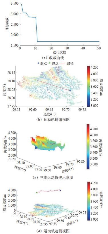
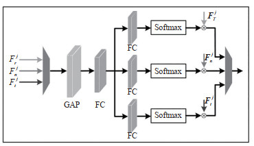
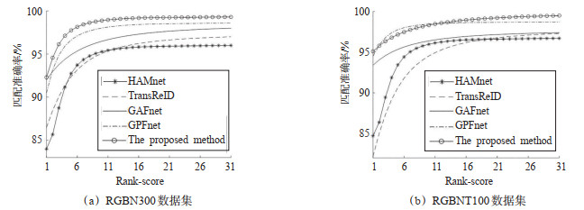
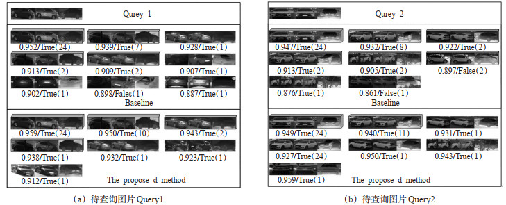
Current Issue

2025 Vol. 43, No. 4

Display Method:
2025, 43(4): .
Abstract(7) HTML (4) PDF(0)
Abstract:
A Review on Vulnerable Road Users' Attitudes Toward Autonomous Vehicles
HAN Xiao, TANG Yuan, SHENG Xiaolu, FANG Kexin, XING Yingying
2025, 43(4): 1-13. doi: 10.3963/j.jssn.1674-4861.2025.04.001
Abstract(5) HTML (4) PDF(1)
Abstract:
The widespread adoption of autonomous driving technology depends not only on technological progress but also on public attitudes. In real-world operations, autonomous vehicles inevitably interact with vulnerable road users, including pedestrians, cyclists, elderly people, children, and persons with disabilities. Investigating these groups' attitudes toward autonomous driving and the factors that shape them is crucial for fostering social acceptance and ensuring the safe deployment of this technology. This review outlines the potential advantages of autonomous vehicles. It focuses on the attitudes of vulnerable road users and their influencing factors, aiming to provide guidance for researchers, technology developers, and policymakers in technological improvement and policy design. The findings indicate that most vulnerable road users generally hold positive attitudes toward autonomous vehicles. Younger male pedestrians and cyclists show stronger support. Persons with disabilities view them as opportunities for enhanced mobility, whereas older adults, due to lower adaptability, tend to prefer conventional vehicles. Familiarity with the technology further improves acceptance. Nevertheless, safety and reliability remain critical barriers to trust. Pedestrians and cyclists worry about road interaction risks. Persons with disabilities are concerned about design flaws and loss of independence. Older adults feel uneasy about interacting with new technologies, and parents express concerns over child safety features. The review also summarizes policy measures and practices in several countries aimed at protecting vulnerable road users, offering lessons for safety assurance in the era of autonomous driving. Finally, it highlights future research directions, including expanding study populations and geographical scope, adopting experiential research methods, conducting longitudinal studies, applying latent class analysis to identify subgroup differences, and differentiating between technical levels and operational models. These efforts will advance the understanding of how vulnerable road users' attitudes evolve and provide valuable insights for technology development and policy refinement.
Collision Avoidance and Early Warning Method for Inland Bridge Areas Based on Enhanced Safety Potential Fields
HUANG Liwen, WEN Teng, LI Haoyu, ZHAO Xingya, ZHANG Kun
2025, 43(4): 14-23. doi: 10.3963/j.jssn.1674-4861.2025.04.002
Abstract(6) HTML (3) PDF(0)
Abstract:
To precisely quantify the dynamic evolution of vessel collision risks in inland bridge zones and enable tiered early warning, this study proposes an assessment method integrating vessel dynamic motion prediction with multi-dimensional potential field coupling. By adapting traditional safety potential field models to account for vessel navigation characteristics and bridge zone environmental constraints, the approach is applied to vessel-bridge collision risk evaluation. Based on risk causation theory, bridge zone risks are decomposed into four elements: static obstacles, channel constraints, human decision-making, and vessel kinetic energy. Static potential energy fields, boundary potential fields, behavioral potential fields, and time-varying kinetic energy fields are constructed respectively. Weighted allocation achieves coupling among these four potential fields. To address nonlinear vessel motion and prediction uncertainties caused by wind-induced flow disturbances, the Kalman filter algorithm processes automatic identification system (AIS) data in real time. This corrects process noise and observation noise to predict vessel dynamic deviations, which serve as correction parameters for the time-varying kinetic energy field, enhancing the potential field model's accuracy in representing dynamic risks. The time-varying kinetic energy field is superimposed with the improved potential field model to generate a comprehensive predicted field strength. This is combined with measured AIS data to produce an observed field strength, establishing a "prediction-observation" dual-field coupling early warning mechanism. Dynamic thresholds are set based on relevant regulations and historical cases to trigger graded warnings. Experimental validation conducted at the Chizhou Yangtze River Highway Bridge revealed: predicted field strengths at time points T2, T3, and T4 were 0.75, 0.64, and 0.45, respectively, while actual field strengths were 0.65, 0.59, and 0.40. The maximum relative error of 13.3% occurred at T2 during the bridge pier passage. The experiment confirmed the model's real-time capability and accuracy in collision risk warning for vessels passing under inland river bridges. The dual-field coupling mechanism enables controllable-error warnings in high-risk pier zones, providing dynamic risk quantification for vessel navigation decision-making.
A Methodology for Macroscopic Airspace Traffic Risk Modeling and Assessment under Manned-unmanned Integrated Operations
SHANG Ranran, HU Minghua, YANG Lei, REN Yumeng, LI Yangjie
2025, 43(4): 24-36. doi: 10.3963/j.jssn.1674-4861.2025.04.003
Abstract(5) HTML (3) PDF(0)
Abstract:
Integrating manned and unmanned aircraft into shared airspace presents significant challenges to airspace safety assessment. Existing risk assessment studies primarily focus on tactical collision risk evaluation based on trajectory prediction, while strategic-level systematic risk assessment for airspace planning and design remains underdeveloped. To comprehensively evaluate airspace safety levels and support the safe large-scale integration of unmanned aircraft into controlled airspace, this study investigates a macroscopic traffic risk modeling and assessment method for integrated operations. Static risk indicators are constructed based on the structural characteristics of routes and intersections, incorporating geometric morphology and conflict-prone profiles. Dynamic risk indicators are proposed in both horizontal and vertical dimensions, based on traffic flow characteristics. By coupling static complexity with dynamic conflict risks, an integrated airspace traffic risk assessment model is established, reflecting both the static features of the airspace structure and the dynamic characteristics of aircraft operations. Using four sector areas in Shanghai as an example, a risk assessment is conducted under manned aircraft operational scenarios to validate the model's feasibility and effectiveness, and to determine the target safety level for the airspace. Simulation experiments are designed to explore the influence mechanism of the three parameters, speed difference, separation, and mix ratio, on risk under integrated operation. Based on the criterion of not exceeding the target safety level, an equivalent risk assessment approach is adopted to determine the feasibility of manned-unmanned integrated operations. The allowable number of unmanned aircraft that can be introduced into each manned route is evaluated. The results show that: ①Speed difference and separation are the core driving factors of risk. The influence of mix ratio on airspace traffic risk depends on the separation setting. When the minimum safety separation between manned and unmanned aircraft is significantly larger than that between manned aircraft or between unmanned aircraft, the risk peaks when unmanned aircraft account for about50% of the traffic mix. ②Complex interactions are observed among speed difference, separation, and mix ratio, with no additional higher-order coupling effects detected. ③High -risk initial periods are not conducive to the introduction of unmanned aircraft.
A Collision Model for Fixed-wing Aircraft over Highways Considering Visual Blind Zones
CHANG Yinxia, ZHANG Shiqing, JIN Huibin, LI Weiling, ZHANG Zhaoyue, YANG Changwei
2025, 43(4): 37-45. doi: 10.3963/j.jssn.1674-4861.2025.04.004
Abstract(6) HTML (5) PDF(0)
Abstract:
To address the problem of the negative influence of visual blind spots on pilots'judgment of safe distances during emergency road landings of small fixed-wing aircraft, thereby increasing the probability of collisions with ground vehicles, this study constructs a low-altitude aircraft-ground vehicle collision model considering visual blind spots and uses SA60L as a research object. It quantitatively analyzes the effects of multiple factors on collision risks. Based on the landing characteristics of the SA60L aircraft, a three-dimensional visual blind spots model for the visual landing process is established. A three-dimensional coordinate system is constructed by using the pilot's position as the base point and combined with a 20° downward visual angle constraint to determine the projection range of the visual blind spots on the ground. Collision scenarios are classified into two categories by integrating parameters such as vehicle drivers'reaction time, thus a collision probability model is established. For collisions with rear vehicles, collision probability formulas are derived from three states: no braking, speed not reduced to 0 after braking, and speed reduced to 0 after braking. For collisions with front vehicles, the collision probability calculation logic is established under the conflict conditions that the aircraft landing roll distance covers the front vehicles. The three-dimensional visual blind spots are used as a pre-constraint for probability calculations, and the computation using the Monte Carlo method is activated to conduct 10, 000 simulations only when ground vehicles enter dangerous areas. These simulations analyze how ground vehicle speed, traffic flow, aircraft near-ground speed, and landing altitude affect collision risk and construct a multiple linear regression model. The results indicate that ground traffic flow (t =15.78) and ground vehicle speed (t =9.25) have the most significant impact on collision probability, with both factors showing approximately linear positive correlation with collision probability and increasing ground vehicle speed leads to an increase in collision probability amplitude. Landing altitude has a nonlinear"first increase then decrease"effect on collision probability. A high-risk zone is formed when ground vehicle speed exceeds 80 km/h and landing altitude is below 200 m, where collision probability increases from 0.12 in the safety threshold zone (speed < 40 km/h and altitude > 200 m) to 0.27, representing a 2.3-fold increase. The determination coefficient of the multiple linear regression model is R2 =0.965, indicating good fitting and significance.
A Reliability Design of Circular Curve Radius of Highway Under Mixed Traffic Flow
ZHANG Hang, HU Yingpeng, PENG Xiang, SUN Yu, LYU Nengchao
2025, 43(4): 46-56. doi: 10.3963/j.jssn.1674-4861.2025.04.005
Abstract(6) HTML (6) PDF(0)
Abstract:
The insufficiency of stopping sight distance (SSD) on highway curves due to roadside obstructions is a critical issue for mixed traffic flow composed of autonomous vehicles (AVs) and human-drive vehicles (HDVs). Traditional deterministic models for addressing this have limitations. Therefore, the minimum circular curve radius ensuring sight distance safety for this mixed traffic flow is investigated. The vehicle braking process is modeled in three stages, incorporating anti-lock braking system (ABS) and the lateral clearance method. Calculation models for SSD and available sight distance (ASD) are developed for various lanes and curve directions. This quantifies sight distance supply and demand under the most critical conditions. A reliability-based model is developed to assess sight distance for given curve radii. This model accounts for random variations in operating speed and braking reaction time of both drivers and autonomous systems, across different AVs penetration rates. The probability of SSD for the general minimum radius specified in the Design Specification for Highway Alignment (hereinafter referred to as standard values) is calculated. Using 95% as the target reliability probability, the recommended values for the minimum radius of circular curves and corresponding safe speed limits under various radii scenarios are proposed. The rationality of these recommended values is verified through SUMO simulations. Results indicate that when the AVs penetration rate is 0%, the reliability probability for the innermost lane of left-turning curves is lower than 95% when using the standard values. Higher AVs penetration increases the reliability probability, allowing for smaller minimum curve radii and higher safe speeds. SUMO simulations verify that the recommended values reduce traffic conflicts by 71.1% and improve traffic efficiency by 27.3% on average, compared to the standard values. Further increasing the curve radius provides no significant benefit.
Impacts of Combinations of Visual Information on Sidewalls of Urban Long Tunnel on Drivers' Vehicle Control Abilities
YI Xuanxuan, PAN Ting, DU Zhigang, HE Shiming
2025, 43(4): 57-66. doi: 10.3963/j.jssn.1674-4861.2025.04.006
Abstract(4) HTML (3) PDF(0)
Abstract:
To investigate the effects of different combinations of visual information on sidewalls on drivers'vehicle control abilities across various lanes in urban long tunnels, a driving simulation experiment was conducted. Statistical techniques and factor analysis were used to assess the influence of visual information types and lane positions. Results indicated that both combinations of visual information on sidewalls and lane positions significantly affected vehicle control performance, although no interaction effects were observed. Under the same lane condition, Scenario 1 (with horizontal stripes only) resulted in the highest driving speed, exceeding other three combination scenarios by 5.2~9.8 km/h. It also showed the highest longitudinal acceleration, surpassing others by 0.08~0.14 m/s2. In terms of lateral behavior, Scenario 1 exhibited greater lateral deviation than that in Scenarios 3 and 4 by 0.17 m and 0.16 m, respectively, and the maximum increase in lateral acceleration reached 0.051 m/s2. Under the same visual guidance condition, lane position also had a significant effect: driving speeds in the left and right lanes were 3.2 km/h and 2.1 km/h higher than that in the middle lane, respectively; the lateral acceleration in the left lane exceeded that of the middle and right lanes by 0.454 m/s2 and 0.495 m/s2, respectively. Overall, driving behavior indicators in the left lane were higher than those in the middle and right lanes, suggesting that the left and right lanes pose relatively higher driving risks. Further, factor analysis revealed that closed-type visual combinations were the most effective in enhancing vehicle control in the left and right lanes, while the wavy rhythmic pattern was better suited to improve control abilities in the middle lane. Therefore, it is recommended that closed-type visual combinations are prioritized in practical engineering applications, while wavy rhythmic patterns may be used in fatigue alert zones to enhance driving safety.
Multi-classification Prediction and Interaction Effects of Determinants for Accident Severity on Two-lane Highways in Plateau Mountainous Region
KONG Lingzhi, XIONG Changan, TANG Jintao, YANG Wenchen
2025, 43(4): 67-74. doi: 10.3963/j.jssn.1674-4861.2025.04.007
Abstract(7) HTML (4) PDF(1)
Abstract:
Current studies suffer from the insufficient prediction accuracy for multi-classification prediction and unclear interaction mechanisms for accidents severity on two-lane highways in plateau mountainous region. To address these issues, this study proposes an XGBoost-based three-classification prediction framework, optimized by a genetic algorithm (GA). The framework is tested based on accident data from 2012 to 2017 on mountainous two-lane highways in Yunnan. It integrates 14 features, such as road geometry, traffic environment, and type of involved vehicle. The model performance is compared with random forest (RF), support vector machine (SVM), and the baseline XGBoost model. Additionally, partial dependence plots (PDP) are used to explore the influence mechanisms of different risk determinants on accident severity. The results show that: ①The proposed GA-XGBoost model has the best overall prediction performance, with accuracy, precision, and recall rates reaching 81.57%, 73.12%, and 82.68%, respectively. After optimization with the GA algorithm, the predictive accuracy for injury and fatal accidents improves by 14.58% and 50.00%, respectively, compared to those of the pre-optimization model. The number of correctly classified fatal accidents is three times than that of the RF and SVM models. All these show significant improvement of the ability to predict severe accidents. ②Factors reflecting vehicle characteristics and traffic environment have a more significant impact on accident occurrence. Among them, the type of causing-trouble vehicle, type of involved vehicle, accident type, and daily traffic volume are the top four risk factors. ③Regardless of the type of accident, when pedestrians or motorcycles are involved, the severity of the accident is significantly increased. Among them, pedestrian involvement increases the severity of the accident by 1.25 to 5 times higher than that of any other involvement type. Additionally, as traffic volume increases, the impact of side collisions on accident severity gradually increases.
A High-precision Tracker for Small Objects in Intelligent Vessel Navigation Scenarios
SHAO Zeyuan, YIN Yong, LYU Hongguang, JING Qianfeng, WANG Haichao
2025, 43(4): 75-85. doi: 10.3963/j.jssn.1674-4861.2025.04.008
Abstract(2) HTML (2) PDF(0)
Abstract:
Tracking small sea-surface objects is crucial for environmental perception in intelligent vessels. However, due to the limited feature information of small objects and the motion-induced instability of shipborne cameras, existing methods still face challenges in tracking accuracy and stability. To address these issues and enhance the performance of small sea-surface objects tracking, a novel tracker named SeaMicroTracker is developed. The tracker integrates deep learning-based object detection with an optimized object association algorithm to enhance robustness. Specifically, for object detection, an enhanced Convolutional Neural Network (eYOLOv5) model is employed to accurately extract the positional information of small sea-surface objects. For object association, an observation-centric Kalman filter (OKF) is designed to enhance state estimation reliability under shipborne camera motion. Additionally, a Manhattan distance-based intersection over union (MDIoU) metric is proposed to improve association accuracy in dynamic maritime environments. Furthermore, a progressive refinement cascade matching (PRCM) strategy is developed to improve the tracker's adaptability to complex maritime conditions and target occlusions, thereby further enhancing target association performance. Experimental results on the Jari maritime tracking dataset show that SeaMicroTracker achieves a multiple object tracking accuracy (MOTA) of 80.6 and an identification F1 score (IDF1) of 64.0, demonstrating significant advantages in tracking accuracy and stability. Compared with the baseline method ByteTrack, the proposed tracker improves MOTA and IDF1 by 27.9% and 34.7%, respectively, while effectively reducing ID-switching events. Moreover, the tracker achieves an average tracking speed of 30.1 FPS, satisfying real-time requirements for engineering applications.
Autonomous Navigation Method for Ships in Tidal River Sections Under Special Rule Constraints
HE Yixiong, CHAI Lutong, WANG Bing, ZHAO Xingya, DAI Yonggang, HUANG Liwen
2025, 43(4): 86-97. doi: 10.3963/j.jssn.1674-4861.2025.04.009
Abstract(3) HTML (3) PDF(0)
Abstract:
To address the issue of autonomous ship navigation under the constraints of special navigation rules in tidal river sections, a case study is conducted using the Nantong section waters, focusing on situation awareness, rule integration, and maneuvering decisions. Based on environmental characteristics and decision-making requirements, an innovative digital traffic environment model for tidal river sections is developed by incorporating channel factors and tidal conditions into the traditional digital traffic environment model. Driven by real data, this model is transformed into an information database recognizable by decision-making programs. The system reads the database to perceive the real-time status and development trends of environmental elements near the own ship, providing input for critical processes such as decision-making and control. The"Inland Waterway Collision Avoidance Rules" and good seamanship requirements are quantitatively analyzed. By integrating the channel direction and angle-on-the-bow comparison in tidal river sections, an improved model for identifying encounter situations based on angle-on-the-bow comparison is developed. An innovative model for identifying encounter situations and collision avoidance responsibilities in tidal river sections is established, clarifying the responsibilities and timing of actions during flood and non-flood tides, and converting these into computable constraint equations. Under the constraints of environment, collision avoidance responsibilities, and maneuverability, a novel autonomous navigation method is proposed to adaptively account for tidal influences and derive collision avoidance solutions. Two sets of simulation experiments and a comparative experiment are conducted in a real-data-driven general aviation environment. The simulation results demonstrate that, under different tidal conditions, the proposed method can accurately identify encounter situations, determine collision avoidance responsibilities, and calculate and execute course and speed change plans to avoid all targets. In the comparative experiment, under the inland wide waterway navigation decision-making method, the own ship alters course 5° to starboard at t = 1 s to avoid the target ship, resulting in incorrect collision avoidance responsibility judgment, with action timing and magnitude not complying with special rules and good seamanship requirements. In contrast, the proposed method, which accounts for tidal conditions and the own ship's navigation state, alters course 15° to starboard at t = 201 s, ensuring safe passage in compliance with requirements.
Trajectory Planning and Energy Consumption Evaluation Model of UAVs in Plateau and Mountainous Areas
WU Jingqiong, TIAN Na, CHEN Ziwei, DIAN Ran, LI Yunqi
2025, 43(4): 98-109. doi: 10.3963/j.jssn.1674-4861.2025.04.010
Abstract(2) HTML (3) PDF(0)
Abstract:
To address the challenges of trajectory planning and energy evaluation for unmanned aerial vehicles (UAVs) in plateau mountainous terrains, a three-dimensional path planning and battery capacity evaluation method is proposed. High-resolution digital elevation data are applied to construct a 3D terrain model, incorporating constraints such as flight range, altitude, and path accuracy. A weighted optimization function with objectives of minimizing path length, altitude variation, and deflection angle is designed to build a UAV trajectory planning model that reflects terrain undulation. Deviations between spatial straight-line paths and actual flight trajectories are corrected, and the effects of lateral distance flight and vertical altitude ascent on unit energy consumption are quantified. Based on this, a UAV battery capacity evaluation model is constructed to support energy analysis. An application is carried out in Jidi Village, Jiantang Town, Shangri-La City, Diqing Tibetan Autonomous Prefecture, Yunnan Province, where flight paths between a matsutake trading market and fifteen collection sites are evaluated. Results indicate that the corrected flight paths are 264—724 m longer than straight line paths, with an average correction of 438 m and an average correction rate of 7.64%. Energy consumption for single-point one-way tasks ranges from 28% and 58%, revealing task expansion potential. Among all flight routes, 38 potentially high-energy-risk routes and 4 significant high-risk routes are identified. Strategies including low-energy alternative routes, efficient UAV selection, and mid-route supply stations are found effective to reduce energy risks and enhance the feasibility of UAV transportation in plateau mountainous environments.
A Vehicle Re-identification Method Based on Feature Interaction and Multi-modal Adaptive Fusion
ZHANG Xunxun, ZHU Xu, LI Xiaowei
2025, 43(4): 110-118. doi: 10.3963/j.jssn.1674-4861.2025.04.011
Abstract(2) HTML (1) PDF(1)
Abstract:
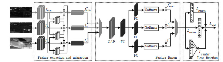
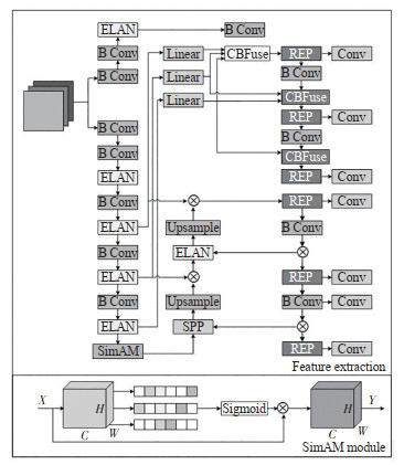
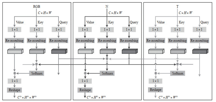
The limited resolution of visible-light sensors under weak illumination conditions and the insufficient representational capacity of a single modality lead to low vehicle re-identification accuracy. To address this problem, a vehicle re-identification method based on dynamic feature interaction and adaptive multi-modal fusion is proposed. In terms of network architecture, the SimAM module is embedded into the convolutional layers of the YOLOv9 backbone network without introducing additional parameters, enabling the modeling of spatial and channel relationships within features and extracting initial representations from visible, near-infrared, and far-infrared modalities. A multi-modal feature interaction module is then constructed to perform refined feature extraction and cross-modal information exchange, thereby obtaining enhanced features for all three modalities. Furthermore, a multi-modal adaptive feature fusion network is designed, in which the weighting coefficients for each modality are adaptively generated based on global vectors and mask vectors, achieving effective feature fusion. To handle large intra-class variance, small inter-class differences, and significant appearance variations of the same vehicle across different scenarios, ajoint loss function combining cross-entropy loss, contrastive loss, and center loss is introduced. The proposed method is trained and validated on the publicly available datasets RGBN300 and RGBNT100. The results show that compared with existing methods, the mean average precision (mAP) and the recognition accuracy of Rank-1, Rank-5, and Rank-10 are improved to varying degrees. Among them, mAP is improved by 20.6%, 29.0%, 5.0%, and 3.5% on the RGBN300 dataset, and 22.5%, 12.0%, 3.7%, and 3.0% on the RGBNT100 dataset. Rank-1, Rank-5, and Rank-10 of the RGBNT100 dataset achieves 95.1%, 96.7%, and 96.9%. The experimental results show that feature interaction and adaptive multi-modal fusion lead to more discriminative features and excellent vehicle re-identification performance.
A Dynamic Pushback Control Model for Departure Flights Considering Reapplication Intervals
YANG Jingge, AI Qiuchi, HUANG Shan, LIAN Guan
2025, 43(4): 119-128. doi: 10.3963/j.jssn.1674-4861.2025.04.012
Abstract(2) HTML (2) PDF(0)
Abstract:
Long taxiway queues during the departure process of flights at large hub airports will cause large fuel consumption and exhaust emissions. Aiming to tackle this problem, an improved N-control linear policy (NCLP) with multiple application intervals is proposed based on the traditional N-Control strategy. The model can gradually reduce the flight exit permission rate when the real-time queue length exceeds the set/predefined/configured optimal taxiway queue length threshold, achieving more flexible dynamic departure control. The taxiway queuing system and boarding gate virtual queuing system are built by setting the intervals for flight resubmission equal to the runway service time. A comprehensive cost objective function for taxiway fuel consumption and boarding gate occupancy penalty is constructed. A continuous time Markov chain based optimization algorithm is proposed to achieve a dual loop between taxiway capacity and dynamic pushback control strategy, thus determining the optimal taxiway queue threshold between fuel consumption and gate penalty cost. A simulation experiment is conducted on the actual operating data of Beijing Capital International Airport. The results show that when the length of the taxiway queue reaches the optimal threshold, the NCLP control strategy has significant advantages over the uncontrolled situation and the traditional N-Control strategy. This model can reduce the average taxi waiting time from 9.51 min to 6.94 min throughout the day, and reduce fuel consumption and total operating costs by 27.07% and 23.91% respectively compared with the N-Control strategy, which verifies the effectiveness of the proposed model in reducing airport taxi fuel consumption.
Driver Workload and Behavioral Characteristics at Urban Unsignalized Intersections Under the Influence of Human-machine Interaction Systems
JU Yunjie, CHEN Feng
2025, 43(4): 129-138. doi: 10.3963/j.jssn.1674-4861.2025.04.013
Abstract(2) HTML (1) PDF(0)
Abstract:
Human-machine interaction systems (HMIs) play a vital role in enhancing the driving experience. However, whether additional interaction information overloads driver workload and affects behavioral performance remains unclear. For this purpose, the study recruits 29 participants for a driving-simulator experiment. It measures the detection response task (DRT), NASA Task Load Index (NASA-TLX), and driving behavior parameters, and analyzes driver workload and behavioral characteristics across HMI systems and conflict types, while considering their interaction effects. Results show that: ①Under integrated visual-auditory information, drivers'DRT response time decreases 12.1% and hit rate increases 5.8%—48.5%. This suggests drivers establish high situational awareness and can allocate more cognitive resources to DRT requests. Additionally, in cross-conflict environments, drivers frequently monitor surrounding traffic to determine other road users'positions and trajectories. As a result, DRT response time increases 14.8%, and hit rate decreases 22.6%. ②Based on NASA-TLX, under integrated visual-auditory information, effort scores decrease 21.7%—22.8%. Drivers consider they can reach expected performance levels more easily than others. Perceived time pressure decreases 19.8%, indicating a more relaxed and composed driving pace. Frustration scores decrease 31.4%—32.9%, and negative emotions including insecurity, discouragement, irritability, tension, and annoyance decrease. ③With sufficient space and time margins for safety-critical events, drivers with integrated visual-auditory information show a 32.1% reduction in speed standard deviation. Acceleration noise decreases 26.9%, and lateral offset standard deviation decreases 7.1%. Driving becomes smoother and more comfortable, with better lane-keeping ability and improved lateral control stability.
Identifying the Determinants of Travelers Choosing Electric Vehicles in the Context of Intercity Travel
HOU Gen, TIAN Lun, PAN Xiaofeng, XUE Xiaowei
2025, 43(4): 139-148. doi: 10.3963/j.jssn.1674-4861.2025.04.014
Abstract(1) HTML (1) PDF(0)
Abstract:
Due to the current battery techniques and travelers' range anxiety, the electric vehicles are most commonly used in the context of intra-city travel. In order to improve the usage of electric vehicles, it is necessary to investigate travelers' choice toward electric vehicles in the context of intercity travel. To this end, this study conducted a survey based on a stated preference experiment, where the respondents are requested to choose electric vehicles or fuel vehicles based on the given travel context. 400 valid questionnaires are finally collected. Next, a mixed Logit model is established and travelers' heterogeneous preferences toward electric vehicles are analyzed, based on which travelers' value of time and the elasticity of electric vehicles' endurance mileage are computed and related policy implications aiming to increase the market share and usage of electric vehicles are put forward. The research results show the following conclusions: ①The considered attributes in the experiment significantly influence travelers' choosing electric vehicles for intercity travel. Specifically, the taste parameter of ratio of freeway follows a normal distribution with μ =-0.473 and σ =0.818 for electric vehicles and a normal distribution with μ =-0.576 and σ = 1.371 for fossil-fueled vehicles, respective; the taste parameter of congested travel time for electric vehicles and endurance mileage follow negative log-normal distribution with μ =0.397 and σ =0.422 and log-normal distribution with μ =-1.053 and σ =0.356, respectively. ②In terms of electric vehicles, travelers have largest value of time when congested traveling (133.16 CNY/h), followed by those when queueing for charging (71.83 CNY/h), charging (54.05 CNY/h) and free traveling (52.50 CNY/h) in sequence. In terms of fossil-fueled vehicles, travelers have largest value of time when queueing for fueling (453.43 CNY/h), followed by those when congested traveling (159.14 CNY/h), free traveling (60.57 Yuan/h) and fueling (54.05 CNY/h) in sequence. ③If electric vehicles' endurance mileages are increased by 1%, its corresponding market share of sample in this case study would be increased by 0.17%.
Prediction and Evaluation Methods for Large-Scale Flight Delay Propagation Based on Spatiotemporal Network
QU Jingyi, XING Jialong, WANG Jinfeng, YANG Jun
2025, 43(4): 149-159. doi: 10.3963/j.jssn.1674-4861.2025.04.015
Abstract(2) HTML (1) PDF(0)
Abstract:
The highly coupled nature of flight operations in spatial and temporal dimensions leads to the widespread propagation of large-scale delays across multiple airports. This issue is addressed through using dynamic network analysis to explore the patterns of air traffic delay propagation. To accurately capture the dynamics of delay spread, a spatiotemporal network is constructed where airports are nodes, departing flights are edges, and a temporal resolu-tion is 5 min. In constructing the flight delay spatiotemporal graph, edge weights are improved. Initially estimated using statistical averages of delay times or simple empirical rules, the weights are predicted via deep learning. For the flight delay prediction task, a multi-task NR-DenseNet model is employed to simultaneously predict flight delay duration (regression) and delay occurrence (classification), enhancing the accuracy and timeliness of the weights. By comparing performances across different network depths, experiments demonstrated that a 16-layer NR-DenseNet achieved optimal performance in both tasks. The regression prediction yielding a mean squared error (MSE) of 58.30 and a mean absolute error (MAE) of 3.28, while classification accuracy reached 94.8%. Regarding metric evaluation, single metrics are found to be insufficient for fully assessing the complexity of air traffic delay propagation. Therefore, three evaluation metrics, intensity, propagation rate, and velocity, are established to quantita-tively analyze the multidimensional characteristics of delay spread. Using domestic data from the East China Air Traffic Management Bureau as the study, the results indicated that the proposed method effectively reveals the spa-tiotemporal details of large-scale delay propagation within the scheduled flight timetable.
Risk Assessment of Fresh Cold Chain Logistics Based on Fuzzy DBN
MA Ying, JUAN Wenlu, WANG Shiying
2025, 43(4): 160-167. doi: 10.3963/j.jssn.1674-4861.2025.04.016
Abstract(2) HTML (2) PDF(0)
Abstract:
To address problems such as numerous risk factors and time-varying risk states in fresh cold chain logis-tics, a risk assessment method for fresh cold chain logistics is studied based on the fuzzy dynamic Bayesian network (DBN). To improve the efficiency of dynamic risk assessment for fresh cold chain logistics and accurately identify key risk triggers. From the perspective of full-process and multi-dimensional integration, the entire operation pro-cess of fresh cold chain logistics is deconstructed using the decomposition analysis method. Core indicators are screened in depth by combining the EWM and TOPSIS. Through these steps, a full-process and multi-dimensional risk assessment indicator system for fresh cold chain logistics is constructed. Meanwhile, fuzzy theory is integrated, and fresh product characteristic parameters are incorporated to determine the conditional probability distribution of the DBN. Thus, a DBN risk assessment model for fresh cold chain logistics is established. An empirical analysis is conducted with a fresh cold chain logistics enterprise in Wuhan as the research object. The DBN risk assessment model is built using GeNIe software, and the probabilities of risk factors in fresh cold chain logistics are evaluated. Results show that the occurrence probability of fresh cold chain logistics risks increases from 0.24 to 0.31 over time. Among all links, the transportation link exhibits the highest risk occurrence probability and constitutes a key risk variable in the fresh cold chain logistics system. Storage risks are prone to transfer to the transportation link due to improper stacking methods and unsuitable storage temperatures as time passes. This transfer leads to an approxi-mately 10% increase in transportation risks, which exerts the greatest impact on fresh cold chain logistics risks. Compared with the static BN, the accuracy of the fuzzy DBN risk assessment is improved by 19.73%.
A Design & Optimization Method for Intercity Demand-responsive Transit Considering Passengers' Choice Behavior
YANG Hongtai, YANG Zijian, LIU Xiang, ZHENG Rong, LIU Zheng, GE Qian, JI Ang
2025, 43(4): 168-180. doi: 10.3963/j.jssn.1674-4861.2025.04.017
Abstract(2) HTML (1) PDF(0)
Abstract:
Demand-responsive transit is an emerging reservation-based travel service. However, existing studies have mainly focused on intracity context, while studies on service design and optimization in intercity context re-main limited. Meanwhile, current models typically pursue a single operator-oriented objective, such as operational cost minimization or profit maximization, but rarely incorporate operation profits and consumer surplus, thereby lim-iting their ability to enhance overall social welfare. Additionally, most studies assume fixed demand density and fail to adequately involve passengers'choice preferences. To address these shortcomings, this study incorporates passen-gers'choice behavior and develops a design & optimization model for intercity demand-responsive transit (IDRT) service. The objective of this model is maximizing social welfare, which is defined as the sum of operation profits and consumer surplus. The decision variables include departure interval, service-area ratio between the major city and satellite cities, and ticket fare. The model is formulated using the continuous approximation method and solved with the Lagrange multiplier method. Furthermore, the optimal solutions of models with social welfare maximiza-tion and operation profit maximization are compared. Results show that although operation profit is negative in the model of social welfare maximization, an appropriate subsidy can raise social welfare from 54.976 CNY/h to 110.906 CNY/h, demonstrating the effectiveness of the proposed method. The results of the sensitivity analysis on se-lected model parameters indicate that the service area of satellite cities has only a minor impact on social welfare and is not a key constraint in IDRT layout, whereas length of intercity highway has a significant influence on passen-gers'choice behavior, highlighting the importance of empirical surveys for rational deployment of IDRT layout. Over-all, the proposed method not only provides decision-makers with a practical tool to determine departure intervals, ser-vice-area allocation, and ticket fares given demand density conditions, but also assists them in selecting appropriate vehicle types based on sensitivity analysis, thereby improving both operational efficiency and social welfare.