2022 Vol. 40, No. 5

Display Method:
2022, 40(5): .
Abstract(949) HTML (595) PDF(65)
Abstract:
A Review of Parameter Identification Methods for Ship Dynamic Models
ZHU Man, WEN Yuanqiao, SUN Wuqiang, ZHANG Jiahui, HAHN Axel
2022, 40(5): 1-11. doi: 10.3963/j.jssn.1674-4861.2022.05.001
Abstract(1217) HTML (346) PDF(168)
Abstract:
Developing a dynamic model with a high accuracy and reliability is essential for analyzing ship maneuverability and ensuring shipping safety. Compared with the existing three popular methods, including empirical, experimental and computational fluid dynamics (CFD), numerical parameter identification methods are practical, effective, and powerful solutions for dynamic modeling. However, it faces major challenges due to the influences from the following factors, such as strong nonlinear motion characteristics of ships, varying environmental interfer-ences, and the multiple internal and external uncertainties. This paper reviews the state-of-the-art of parameter identification of ship dynamic models from the following four critical perspectives, including the optimal input design related to the informative characteristics acquisition, the mathematical model of ship motion, parameter estimation algorithms, and the verification and validation of the identified models. Several critical problems are discussed including noise interference, parameter drift, parameter variation, and selection of evaluation indexes. Based on a comprehensive survey, two challenging issues are pointed out. Currently, there is no method available that can provide high-quality data covering motion characteristics over a wide area, and due to the complexity of the models, the parameter drift fluctuates and cannot be completely avoided. Potential research questions closely related to the parameter identification of ship dynamic models are discussed. For instance, ship dynamic data acquired and processed using robust estimation techniques or information fusion techniques is worthy to be addressed to provide high-quality data; robust online parameter identification based on the multi-innovation intelligent approach can be a valuable solution to real-time identification of ship dynamic models; and complex conditions, such as ships sailing in restricted waters, should to be examined.
A Review on Anti-skid Performance Based on Fractal Characteristics of the Texture of Asphalt Pavement
GAO Qiannan, GUO Runhua, GENG Jingjie
2022, 40(5): 12-22. doi: 10.3963/j.jssn.1674-4861.2022.05.002
Abstract(587) HTML (225) PDF(43)
Abstract:
Texture morphology of asphalt pavement is an important indicator of the anti-skid performance of asphalt pavement. Meanwhile, pavement texture has its fractal characteristics. Therefore, it is important to study the correlation between pavement texture and anti-skid performance by quantifying its texture with fractal properties. Single and multi-fractal properties of pavement texture and aggregate texture are studied and summarized at both the macroscopic and microscopic levels. The applications of fractal theory in the design of anti-skid gradations and selection of anti-skid aggregate for pavements are analyzed. A variety of design of anti-skid gradation models based on the fractal theory are summarized, and a new method of anti-skid aggregate selection for pavements based on the fractal theory is proposed. Finally, the utility of the fractal theory in combination with parametric statistical methods, mechanical analysis, and finite element simulation in the field of prediction of pavement anti-skid performance is compared and analyzed. Study results show that fractal feature analysis provides a new way for the description of pavement texture. However, the fractal analysis methods with a high precision are still the bottlenecks in this field. There are still limitations within the fractal models, in terms of their accuracy, standardization and systematization of their process. The application of fractal theory in combination with gradation design and aggregate selection is still in its preliminary stage. Therefore, it is recommended that design methods in engineering should be validated based on their usefulness in the practice. The performance of various types of prediction models for forecasting anti-skid performance based on texture fractal properties are compared. Study results indicate that the prediction mod-els based on finite element simulation can more accurately restore the tire-road contact state under complex conditions in practice, indicating that such prediction models have a good potential. Future research areas on anti-skid performance of asphalt pavement based on the fractal properties of texture are discussed and proposed, including the correlation between multi-scale texture fractal characteristics and anti-skid performance, criteria for specifying fractal parameters in the practice, and the development of intelligent anti-skid prediction system based on the fractal theory.
A Review of Progresses and Prospects of Human-machine Shared Control Technology for L2 Intelligent Driving Based on Haptic Guidance
DENG Xiujin, WANG Yanyang, HUANG Qiushi, WANG Ke, LIAO Kaikai
2022, 40(5): 23-33. doi: 10.3963/j.jssn.1674-4861.2022.05.003
Abstract(810) HTML (310) PDF(44)
Abstract:
It is nearly impossible for intelligent automobiles to achieve a fast upgradation from L1 to L5 in a short time due to the limitations of technologies, regulations, and other factors. Thus, human-machine shared driving will be the case for a long run. The human-machine shared control (HMSC) technology based on haptic guidance provides an effective way for intelligent automobiles operating at the L2 level. Through reviewing the literature regarding the current progress of HMSC technology, this study focuses on studying conflicts created over the human-machine collaboration in the process of route planning, intention commitment, and control assignment related to the maneuvers like lane keeping, lane changing, collision avoidance and backing-up, which may result in reduced vehicle stability, poor driving safety, and deteriorated operating comfort and freedom. Meanwhile, the driving styles and cognition differences of drivers are studied to identify the design methods of human-machine shared controller and the mechanism of human-machine conflict. Therefore, it is proposed that the intelligent driving system should be iteratively optimized base on massive simulated or measured driving data in the future and the accuracy of the intelligent driving system in recognizing driving environment and driver's status should be improved. In this way, the control weights of human and machine can be assigned and the problems of control conflict, vehicle stability, driving safety, deteriorated operating comfort and degree of freedom can be solved. Based on the existing issues identified within the research to date, it is pointed out that shared controllers based on the adaptive haptic-guidance, assignment of control weight, neuromuscular response, and advanced assistance systems are major research directions of the HMSC.
A Method of Risk Identification and Decision-making Support for Ship Maneuvers at Chengshanjiao Waters Under Traffic Separation Scheme
HE Yixiong, YU Deqing, LIU Xiao, WANG Feng, MOU Junmin
2022, 40(5): 34-43. doi: 10.3963/j.jssn.1674-4861.2022.05.004
Abstract(611) HTML (238) PDF(41)
Abstract:
Simulation of environment, risk identification, collision avoidance and decision-making support for ship maneuvers are studied in order to counteract the high risk associated with shipping at Chengshanjiao waters under traffic separation scheme(TSS). The shipping environment of the Chengshanjiao waters is analyzed and digitalized to develop a static nautical environment model, and the dynamic traffic is investigated to set up a digitalized shipping simulation system. A method for risk identification is proposed based on the positions of ships and a collision risk model considering both space and time dimension. Good Seamanship and International Regulations for Preventing Collisions at Sea(COLREGS)are used to summarize the principles of ship maneuvers in different scenarios, and a ship maneuver meeting the principle of"minimum course altering"is produced based on the collision avoidance mechanism. A decision-making model adaptive to the random motions of target ships is developed using a rolling-window method and a feedback compensation method. Shipping traffic at the Chenshanjiao waters is simulated and multiple-ship scenarios are introduced. Study results show that: ①The proposed risk identification method using dead reckoning can identify the risk 1 168 s earlier than the regular methods at the Chengshanjiao waters when the own ship locating at(41 200 m, 38 000 m)heading to 000°with a speed of 12 n mile/h encounters with the target ship at(44 600 m, 62 300 m)heading to 210° with a speed of 12 n mile/h. ②Under a simulated multiple-ship scenario, the own ship can avoid collisions with target ships by altering to the starboard 17° at 245 s, resuming to sail at 617 s, altering to the starboard 11° at 2005 s, and resuming to sail at 2 405 s, which meets the principle of Good Seamanship. In conclusion, the proposed method can identify the collision risk earlier and support decision-making on ship maneuvers better than other methods at the Chenshanjiao waters, which provides a theoretical foundation for developing intelligent navigation systems on waters under TSS.
A Reliability Analysis of the Capacity of Urban Road Network Under a Mixed Human-driven and Connected Traffic Environment
HAO Wei, XIAO Lei, ZHANG Zhaolei, ZHENG Nan
2022, 40(5): 44-52. doi: 10.3963/j.jssn.1674-4861.2022.05.005
Abstract(583) HTML (236) PDF(71)
Abstract:
The emerging of mixed traffic involving both connected autonom ous vehicles(CAVs)and human-driven vehicles(HDVs)may change the capacity of urban road networks. A bi-level programming model is proposed to analyze the impacts of mixed traffic flow on the reliability of the capacity of urban road network in an intelligent network environment. Assuming that CAVs follow the path selected based on the system optimization principle and the drivers of the HDVs select their paths according to their own experience, a lower model is developed for the assignment of traffic flow based on the differences in the path selection between the two types of vehicles. Furthermore, the modeling of the assignment of mixed traffic at the lower level is transformed into a nonlinear complementarity problem to reduce runtime. Considering the randomness of road capacity in a network, an upper model is set up for modeling the reliability of capacity by using a uniform random distribution with multiple correlations. A Monte Carlo simulation is used to analyze the reliability of road network capacity under different market penetration rate(MPR)of CAVs. A sensitivity analysis is then carried out for studying the reliability of road capacity under such a scenario. Numerical results show that, when the level of the demand d > 0.5, the reliability of road network capacity decreases. When level of the demand d > 0.7 and the market penetration rate of CAVs λ=0, the reliability is less than 0.4. However, when d > 0.7 and λ=1, the reliability is found close to 1, indicating that CAVs can enhance the reliability of road network capacity. It is also found that when the level of the demand is between 0.7 and 1, the MPRof CAVs significantly affects the reliability of road network capacity. When the road network is overloaded, the MPR has a very minor impact on the reliability of road network capacity with the increase of traffic demand. In addition, when λ increases from 0 to 1, the number of roads showing"capacity paradox"in the road network decreases from 19 to 3. When λ=1, only one road in the entire network show the issue. Study results show that the increase of MPR can not only reduce the possibility of"road capacity paradox", but also improve the stability of the road network.
An Analysis of Driving Behavior Model and Safety Assessment Under Risky Scenarios Based on an XGBoost Algorithm
WEI Tianzheng, WEI Wen, LI Haimei, LIU Haoxue, ZHU Tong, LIU Fei
2022, 40(5): 53-60. doi: 10.3963/j.jssn.1674-4861.2022.05.006
Abstract(823) HTML (318) PDF(88)
Abstract:
Hazard perception is a critical factor of a driving behavior model. A simulator-based method and an extreme gradient boosting tree(XGBoost)algorithm are proposed, in order to study the impacts of hazard perception on driving behaviors and improve the accuracy of hazard perception. Three typical scenarios of traffic conflicts are simulated, and a large amount of driving behavior data are collected. The correlation between hazard perception and driving behavior models is discussed under the three scenarios. The correlation analysis reveals that when hazard perception(e.g., dangerous behaviors of pedestrians)is weak, and the vehicle speed(p=0.01), braking reaction position(p < 0.01), and reaction time(p < 0.01)are significantly negatively correlated with the drivers'hazard perception. Based on the correlation analysis, the XGBoost algorithm is used to identify important features determining the capability of hazard perception of drivers. Then, a discriminant model of hazard perception is proposed with following the indicators, such as braking reaction position, reaction time, vehicle speed, braking depth, and acceleration. Compared the proposed method with Light Gradient Boosting Machine(LightGBM), Support Vector Machine(SVM), and Logistic Regression(LR)algorithms, it is found that the accuracy of the XGBoost-based method is 84.8%, its F1-score is 83.4%, and the area under the receiver operating characteristic Curve(AUC)is 0.959, which is better than the LightGBM(accuracy is 78.8%, F1-score is 76.7%, and AUC is 0.924), SVM(accuracy is 57.6%, F1-score is 42.2%, and AUC is 0.859)and LR algorithm(accuracy is 69.7%, F1-score is 65.5%, and AUC is 0.836). In conclusion, the proposed method can provide a more reliable way for understanding the capability of hazard perception of drivers and its impacts on driving behavior models.
Prediction of the Duration of Freeway Traffic Incidents Based on an ATT-LSTM Model
JIA Xingli, LI Shuangqing, YANG Hongzhi, CHEN Xingpeng
2022, 40(5): 61-69. doi: 10.3963/j.jssn.1674-4861.2022.05.007
Abstract(717) HTML (286) PDF(68)
Abstract:
In order to study the impacts of traffic incidents on freeway operation, a method for predicting the duration of freeway traffic incidents is studied. Time-dependent characteristics of traffic incidents on freeways are extracted from time series data based on the recurrent neural network (RNN) theory. The feature and the temporal attention layer of a long short-term memory (LSTM) network are combined to study the correlation between historical and current moment data. Based on attention (ATT) mechanism and the LSTM, a model for predicting the duration of traffic incidentson freeways is developed. Validation of the model is carried out based on traffic monitoring dataset collected in 2018 along the Xi'an Ring Freeway. The prediction accuracy of the proposed model is compared with the following models: back propagation neural network (BP), random forest (RF), support vector machine (SVM), and long short-term memory (LSTM). The impacts of different factors, including the types of events, weather conditions, types of vehicles, and traffic volume, on the duration is also analyzed. Study results indicate that under the condition of the same dataset, the mean absolute error (MAE), the mean absolute percentage error (MAPE), and the root mean square error (RMSE) of the ATT-LSTM model is 24.43, 25.24%, and 21.17, respectively, which is better than that of other models. The "type of events" has the maximum weight of 0.375 among all of factors considered within the model, followed by the "number of lanes" "vehicle type" and "weather". By using the hourly traffic volume at the entrances and exits of interchanges as the correction parameter, the prediction accuracy is improved, and the MAE, MAPE, and RMSE of the model is decreased by 21.3%, 7.5%, and 16.9%, respectively. This study improves the prediction accuracy of the duration of traffic incidents on freeways and provides technical support for their safe and efficient operation.
An Analysis of Severity of Traffic Accidents on Urban Roadways Based on Binary Logistic Models
ZHANG Jie, ZHANG Mengmeng, LI Hongyan
2022, 40(5): 70-79. doi: 10.3963/j.jssn.1674-4861.2022.05.008
Abstract(695) HTML (202) PDF(67)
Abstract:
In order to accurately identify the factors affecting the severity of traffic accidents on urban roadways, 4 587 records from the traffic accident database of a city in China from Year 2018 to 2020 are used. A series of binary logistic models are developed for property damage accidents, personal-injury accidents, and fatal accidents based on the data regarding the following four aspects, including participants, vehicles, roads, and environment. The impacts of location of dividing strips and the types of roadside protection facilities on the severity of accidents are analyzed. Further, the Hosmer-Lemeshow tests and the consistency tests are used to check the soundness of the models. The results from the binary Logistic models show that: ① locations of dividing strips have a significant effect on the severity of the accidents. The probability of fatal accidents of placing central dividing strips only is 2.304 times higher than placing both central and motor/non-motor dividing strips. On high-grade roads with central dividing strips, adding motorized/non-motorized dividing strips can effectively reduce the probability of accidents. ② The probability of fatal accidents for the roadside protection facilities being street trees and green belts is 1.982 times and 1.648 times higher than the roadside protection facilities being metal guardrails, respectively. Street trees as the type of roadside protection facilities are likely to lead to more serious accidents than metal guardrails. ③The probability of fatal accidents at night "with no streetlight" is 1.808 times higher than that "with streetlights" at night. No streetlight at night is a significant risk factor leading to the fatal accidents. ④ Drivers with a high-level of education are more likely to have property-damage accidents and personal-injury accidents. Fatal accidents are more likely to occur among drivers with a medium-level of education, and their probability of resulting in the fatal accidents is 2.049 times higher than drivers with a high-level of education. In conclusion, this study presents an analysis of the factors and their impacts on traffic accidents at urban roadways. Furthermore, it can serve as a theoretical support for the refined analysis of accident severity on urban roadways, as well as a reference for traffic safety planning and management authorities.
A Method for Identifying the Participants of Autonomous Transportation System Based on a BERT-Bi-LSTM-CRF Model
TANG Jinjun, TUO Haonan, LIU You, FU Qiang
2022, 40(5): 80-90. doi: 10.3963/j.jssn.1674-4861.2022.05.009
Abstract(664) HTML (341) PDF(35)
Abstract:
Autonomous Transportation System (ATS) consists of participants whose information is generally described by texts. In order to develop a knowledge graph of the participants of the ATS, it is necessary to accurately identify the participants from the texts. Therefore, an entity recognition method based on a BERT-Bi-LSTM-CRF model is developed to extract the participants of ATS. Specifically, a Bi-LSTM (bidirectional long short-term memory) model is used to bi-directionally extract contextual sequence information from the semantic characteristics, which are captured by a word embedding model—BERT (bidirectional encoder representation from transformers). The optimal results of sequence prediction are obtained through the CRF(conditional random fields). After the original text source related to transportation engineering is collected, preprocessed and annotated, a new dataset is developed for identifying the participants of the ATS. Moreover, a comparative experiment of the entity recognition is carried out based on the same dataset. The results indicate that the BERT model significantly improves the performance of identifying the participants. Compared with other methods such as CNN-LSTM and Bi-LSTM, the proposed method achieves the best performance. The overall F1-score of participants is 86.81%, which shows that the proposed BERT model can enhance the generalized capability of the detection methods by extracting the semantic features of participants. The for identifying each type of including "user" "operator" "supplier" "planner" and "maintainer" reaches 90.35%, 92.31%, 90.48%, 93.33%, and 95.00%, respectively. Therefore, it can be concluded from the study results that the proposed method is effective and accurate.
A Method for Safe Moving Paths and Tracking & Control of the Trajectory of Towed Taxiing-in Aircrafts
SUN Yankun, YANG Hui, ZHANG Wei, QIN Jiahao
2022, 40(5): 91-101. doi: 10.3963/j.jssn.1674-4861.2022.05.010
Abstract(581) HTML (199) PDF(29)
Abstract:
Under the circumstance that an aircraft cannot use its own power to taxi into a port after an emergency landing, towing the aircraft to the port using an aircraft tractor is necessary. Considering the safety clearance between aircraft wheels and airport runway, a hinge point over centerline(HPOC)method for the scenarios where the type of aircraft matches the airport category, and a geometric center over centerline(GCOC)method for the scenarios where the type of aircrafts does not match the airport category, is proposed, respectively. Based on these two methods, a dynamics model of the system is developed. Under the constraints of safety clearance and the aircraft's front angle, trajectory planning of the tractor-aircraft system is carried out. Based on the GCOC method, a continuous nonlinear trajectory tracking model is developed. The trajectory tracking problem with different weights and initial deviations is studied using a linear quadratic regular(LQR)method. Study results show that on an unmatched airport runway, when the tractor-aircraft system is taxiing in using the HPOC method, the wheels of the aircraft would potentially collide with. In contrast, the GCOC method can be used to meet the requirement of the minimum distance between the wheels of aircrafts and the edge of airport runways and taxiways. In the process of trajectory tracking and control for the system, when the weights for the horizontal and vertical coordinates of the geometric center of the aircraft main landing gear(Q1 and Q2), and the angle representing the attitude of the aircraft(Q3)are set to 100, and that for the angle representing the attitude of the tractor(Q4)is set to 0, that is, Q=(100, 100, 100, 0), the deviations between the actual and the reference trajectory are found to be between 0.05 and 0.1 m. The method can control the errors of the variables for measuring the system state within about 10 s and thus ensure the system maintains a stable state. Correction of the initial deviation can be done within 12 s, and the time span for the correction is acceptable compared to the time required(10 s)for the correction under the scenarios where the aircraft is taxiing in alone.
Identification of Bunching State of Bus Lines Based on a LightGBM Model
LIU Qian, XIAO Mei, HUANG Hongtao, MING Xiuling, BIAN Haoyi
2022, 40(5): 102-111. doi: 10.3963/j.jssn.1674-4861.2022.05.011
Abstract(516) HTML (222) PDF(21)
Abstract:
Actual headways of adjacent buses of a same line can be significantly shortened, compared with the departing intervals, due to the influences of road situations and other factors, resulting in adjacent buses arriving at the same bus station in a relatively short period of time. This is called "bus bunching" in the transit industry. Identification of the bunching state of bus lines(i.e., bunching or non-bunching)is a key step to improve the operation of the urban public transit system. A LightGBM model with its parameters optimized by a Bayesian algorithm is proposed and applied to identify the bunching state. First, 20 factors related to the following five aspects including bus stops, operation, passengers, time, and weather, which potentially influence the bus bunching state, are selected. Spearman correlation test and variance inflation factor are used to diagnose their multi-collinearity. Then, a binary Logit model is developed to identify the significant impact factors, based on which the LightGBM model is developed to identify the bus bunching state. The super parameters of the LightGBM model(which are used to determine model attributes and training process)are optimized by a Bayesian optimization and a random search optimization, respectively. Finally, bus operation data from the City of Xi'an, China is used to verify the proposed model. The efficiency of the above two parameter optimization methods(i.e., Bayesian and random search)are compared, and the identification accuracy of the proposed LightGBM model is compared with XGBoost, Random Forest(RF), Decision Tree(DT)and AdaBoost models. Study results show that: first, the following factors, including number of passengers, number of signal lights, number of business districts within a short range, driving length on the main road within a short-range and traffic congestion index have a significant impact on the bus bunching state; second, the accuracy of the LightGBM model with its parameters optimized with the Bayesian method is 1.31%higher than that model with its parameters optimized by the random search method; third, the accuracy of the proposed Bayesian optimized LightGBM model for identifying the two bus bunching states(i.e., bunching or non-bunching)reaches 82.89%, which is found to be better than the above competing models.
A Detection Method for Abandoned Materials on Road Surface Based on an Improved YOLO and Background Differencing Algorithm
ZHOU Yong, ZHANG Bingzhen, ZHANG Xiaoyong, LIU Yuming
2022, 40(5): 112-119. doi: 10.3963/j.jssn.1674-4861.2022.05.012
Abstract(1127) HTML (294) PDF(128)
Abstract:
Due to the problems such as low detection accuracy, limited types of materials that can be detected, and slow speed of detection algorithms for abandoned materials, a detection algorithm combining target detection based on deep learning and traditional image processing is proposed. The structure of the YOLOv5s detection algorithm is modified, in order to have a capacity of real-time detection. The downsampling module in YOLO is optimized using convolution; the original feature extraction network is replaced with a Ghost network to reduce the computational burden, and the anchor frame is designed to match the dataset according to the characteristics of the detected objects to improve the detection accuracy. The optimized YOLO algorithm is used to detect vehicles and pedestrians as traffic participants in the road scenes and the region of interest is set based on the detection results. By detecting foreground targets in the region of interest with a background differencing algorithm, and calculating the intersection and merger ratio between the foreground target and the detection results from the YOLO algorithm, the detection of road abandoned object can be completed after excluding the detected traffic participants. In the experiments of target detection, the improved YOLO algorithm has a detection speed of 20.67 ms for each frame without any drop in the detection accuracy, which is 16.42% faster than that of the original YOLO detection algorithm. Experimental results indicate that the mean average precision (mAP) of the traditional mixed Gaussian model algorithm is 0.51, while the mAP of the detection algorithm using the improved YOLO and background differencing is 0.78. The detection accuracy of the algorithm improves by 52.9%. The improved algorithm can be applied to scenarios where there is no data or sample data is limited. The detection time required for each frame is only 24.4 ms when the proposed algorithm is installed on a Jetson Xavier NX computer, and therefore it can be used to carry out real-time detection of abandoned materials.
A Location Optimization Model for Rapid Exit Taxiway of Military Airports Based on Utilization Rate and Runway Occupancy Time
ZHANG Wanheng, CHONG Xiaolei, LIU Guisong, LEI Jichao, HUANG Xuelin
2022, 40(5): 120-128. doi: 10.3963/j.jssn.1674-4861.2022.05.013
Abstract(511) HTML (188) PDF(10)
Abstract:
Current location models for designing rapid exit taxiways (RETs) mostly use the minimum runway occupancy time as their objective functions. These models are only applicable to civil airports, but not suitable for military airports with multiple aircrafts and multiple operation modes. In order to address this limitation, a location optimization model is developed by considering the comprehensive utilization rate (CUR) of RETs and comprehensive runway occupancy time (CROT). This paper uses a military airport with four types of aircraft and two different types of annual sortie ratios as the case study to prove the effectiveness of the proposed model. According to the probability density function of the landing distance required by aircrafts, the CUR is estimated for different RETs. At the same time, the CROT is estimated by a greedy algorithm. In addition, when the CUR is greater than 90% and the CROT is the minimum, the number and location of the rapid exit taxiways are determined. Then, this paper further analyzes the effect of different annual sortie ratios on the location of the rapid exit taxiway. Study results show that the new location optimization model has a better performance under the two types of annual sortie ratios. Finally, compared with the two traditional location models that only consider the utilization rate or the minimum runway occupancy time as design parameter, the proposed optimization model reduces the runway occupancy time by 18.42 s and 34.82 s, and enhances the runway efficiency by 34.2% and 40.6% respectively.
A Grey Relation Projection-Random Forest Prediction Model of Energy Consumption for Electric Buses Considering Driving Style
LIU Qiang, YAN Xiu, LU Yu, XIE Xiaomin
2022, 40(5): 129-138. doi: 10.3963/j.jssn.1674-4861.2022.05.014
Abstract(502) HTML (183) PDF(20)
Abstract:
In order to study the relationship between driving behaviors and energy consumption of electric buses, a prediction model of energy consumption based on the random forest algorithm is developed for electric buses. In order to address the negative impacts from the randomness of the sample data and the parameters characterizing driving behaviors, the grey relational grades of the parameters for representing driving behaviors and the projection values of the sample data are calculated by a grey relational projection method. The parameters representing driving behaviors that have a high correlation with energy consumption are selected as the input variables, and the sample data with a high similarity are used as the training and testing dataset. The variables representing driving styles, which are significantly correlated with energy consumption, are introduced into the model to further improve the accuracy. Driving styles are classified and labelled by a K-means clustering method. In addition, a grey relation projection-random forest(GRP-RF)model for predicting energy consumption of electric buses is developed by taking the driving styles and the selected parameters for representing driving behavior as input variables, and the energy consumption per kilometer as the output variable. The model is tested based on the operation data of electric buses from a bus line in the City of Guangzhou, and the impacts of the parameters representing driving behaviors on the energy consumption is analyzed under the following three typical scenarios: acceleration, braking, and operation stage. The results show that the root mean square error(RMSE)and mean absolute percentage error(MAPE)of the prediction model are 0.001 8 kW·h/km and 3.42%, respectively. Compared with the GRP-RF model and the random forest model without considering the driving styles, the RMSE is decreased by 35.71% and 48.57% and the MAPE is decreased by 38.82% and 46.81%, respectively. Moreover, study results show that the average energy consumption at the acceleration, braking, and operation stage is 1.066, 0.903 7, 0.955 2 kW·h/km, respectively. To keep the energy consumption lower than the average value at each stage, the accelerator pedal opening should be within 55% of its full capacity at the acceleration stage; the brake pedal opening should be controlled within 25%of its full capacity at the braking stage, and the speed should be limited within 40 km/h at the operation stage.
An Analysis of Mode Choice Behavior of Inter-city Travel in Urban Agglomeration Areas Using a Random-parameter Logit Model
HAO Xiaoni, SHI Wenhan, LIU Jianrong, HAN Yao
2022, 40(5): 139-146. doi: 10.3963/j.jssn.1674-4861.2022.05.015
Abstract(614) HTML (182) PDF(37)
Abstract:
In order to study the impact factors of mode choices of travel modes in inter-city transport, the Guangzhou-Shenzhen inter-city transport corridor in the Great Bay Area of Guangdong-Hong Kong-Macao in China is taken as a case study. Given that traditional multinomial Logit models have the issue of independence of irrelevant alternatives (IIA) and they cannot be used to analyze heterogeneous preferences of travelers, a random-parameter Logit model is applied in this study. An online/offline survey is carried out and a total of 534 questionnaires are obtained. In the survey, information including socio-economic attributes of travelers, psychological latent variables (i. e., perceptions toward comfort, reliability, and convenience of travel modes), and attributes of modes for inter-city travel is collected, with which a random-parameter Logit model is developed and estimated. The pseudo R2 of the model is 0.178 at convergence, indicating a good model fit. The estimation results show that the income, occupation, car ownership, number of children in a family, and the perception toward the convenience of travel modes have a significant impact on the mode choice behavior of inter-city travel in urban agglomeration areas, while comfort and reliability of inter-city travel modes are not. Meanwhile, improving the convenience of inter-city travel modes plays a key role in improving their attractiveness. In this sense, special attention should be given to the convenience of the inter-city travel modes in the process of inter-city transport planning and management.
A Method for Specifying the Weights of Evaluation Indexes for Design Schemes of Landside Signs at Airports Based on Driver Satisfaction
LIU Xiangmin, LI Jia, LIU Yibing, ZHAO Xiaohua, SUN Shaohang, CHEN Kaiqun
2022, 40(5): 147-155. doi: 10.3963/j.jssn.1674-4861.2022.05.016
Abstract(615) HTML (237) PDF(21)
Abstract:
Landside signs of airports are essential for drivers to find their destinations in a timely and convenient way. Therefore, drivers' satisfaction with traffic signs shall be fully considered during their design. Based on this, the design of the landside signs of Daxing International Airport in Beijing is taken as a case study, and the uniform design technique is used to develop eight design schemes. Based on a stated preference (SP) questionnaire, an online survey is carried out. A total of 357 valid questionnaires are collected from which driver satisfaction toward each scheme is obtained. Next, a multiple polynomial regression analysis technique is used to investigate the influences of the following four design elements (i.e., text height, text spacing, location of exit-information, and background color of location-information) on drivers' satisfaction toward landside signs, based on which a subjective evaluation method is adopted to select the weight of each design element. Further, an expert scoring method is used to develop a judgment matrix, based on which an Analytic Hierarchy Process (AHP) method is used to determine the weight of each element. The results from the subjective evaluation method and the AHP method are compared and verified. Study results show that drivers would have higher satisfaction when the height or the spacing of the text is high, or the contrast between the background color of location-information and exit-information is enhanced. In addition, when the information of exit directions is located on the left side, drivers also have a higher satisfaction. The ranks of weights of the four elements based on the subjective evaluation method and the AHP method are consistent, that is, background color of location-information > text height > location of exit information > text spacing. The results from this study can be used as a reference for enhancing the design of landside signs of airports.
A Route Optimization Method for Cold Chain Logistics Vehicles Considering Road Conditions, Satisfaction of Deliverymen and Customers
MA Chengying, MU Haibo
2022, 40(5): 156-168. doi: 10.3963/j.jssn.1674-4861.2022.05.017
Abstract(798) HTML (330) PDF(47)
Abstract:
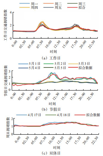
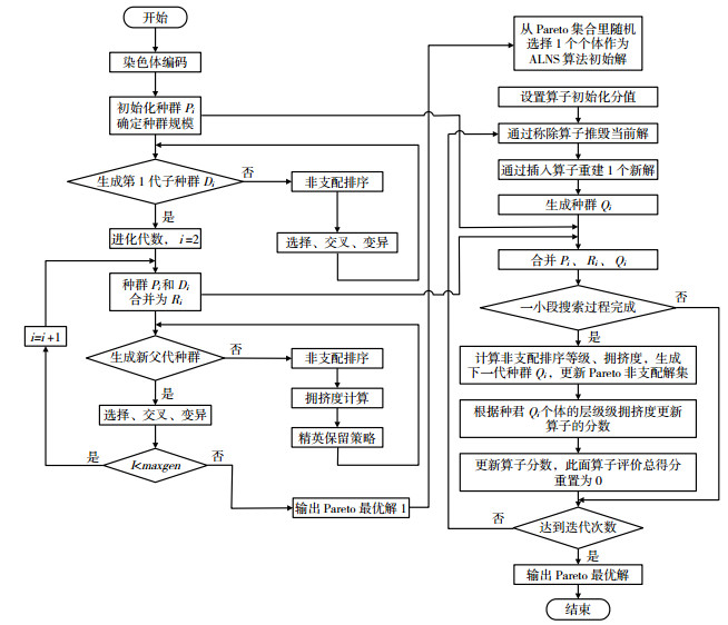
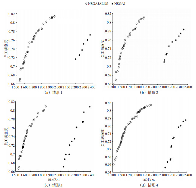
Considering increasing traffic congestion in urban areas, routing problem of vehicles serving the cold chain logistics is modeled as an optimization problem with multiple objectives (namely delivery cost and satisfaction of customers and deliverymen), which is expected to provide solutions to the punctuality and satisfaction issues within the cold chain logistics industry. Traffic data on weekdays, holidays, and weekends are collected, the temporal distribution of the congestion is studied, and a model for estimating travel time among different nodes within road network is also developed. A gray-whitening weight function is used to evaluate the satisfaction of deliverymen by considering workload and salary. A multi-objective vehicle routing problem is modeled with the following constraints, including stochastic demand, customer satisfaction, time windows, and others. An improved adaptive large neighborhood search (IALNS) algorithm is proposed, which balances the searching scale and computational time of the non-dominated sorted genetic algorithm-II (NSGA-II). The results of the proposed method in the classical Sioux-Falls transportation network are shown as follows: ①When the deliveryman's satisfaction is considered, the total cost of delivery on working days, holidays, and weekends increases by 2.05%, 1.93%, and 1.16%; the deliveryman's satisfaction increases by 39.43%, 46.26%, and 57.37%; the average customer satisfaction increases by 1.16%, 4.76%, and 9.75%; and the transportation time decreases by 2.42%, 7.34%, and 8.41%, respectively. ② When the total cost is set as the main objective andthe standard deviations of customer demand are set as 1, 2, 3, 4, and 5, the shortage cost increases by 0.79%, 0.89%, 0.93%, 0.94%, and 0.95%, respectively, compared with the case without considering the stochastic demand. Study results show that the stochastic demand from the customers has an impact on distribution costs. In conclusion, the proposed model and algorithm can provide a new methods for improving satisfaction of deliverymen and customers of cold chain logistics industry.
The Effect of the Terrain Slope of Mountainous City on Car Ownership: A Case Study of the City of Guiyang
XIONG Renjiang, ZHAO Hang, DUAN Meihua, HUANG Yong, WEI Wei, LIU Siming
2022, 40(5): 169-180. doi: 10.3963/j.jssn.1674-4861.2022.05.018
Abstract(529) HTML (174) PDF(20)
Abstract:
To analyze the effect of the terrain slope of mountain cities on car ownership of residents, and to study the effect of perception of residential environment on car ownership under different terrain slopes, three observed variables are introduced to evaluate the effect based on the survey data collected from residential areas with different slopes in the downtown area of the City of Guiyang. In this regard, SEM-Logit models with latent and explicit variables are developed to study the effect of perceived and objective built environment on car ownership by incorporating adaptation values of latent variables into logit models. Study results show that the perception of terrain has an effect on the car ownership. Under the scenarios where the terrain slope of the neighborhood is less than 8%, the distance and time cost of walking to public transportation stations in the neighborhood is considered to be within their tolerance and the perception of terrain does not significantly affect car ownership. When the slope is between 8% and 15%, the perception of terrain has a significant negative effect on car ownership. Residents in these areas, especially those with a low income, prefer to travel by electric bicycles, which is found to significantly reduce the car ownership. When the slope is greater than 15%, there is a positive correlation between terrain slope and car ownership. Frequent uphill and downhill roads cost residents a higher travel time in these areas. This severely reduces the likelihood that residents choose walking or cycling, which in turn increases the probability of car ownership. Moreover, it is found that annual household income, closest distance to subway station, mixed land-use, accessibility of destination, and travel attitude all have a significant impact on the car ownership.
2022, 40(5): 181-184.
Abstract(241) HTML (208) PDF(20)
Abstract: