2021 Vol. 39, No. 5

Overview
An Overview of Traffic Management in "Automatic+Manual" Driving Environment
PEI Yulong, CHI Baiqiang, LYU Jingliang, YUE Zhikun
2021, 39(5): 1-11. doi: 10.3963/j.jssn.1674-4861.2021.05.001
Abstract(4493) HTML (1453) PDF(573)
Abstract:

Based on the development status of "automatic driving vehicle", the problems existing in mixed driving environment of autopilot cars are analyzed to understand the current situations and development trends of traffic management in the mixed driving environment. In terms of the Citespace bibliometric tool, the CNKI core database in the past 24 years(1997—2020)is taken as the data source. The bibliometric and visual analysis are performed from publication year, journal source, research institution, and keywords, and network maps of relationships between research institutions and keyword co-occurrence is generated. The results show that the number of automatic driving documents has been increasing in China in recent 5 years. The journal with the most of related papers is China Journal of Highway and Transport. Its research directions of the automatic driving vehicles include: ①Research on target detection and scene perception. ②Research on decision making and control. ③Research on responsibility delineation of traffic accidents. In the future, for mixed driving environment, traffic management should combine vehicle-road coordination and high-precision map technology, study from the design of signs and markings, signal timing optimization, ownership of road rights, and the delineation of traffic accident responsibilities, thus making road transportation safe, efficient and convenient.

Transportation Safety
An Analysis of Highway-traffic Safety Based on Dynamic Risk Saturation
TIAN Wanli, WU Zhongguang, LI Juan, HU Shaohong, SUN Xiaojun
2021, 39(5): 12-18, 42. doi: 10.3963/j.jssn.1674-4861.2021.05.002
Abstract(2924) HTML (655) PDF(135)
Abstract:

The study proposes a dynamic risk saturation theory and constructs a dynamic risk saturation model and a calculation method to reflect the safety operation status of highways. On the basis of the driving behavior of vehicles under different traffic saturation of the road section and the constraint of keeping the road section traffic safety, the calculation method of the average minimum safe headway of the road section takes into account the influence of vehicle speed changes and special weather conditions, such as vehicle speed and foggy in the two driving states of car-following and lane-changing. The established conversion relationship between safe headway and safe flow, is used to obtain the safe flow of road sections under different driving conditions. Under the switching thresholds of different driving states, the ratio of the actual traffic flow to the safe flow of the road section is calculated to obtain the dynamic risk saturation values for road sections. Taking a road network of a reconstructed and expanded section of the G3 expressway as a case study, the study calculates the dynamic risk saturation values of each section in the road network under different switching thresholds. It can be concluded that with the traffic saturation increases, the dynamic risk saturation shows a steady pattern of first increasing and then decreasing. It reaches the maximum in lane-changing driving state and starts to decrease in the following driving state, which is consistent with the existing analysis of traffic safety states. Compared with the factor of traffic saturation, dynamic risk saturation can better indicate the pattern of dynamic changes in traffic safety of highway sections.

A Risk Assessment Method of LTE-R System Based on Improved Evidence Theory
GAO Yu, WU Xiaochun
2021, 39(5): 19-26. doi: 10.3963/j.jssn.1674-4861.2021.05.003
Abstract(308) HTML (240) PDF(23)
Abstract:

A method based on AHP and improved evidence theory is proposed to evaluate LTE-R system, thus solving the problem of differences and conflicts of subjective evaluation of experts in operational security risk assessment of LTE-R system. Fuzzy mathematics is used to transform fuzzy evaluation of experts into quantitative membership degree. Adopting the improved evidence theory, the process of overcoming conflicts between evidences can be improved based on Pearson coefficient. Through the weighted distribution of evidence credibility weights, the subjectivity of information is improved. Conflict factors are constructed to modify the evidence fusion process, and the basic probability assignment(BPA)function matrix is finally obtained. The maximum membership degree is selected as a judgment principle to evaluate the risk level of the corresponding system, then compared with other methods. It can be summarized that the evaluation of the case analysis of the LTE-R system is "negligible risk" with a confidence level of 83.41%, which is 3.12% higher than the discount evidence theory, and 16.95% higher than the grey-fuzzy security assessment method. Under the premise of consistent evaluation results, the method can improve the problems of expert evaluation conflicts that cannot be handled correctly and integration, and provide a high-confidence risk level value, which provides a reference for the operation evaluation of the LTE-R system.

An Evolutionary Game Model of Traffic Conflict Between Electric Bicycles and Pedestrians in Bus Stop Areas
ZHOU Dan, YAO Weizhen, GU Guobin, HU Qingwei
2021, 39(5): 27-35. doi: 10.3963/j.jssn.1674-4861.2021.05.004
Abstract(3028) HTML (539) PDF(209)
Abstract:

The work studies the selection mechanism of travel strategies of pedestrians and electric bicycles when the two parties conflict in bus station areas. A time delay model of pedestrians and electric bicycles is established to analyze the time profit of two types of travelers choosing whether "passing" or "crossing" strategies. The replication dynamic equation is used to describe the game learning behavior of the two types of travellers' general strategy, and to establish the conflict evolution game model between the two types of travellers in this area. The stability analysis is used to obtain a stable behavior selection strategy of conflicts between two types of travelers in the region. The evolutionary game model is empirically analyzed by the measured data of six bus stop areas in Guilin. The results show that the proportion of pedestrians choosing to "passing" increases when the sense of security increases. When conflicts occur, electric bicycle riders make decisions faster than pedestrians. The decision-making time for both parties to choose "passing" or "crossing" is shorter than "waiting" or"deceleration". The average decision-making time of electric bicycles reduces by about 23%, and that of pedestrians reduces by about 24%.

Application of Comparative Safety Methods in Civil Aviation Safety Management Models
SUN Junya, SUN Ruishan
2021, 39(5): 36-42. doi: 10.3963/j.jssn.1674-4861.2021.05.005
Abstract(477) HTML (446) PDF(44)
Abstract:

The work, based on the method of comparative security, compares the SHELL model and REASON model in ICAO safety management manual to study the references development of models in civil aviation safety management. On the premise of the research mode of comparative security, two three-dimensional comparative models based on the time dimension, knowledge dimension, and space dimension are constructed. From the perspective of time dimension, the work mainly compares the development ideas and evaluation emphases of the two models. The differences between the two models in components and functions are analyzed from the knowledge dimension. Through the application field of the spatial dimension, the scope of application of the two models is the research focus. In conclusion, both models have similar application fields and values in civil aviation safety management, but there are differences in the emphasis of risk analysis, path analysis, and scope analysis. In terms of different requirements of security management, the two models have different advantages. Therefore, the further application of the model and the development of new models can draw on the advantages of the two models.

An Analysis of Injury Severities in School Bus Accidents Based on Random Parameter Logit Models
SHI Ying, PAN Yiyong, WU Jingting
2021, 39(5): 43-49. doi: 10.3963/j.jssn.1674-4861.2021.05.006
Abstract(3801) HTML (700) PDF(154)
Abstract:

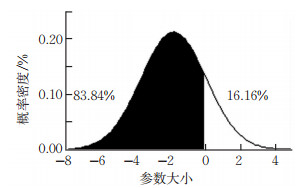
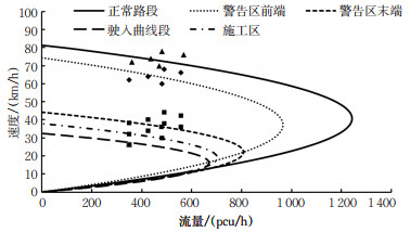
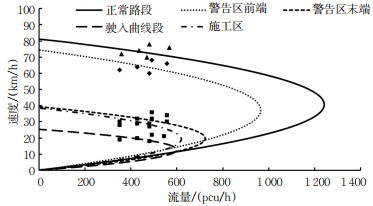
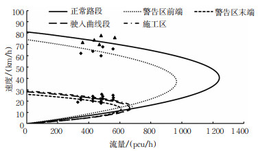
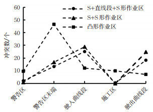
This study develops an injury severity prediction model for the accidents involving school buses based on random parameter Logit model, in order to analyze the impacts of relevant factors on the injury severity of school bus accidents and the heterogeneity that is not observed in the accident data. The independent variables are from the following aspects: driver, vehicle, road characteristics and environment. It is found that: ①under the assumption that the corresponding parameters of the two involved vehicles follow the normal distribution, the probability of not having fatal and injury accidents of the school bus is 83.84%. ②The probability of a fatal injury is reduced by 0.58% when the driver is between 35 and 44 years old and the number of vehicles involved is one. ③When the road speed limit is between 40 and 50 km/h, the probability of injuries and fatal crashes increases by 0.35%;when the road speed limit is greater than 60 km/h, it increases by 0.96%. ④When the airbag is triggered, the probability of injuries and fatal crashes increases by 2.35%. ⑤When the traffic control mode is lane markings, the probability of possible injury accidents increases by 1.85%;when the control mode is the central divider, it decreases by 1.44%, while the probability of injuries and fatal crashes increases by 0.48%. ⑥The probability of possible injury accidents decreases by 0.42% when reversing turns under unsafe conditions; the probability of uninjured accidents increases by 1.36%, 0.56%, 0.39%, and 0.97%, respectively as distracted driving, missing lane driving, being too close to cars, and other factors(i.e. drinking), but the probability of accidents involving possible injury, and fatal crashes reduces.

Transportation Information Engineering and Control
An Image Generation Method for Automated Driving Based on Improved GAN
SUN Xiongfeng, HUANG Zhen, CHEN Zhijun, LUO Peng
2021, 39(5): 50-58,75. doi: 10.3963/j.jssn.1674-4861.2021.05.007
Abstract(3799) HTML (487) PDF(300)
Abstract:

There is a huge demand for driving images in the automated driving systems based on end-to-end data system. In order to solve the instability of general generative adversarial network model and the lack of diversity of generated image features when expanding the driving image data set, this work proposed an improved network model, LS-InfoGAN. The least-squares loss is used to prevent the model gradient from disappearing and alleviate the contradiction in the generator during optimization, thereby improving stability of the model. The learning ability of the generator is improved by maximizing mutual information between generated images and actual images, thus improving the diversity of its features. The transposed convolutional layer to restore the image features is used to improve the clarity of the generated image features. The effectiveness and application performance of the model are verified with a labeled image dataset acquired in self-built driving scenes. According to the academic analysis in this study, compared with the model before the improvement, the stability of the image generation process of the LS-InfoGAN model is improved by an average of 35%。Besides, when used for training in the decision network of end-to-end self-driving systems, the augmented dataset can improve the decision performance by 1% to 2% without acquiring new images. The recommended number of generated images is 1 to 2 times the number of original images when the model is used to augment the dataset.

Simulation of Vehicle Following Platoons at Cut-in Scenarios Based on Natural Driving Data
LU Guangquan, LI Yilin, LI Penghui
2021, 39(5): 59-67. doi: 10.3963/j.jssn.1674-4861.2021.05.008
Abstract(628) HTML (277) PDF(48)
Abstract:

Vehicle cut-in is a frequent lane-changing behavior, which has a significant impact on traffic efficiency and safety. Therefore, studying driving behavior at the cut-in scenarios is of great significance for disclosing the mechanism of traffic congestion and driving safety. Based on a natural driving dataset collected for this study, driving conditions of the cut-in behaviors are analyzed based on drivers'subjective risk perceptions. A desired safety margin (DSM)model is used to calibrate the relevant parameters under the cut-in scenario, and a following platoon simulation at the cut-in scenarios is developed according to the calibrated results. During the simulation study, it is found that the differences in platoon length, vehicle speed, and cut-in position all affect the stability and adjustment of the platoon. When the number of vehicles in platoon increases from 4 to 13, and their speed increases from 5 to 20 m/s, and the position of the cut-in vehicle changes from close to the front and rear vehicles to the middle of the two vehicles, it is found that the cut-in behavior presents a reducing impact on the stability of the platoon, which also facilitates the platoon returning to a stable state.

Active Traffic Guidance Method for Recurrent Congestion Points
LUO Shulin, ZHANG Cunbao, ZHANG Taiwen, CAO Yu
2021, 39(5): 68-72. doi: 10.3963/j.jssn.1674-4861.2021.05.009
Abstract(389) HTML (163) PDF(49)
Abstract:

Traffic guidance methods based on dynamic user equilibrium and optimal system allocation focus on macro forecasting and adjustment of road network demands. They are difficult to accurately identify related traffic flow, which restricts the guidance effects. An active traffic guidance method based on traceable demand is proposed to control traffic flows and alleviate recurrent congestion. The study following the idea of targeted guidance, analyzes the correlation between vehicle trajectory and traffic flow at frequent congestion points, and uses Kalman filter to make short-term predictions of the associated traffic flow. Furthermore, it is preferable to optimize target traffic flows in combination with indicators such as traffic ratio and path saturation. Meanwhile, based on balanced traffic distribution, the spatio-temporal correlation between the road section and the path traffic flow is used to update the road network traffic state and establish an active induction optimization model with saturation equilibrium as the goal. The simulation results show that, compared with the active induction based on path preference, this method result in a reduction from 30% to 60% in the average delay and the number of stops of vehicles at frequent congestion points, and a reduction from 10% to 15% in the whole road network. The convergence speed and traffic benefit of the model are significantly improved, which verifies the effectiveness of the method in the work.

Fundamental Diagram and Stability Analysis of Heterogeneous Traffic Flow in a Connected and Autonomous Environment
MA Qinglu, FU Baoyu, ZENG Haowei
2021, 39(5): 76-84. doi: 10.3963/j.jssn.1674-4861.2021.05.010
Abstract(641) HTML (252) PDF(43)
Abstract:

This work focuses on the impacts of heterogeneous operation of manual driving vehicles and connected and autonomous vehicles(CAVs)on traffic flow. The fundamental diagram and stability of such traffic flow are set as the key technologies and methods to improve its operation. First, the full velocity difference model(FVDM)is selected as the car-following model of manual driving vehicles. Secondly, the cooperative adaptive cruise control(CACC)model calibrated with real-world vehicle location data from the University of California at Berkeley is used as the car-follow⁃ ing model of CAVs. Third, a fundamental diagram model of heterogeneous traffic flow is then developed to study the influence of CACC vehicles on road capacity and to compare the impacts of different manual driving models on hetero⁃ geneous flow capacity. In addition, based on the traditional research method of heterogeneous traffic flow consisting of vehicles of different sizes, the traditional car-following model is used to develop a stability analysis method for the het⁃ erogeneous traffic flow under study, and the stability analysis under different CACC ratios is carried out by Matlab. Study results confirms that, compared with the homogeneous manual-driving traffic flow, the road capacity under the homogeneous CACC traffic flow will be increased by about 95% and different manual driving models in the experiment has little impact onto the capacity. When the equilibrium speed is set at 15 m/s, a low proportion of CAVs(e.g. below 20%)won't improve the stability of traffic flow. On the other hand, when the proportion of CAVs reaches 20% and above, the heterogeneous flow gradually shows an increasing stable trend with an increased proportion of CAVs. It is al⁃ so found that, when the proportion of CAVs reaches 70% and above, traffic flow basically will maintain its stability.

Optimization Control of Dynamic Use of Exit-lanes for Left-turn Traffic
YANG Xiaofang, WANG Ying
2021, 39(5): 85-92. doi: 10.3963/j.jssn.1674-4861.2021.05.011
Abstract(208) HTML (120) PDF(27)
Abstract:

The design of dynamic use of exit-lanes for left-turn(EFL)traffic has been applied to many urban intersec⁃ tions. The existing EFL design and traffic control schemes are improved to solve the problems of uneven distribution of traffic flow in different lanes and low utilization rate of countercurrent lane during certain periods. A new method of the dynamic EFL design and flexible configuration is proposed. Based on the optimized length of the improved dynam⁃ ic EFL, a signal control strategy is proposed and a delay estimation model under the unconventional EFL design is al⁃ so developed. Matlab is used to compare the signal control schemes under the three scenarios: conventional setup, be⁃ fore, and after improvement. It is found that, when the left-turn flow is 400 vehicles/h, the best signal cycle of conven⁃ tional intersections should be 130 s. Under the same signal cycle, compared with the conventional and the after-im⁃ provement scenarios, the vehicle delay is found to decrease by 39.68% and 29.48%, respectively. It is also found that, when the left-turn flow reaches 500 vehicles/h, the optimal cycle of the conventional intersection is found to be 174 s. When compared with the conventional and the after-improvement scenarios, the vehicle delay is found to de⁃ crease by 12.90% and 12.02%, respectively.

Aircraft Sequencing Modeling and Algorithm for Shared Waypoints in Airport Group
WANG Lili, LIN Yongya
2021, 39(5): 93-99,136. doi: 10.3963/j.jssn.1674-4861.2021.05.012
Abstract(226) HTML (163) PDF(29)
Abstract:

Congestion often occurs on shared waypoints due to shared airspace resources in airport group and compli⁃ cated operation coupling. The work studies sequencing optimization of the shared waypoint in the airport group to alle⁃ viate the problems of airspace congestion and flight delays. Aiming at the operating characteristics of a shared way⁃ point, penalty factors are adopted to minimize the total delay time cost as the optimization goal, and a model is devel⁃ oped to optimize aircraft sequencing on the shared waypoints in the airport group. Based on the principles of sliding time window algorithm and particle swarm optimization algorithm, a TW-PSO combined optimization algorithm is pro⁃ posed to solve the model. The aircrafts of the Beijing-Tianjin-Hebei airport group passing the shared waypoints are se⁃ lected for a simulation. The results show that the total delay time cost of the TW-PSO combined optimization algorithm in peak hours compared with the FCFS algorithm, sliding time window algorithm, and particle swarm optimization algo⁃ rithm, reduced by 216, 212, and 161 min, respectively. Therefore, in terms of algorithm performance, it has the advan⁃ tages of fewer iterations and better optimization outcomes than classic algorithms, which can alleviate flight delays and improve the coordinated operation of the airport group.

Transportation Planning and Management
Traffic Characteristics of Fully Enclosed Bypass Areas of Reconstruction and Extension of Two-lane Highways
MENG Xianghai, QIN Leilei, PAN Chenyue, ZHANG Longzhao
2021, 39(5): 100-107. doi: 10.3963/j.jssn.1674-4861.2021.05.013
Abstract(297) HTML (72) PDF(21)
Abstract:

In order to study traffic characteristics of the S + straight-line section + S-type bypass area, S + S-type by-pass area, and convex bypass area in reconstruction and expansion of two-lane highways, a field study is carried out for collecting traffic volume data and statistically analyzing speed variation of the three bypass areas. Then, the free flow speed and actual capacity of the main sections of the detour areas are calculated, in accordance with the calibration of the speed-flow conic model, and a simulation study for the traffic conflicts in the detour areas is carried out using Vissim. Study results show that the traffic bottleneck sections of the S + straight-line section + S type and S + S type bypass area appear in the driving curve section, while the bottleneck section of the convex bypass area presents at the end of the warning area. The average speed of the bottleneck sections in the three types of bypass areas is about 70% lower than that of the normal upstream sections, and the traffic capacity is reduced by about 50%. There is little difference in the traffic conflicts among the three types of bypass areas at low-volume flow. When the flow increases to above 500 pcu/h, the degree of traffic conflicts in the convex bypass area is much more serious than that of the other two types. In terms of comprehensive capacity, traffic efficiency, and traffic safety level, S + straight line segment + S-type bypass area is found to be more suitable than the others.

An Analysis of Vehicle Operating Characteristics of Deceleration Strips on Mountain Roads
WANG Siqi, PAN Cunshu, Zhang Heshan, XU Jin
2021, 39(5): 108-116. doi: 10.3963/j.jssn.1674-4861.2021.05.014
Abstract(240) HTML (80) PDF(20)
Abstract:

An actual vehicle test is carried out at Jiangnan Interchange in the main urban area of Chongqing to study the influence of deceleration strips on vehicle operation on mountainous roads.The collected data of vehicle speed and acceleration is to analyze operation characteristics on the test road section.The results included that: ① The speed distribution bandwidth reaches a minimum value at about 40 m on both sides of the deceleration strips, and the speed bandwidth rebounces at the positions of deceleration strips, which indicates that there is a large difference in the vehicle speed at the location of the deceleration strips and is prone to a rear-end collision risk.② The deceleration strips have a strong effect on the speed selection behavior of drivers: the closer the two deceleration strips are to each other, the stronger the effect on the drivers'behaviors, and the better the deceleration effects.③ The greater the initial speed before passing the deceleration strips, the longer the required length of deceleration strips; meanwhile, the earlier the deceleration measures should be taken.The 85th percentile deceleration and acceleration length are 225 and 212 m, respectively.④ The acceleration and deceleration of the vehicle through the deceleration strips are closely related to the initial braking speed and the initial speed before acceleration.The more complex the road environments, the more significant the differences between deceleration and acceleration curves when the vehicle passes through the deceleration strips.⑤ The upper limit of speed reduction rate for vehicles can reach 0.9, and the lower limit rate increases with the increased initial speed.

Adaptability of Kalman Filter for Short-time Traffic Flow Forecasting on National and Provincial Highways
SHEN Leixiao, LU Yuhang, GUO Jianhua
2021, 39(5): 117-127. doi: 10.3963/j.jssn.1674-4861.2021.05.015
Abstract(490) HTML (178) PDF(35)
Abstract:

The forecast of short-term traffic flow is one of the significant technologies to improve safety of national and provincial highways. General national and provincial highways have the characteristics of wide distribution and complex conditions, which requires good adaptability of short-time traffic flow forecasting methods. However, there are few systematic studies on this adaptability and associated mechanism. Out of many forecasting algorithms of short-term traffic flow, the adaptive Kalman filter algorithm is selected to investigate adaptability and its adaptive mechanism. The empirical analysis is conducted using traffic flow data collected from 8 traffic survey stations of the national and provincial road network in Xuzhou, Jiangsu, China. Under different traffic flows, the average absolute percentage errors for mean prediction of the selected algorithm ranged from 10.98% to 15.92%. Furthermore, the invalid coverage of the interval generation ranged from 5.21% to 6.15% under different traffic levels. The results indicate the selected adaptive Kalman filter algorithm has good overall performance under different traffic levels. After analyzing the parameters of the selected algorithm, it can be found that the algorithm parameters can be adjusted automatically with the change of traffic flow level, presenting a good adaptive mechanism; in the early stage of prediction, the selected algorithm can achieve effective performance adjustment and convergence.

Demand Forecasting of Taxi Travel Based on GPS Data
SUN Lishan, JIA Lin, WEI Zhonghua, LI Junfeng
2021, 39(5): 128-136. doi: 10.3963/j.jssn.1674-4861.2021.05.016
Abstract(693) HTML (396) PDF(66)
Abstract:

In recent years, the number of "car-hailing" keeps increasing, which leads to several problems gradually, such as long waiting time of "car-hailing"and large demands for hot spot areas. The experiences of "car-hailing" should be improved urgently. Based on GPS data of taxis in Chengdu, the distribution characteristics of taxi trips are studied by dividing working days into morning, evening, and night peak periods. A k-distance curve is used to improve the density-based spatial clustering of applications with noise(DBSCAN)algorithm. Cluster analysis is carried out on taxi pick-up and drop-down points, and the hot spot areas are obtained by data mining. The BP neural network is used to predict the travel demands in hot spot areas. The prediction results show that compared with the random forest model and ridge regression model, the MAPE of the BP neural network model increases by 3.25% and 5.87% in the morning peak, 2.98% and 4.32% in the evening peak, and 1.44% and 2.58% in the night peak, respectively, which verifies the feasibility of the BP neural network in demand forecasting of taxi travel.

Optimization of Single-berth Curbside Bus Stops Considering Impacts of Non-motorized Vehicles
LI Yingshuai, MA Zechao, WANG Wenjing, WANG Weijie
2021, 39(5): 137-143. doi: 10.3963/j.jssn.1674-4861.2021.05.017
Abstract(305) HTML (114) PDF(31)
Abstract:

Single-berth curbside bus stops are optimized to reduce the impacts of non-motorized vehicles on traffic flows around the bus stops along with sidewalks. Six single-berth curbside bus stops in the City of Chongqing are selected for case studies, with the analysis of the correlation among parameters including non-motorized vehicle lane width, length of bus stop, equivalent traffic volume, non-motorized vehicle speed, and three types of conflict rates(three types of rear-end conflict and horizontal conflict rates of non-motor vehicles and buses). In addition, regression models are developed in order to predict traffic conflicts. It is found that the prediction error of the prediction model is less than 10%. It is also found that when the width of the non-motorized lane is 3.5~4.0 m and the length of the single-berth curbside bus stop is 16~18 m, the conflict rate of the three types is the lowest. When the equivalent traffic volume reaches 700 pcu/h, the conflict rate becomes stable, and the speed of non-motorized vehicles should not be more than 6 m/s. Two bus stops are selected to predict the conflict rate and evaluate their safety levels. The lowest value of the conflict rate is used as a constraint to optimize the linear single-berth bus stops along the sidewalk. It is believed that the conclusions of this study provide a theoretical basis for traffic management around bus stops and planning, and design of related facilities.

A Model of Gate Allocation for Parallel Multi-runway Hybrid Operation from the Perspective of Fuel-saving and Carbon Emission Reduction
WANG Chao, REN Yunhong
2021, 39(5): 144-152. doi: 10.3963/j.jssn.1674-4861.2021.05.018
Abstract(262) HTML (114) PDF(21)
Abstract:

The work aims to solve the problems of gate allocation caused by segregated and parallel operation mode and unreasonable runway-stand usage plan, and the high taxiing emissions of aircraft surface. A traditional model of gate allocation is used to study the influence of the multi-runway operation mode on a stand allocation plan. Based on cooperative operation between air traffic control and airport control center, as well as nearby take-off and landing operation mode, the work proposes a gate allocation model oriented to parallel multi-runway mixed operation. Introducing aircraft flight direction constraints and flight continuity constraints can reduce the use of gate allocation schemes—flights run across the airport's surface, which is an excessively long taxiing distance. The study takes the account the impacts of different engine fuel-flow rates on fuel consumption and carbon emissions of the allocation plan, so the an integer programming mathematical model is established to minimize fuel consumption, and the simulation verification is carried out based on the operation data of Tianjin Airport in typical periods. The results show that taxiing distance and carbon emissions of the optimized strategy are reduced by 11.9% and 13.3%, respectively, compared with the originally planned operation results. The taxiing distance and fuel consumption can be reduced by optimizing the use of stands at airports with multiple runways to achieve fuel-saving and emission reduction.