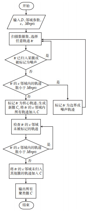
2021 Vol. 39, No. 6

Display Method:
A Decision-support System for Automated Collision Avoidance of Ships with Variable Speed Based on Simulation of Maneuvering Process
HUANG Liwen, LI Haoyu, LIANG Yu, ZHAO Xingya, HE Yixiong
2021, 39(6): 1-10. doi: 10.3963/j.jssn.1674-4861.2021.06.001
Abstract(3057) HTML (715) PDF(539)
Abstract:
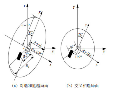
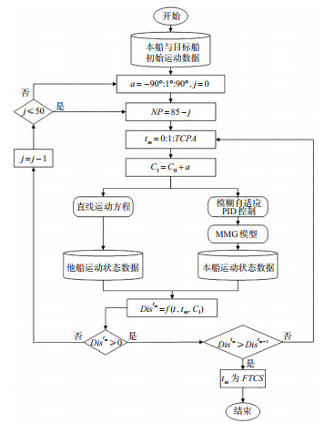
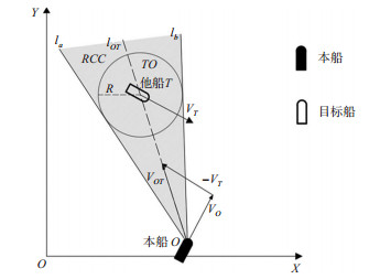
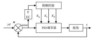
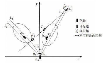
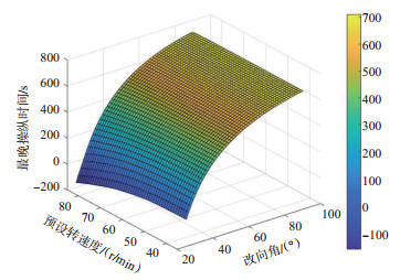
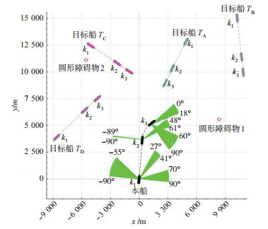
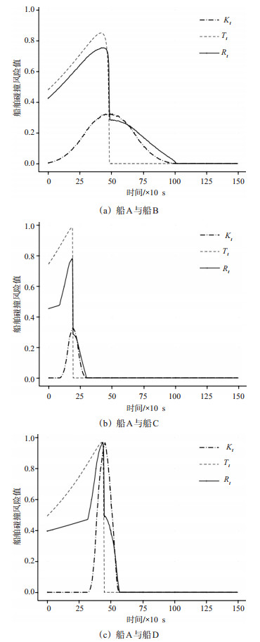
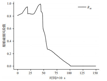
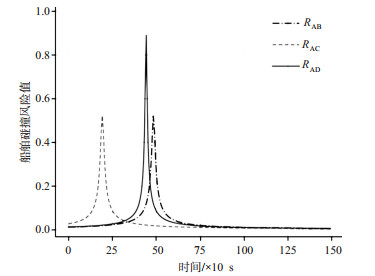
A decision-making method for variable speed automatic collision avoidance of ships in a multi-objective environment meeting the International Regulations for Preventing Collisions at Sea is studied to solve the problem of the poor effect of collision avoidance only by altering the direction in some scenes of ships. The risk of ship collision is quantified based on the four-stage theory of ship encounters and the ship domain model. The variable-speed MMG model and fuzzy adaptive PID heading control method are used to derive the ships' steering process at fixed and variable speeds. On this basis, an algorithm is improved for solving the dynamic feasible maneuvering interval based on the deduction of the maneuvering process and the speed obstacle theory. Combined with the actual scenarios, comparative experiments under different maneuvering schemes, simulations, and multi-objective scenarios are carried out. The results show that: ① The program running step length is set to 1 s. Under the pre-set position of other ship (4 n mile, 4 n mile), heading 270, speed of 12 kn, ship position (0 n mile, 0 n mile), heading 000, speed of 12 kn, the latest time point for maneuvering action to alter directions and speeds for yielding is 711 s. The latest time point for manipulative actions to be taken only by altering directions for yielding is 643 s, and that to be taken is delayed by 68 s. ② In a multi-object environment with distant objects, ship O driving to 663 s and keeping the speed and direction, which poses a collision risk with target ship TA, TC and TD. At this time, any combination of target course interval [48°, 61°] and rotation rate interval [75 r/min, 85 r/min] can clear all targets.
A Method for Estimating Dynamic Collision Risk of Vessels Considering Spatial-temporal Adjacency
LIU Zhao, CHEN Yang, ZHANG Mingyang
2021, 39(6): 11-18. doi: 10.3963/j.jssn.1674-4861.2021.06.002
Abstract(1110) HTML (592) PDF(616)
Abstract:
The catastrophe theory is used to propose a vessel collision risk calculation method considering spatial- temporal urgency to solve the limited applications of traditional risk-calculation methods in terms of ship collision in busy restricted waters. A model to calculate spatial urgency of vessel collision is proposed based on the numerical calculation of the superimposed area of the vessel domain. Then a model to calculate temporal urgency of vessel collision is also proposed considering vector relationships between relative position and relative speed of ships. Moreover, based on the catastrophe theory, a model to calculate collision risk of vessels is proposed, reflecting spatial-temporal urgency. The proposed models are validated by simulations, and compared with the models considering distance to the closest point of approach(DCPA), time to the closest point of approach(TCPA), and spatio- temporal distance-based collision risk assessment. The results show that the proposed vessel dynamic risk model in this work is more accurate in judging the collision risk, associated with the reflection of decreased changes in collision risk. This improvement avoids the drawback of a lacking description of nonlinear risk changes by other methods. The proposed model provides mariners with an accurate means to make decisions of vessel collision avoidance.
A Study of Prioritized Routing Strategy of Emergency Vehicles over Small-scale Emergency Scenes
HUANG Min, WU Zhaoju, LI Yetao, WANG Lingli
2021, 39(6): 19-26,53. doi: 10.3963/j.jssn.1674-4861.2021.06.003
Abstract(842) HTML (396) PDF(166)
Abstract:
For small-scale emergency scenes that take place during peak hours, the priority of emergency vehicle may cause traffic delays. And signal strategy to ensure the priority of emergency vehicle affects the reliability of route selection. A priority strategy of emergency vehicles based on a bi-level programming model is proposed, considering the efficiency of emergency vehicles and the delays to the traffic system. Path selection is affected by physical conditions and traffic status. Signal control changes traffic status. The lane group saturation is used as a parameter to characterize the traffic status, and a bi-level programming model for the priority of emergency vehicles is constructed. The upper-level is path selection, which can minimize the travel time of emergency vehicles. The lower level is signal control, which can maximize the social benefit caused by signal control. It is solved by an improved multi-labels algorithm for N-shortest paths problem. The result shows that the travel time of emergency vehicles is increased by 8.7%, but the delays of social vehicles are reduced by 261%. An increase of 1% in the travel time of emergency vehicles leads to a decrease of 30% in delays to the traffic system. This strategy can reduce larger delays to the traffic system at the cost of smaller delays to emergency vehicles.
An Analysis of Severity and Heterogeneity of Pedestrian Traffic Accidents Under Low Visibility Environment
DONG Aoran, QIN Dan, WANG Zhangshuai, ZHU Zishuo, ZHU Tong
2021, 39(6): 27-35. doi: 10.3963/j.jssn.1674-4861.2021.06.004
Abstract(1006) HTML (522) PDF(88)
Abstract:
This work studies the factors affecting the severity of pedestrian accidents under low visibility levels and investigates the possible heterogeneity. Taking 6 405 motor vehicle-pedestrian accidents in a city as the object, a random parameter Logit model with heterogeneity in means is established to investigate the factors influencing the severity of pedestrian injuries under high and low visibility levels. Elasticity analysis is used to quantify the influences of significant variables on pedestrian injuries. The results show that there are significant differences in the factors affecting severity of the pedestrian injury under high and low visibility.(1) Male drivers, elderly pedestrians, trucks, asphalt roads, early morning hours, and dark lighting conditions increase the severity of pedestrian injuries under low visibility.(2) Trucks and early morning hours have random parameters under low visibility, which increases the probability of pedestrian death by 4.39% and 2.67%, respectively. Besides, accidents involving trucks and pedestrians at the age from 26 to 35 will increase pedestrian fatalities, and its probability decreases as the combination of street lighting and early morning hours.(3) No heterogeneous factors are found under high-visibility conditions; however, factors such as male pedestrians and motorcycles are found to increase the severity of the accidents. Additionally, factors such as the age of the driver, asphalt road, weekend, and terrain have no significant impact on the severity of the accident.
An Analysis of Traffic Accident Severity Based on Mutual-information Bayesian Network
LYU Tongtong, ZHANG Zhan, LU Linjun, ZHANG Yanmeng
2021, 39(6): 36-43. doi: 10.3963/j.jssn.1674-4861.2021.06.005
Abstract(1049) HTML (516) PDF(178)
Abstract:
The methods of mutual information and Bayesian network are conducted to develop a model to grasp the factors affecting the severity of accidents in the inter-provincial bus industry. The quantitative interaction between changes in factors and the severity of accidents are analyzed. Given the limitation of the samples' size of the industry and the subjectivity of experts' knowledge of modeling, an improved discrete algorithm is used for data mining.A primary network construction method combining mutual information and cross-validation is proposed. Taking model analysis with 741 inter-provincial bus accidents in Shanghai from 2005 to 2019 as a case study, the results show that the most sensitive influencing factors of accidents are gender, weather, and vehicle type."Female driver""snow, wind, and fog""medium-size bus"account for 13.5%, 8.8%, and 5.7% of the weight of the accidents, respectively. Additionally, drivers' age has little contribution to the misfortune of group death and injury. Bus size has non-monotonic relationships with safety. The probability of more than seven people being injured during 00:00 to05:00 rises by 9%. The factors of season, weather, and time are not directly related to property loss. The generalization ability of the constructed model is better than other comparable models. The average AUC is 0.644 588, and the hit rate reaches 97.3%.
A Safety Analysis of LNG Ship-to-ship Transfer System Based on a STAMP/STPA Model
ZHU Mingchang, HUANG Liwen, XIE Cheng, SHI Feng, TAO Kejian
2021, 39(6): 44-53. doi: 10.3963/j.jssn.1674-4861.2021.06.006
Abstract(818) HTML (416) PDF(27)
Abstract:
Given the high risk and complexity of LNG ship-to-ship transfer operations, the safety problem of abnormal interaction of complex system components during operation is studied. A system-theoretic accident model and process(STAMP)control association model of the LNG ship-to-ship transfer system is constructed based on system theory and control theory splitting the ship-to-ship transfer system into multiple hierarchical structures to form constrained control and feedback. The system theoretic process analysis(STPA)method is adopted to identify system-level accidents, system-level hazards, and potential unsafe control behaviors in transfer operations. A causal scenario analysis model considering manual controllers is developed, and 22 causal factors in this system are proposed from system control defect, feedback defect, and coordination defect. The results show many potential causes in the LNG transfer system. Sensor system failure, control valve failure, and operator human factors are important causes of multiple system-level hazards, and safety control measures are proposed from the causal factors.This method is applied to the dynamic operation of ship transfer with a large number of interactions among people, software, and equipment, considering the non-faulty components in the system and overcoming the limitation of focusing on the failure of key components and excluding the dynamic behavior of the system.
A Detection Algorithm for Discovering Accompanying Relationship of Cruise Passengers Based on UWB Positioning
YAN Sixun, WU Bing, SHANG Lei, LYU Jieyin, WANG Yang
2021, 39(6): 54-62, 99. doi: 10.3963/j.jssn.1674-4861.2021.06.007
Abstract(762) HTML (465) PDF(46)
Abstract:
UWB positioning is used in the cruise to carry out an on-board personnel location experiment to discover the accompanying relationship among passengers in the interior space of a cruise. A improved scheme based on Haussdorff-DBSCAN is proposed combined with indoor positional semantics to study the clustering of the passenger trajectories, based on the characteristics of the UWB location data. Afterward, the LSTM neural network is applied to predict the changing similarity of the suspected companions. The traditional Hausdorff algorithm does not consider the consistency of trajectory timing while calculating the trajectory similarity, and the introduction of positional semantic sequence can solve this problem. In the first phase, the passenger trajectory data set is input to the improved Hausdorff-DBSCAN algorithm, and the clustering radius is determined according to the overall similarity threshold of trajectories. The outputs are the emerging clusters of passenger trajectories in the same companion group. In the second phase, the LSTM neural network takes the point similarity sequence with a fixed time window as the input to predict the point similarity value at the next time. The sequential change of passengers accompanying relationship is analyzed by the similarity threshold and predicted results. The validity of the presented algorithm is demonstrated by the trajectory data obtained from the simulation study, which is modeled in Anylogic. The results indicate that the precision of the proposed algorithm, the recall value, and the F1 value are 0.92, 0.95, and 0.934, which are at least 5.7%, 8.0%, and 6.7% higher than the compared algorithm, respectively. The LSTM neural network also shows a promising effect in predicting the changing trend of the similarity because the loss is at a stable level from 3% to 4%.
A Coordinated Control Method of Traffic Signals for Recurrent Congested Network Locations
ZHANG Taiwen, ZHANG Cunbao, LUO Shulin, CAO Yu
2021, 39(6): 63-72. doi: 10.3963/j.jssn.1674-4861.2021.06.008
Abstract(1120) HTML (551) PDF(67)
Abstract:
Traffic volume at recurrent congestion points is excessive, and the distribution of traffic load at associated intersections is unbalanced during peak hours. A coordinated control method of traffic signal for recurrent congestion points is proposed to solve the above problems. By tracking the traffic flow at the recurrent congestion point, the coordinated signal control area is determined according to a correlation of traffic volume. Then, the critical route of the coordinated signal control area is identified according to the traffic flow sharing rate and the average saturation of road sections. Based on the macroscopic fundamental diagram, an active perimeter control model considering the influences of critical routes on the state of road network is constructed. Meanwhile, a cell transmission model is used to describe the operating state of intersections and road sections. Maximum critical route capacity and equilibrium saturation of approaches are taken as the optimization objectives of signal control. A optimization model of signal control for balancing traffic load of road network is constructed. A simulation is carried out around the intersection of Wuhan Fazhan Avenue and Qingnian Road with its associated intersections. The results indicate that the average vehicle delay of boundary intersections increases by 6.8 s, but the average vehicle delay of the recurrent congestion point decreases by 15.7 s. The average vehicle delay decreases by 72.6 s, and queue length of the critical route decreases 26.1 m. Besides, the average vehicle delay of the road network is decreased by 14.7%, and the output traffic volume of the road network is increased by 26.6%.The simulation results verified the effectiveness of the proposed signal control method in alleviating traffic congestion at recurrent congestion points.
A Correction Algorithm for Course Errors from the Gyrocompass Along the Northeast Channel of the Arctic
WU Jianhua, DU Wei, WANG Chen, FU Peng, NIE Genzheng, JIANG Xinbo
2021, 39(6): 73-81. doi: 10.3963/j.jssn.1674-4861.2021.06.009
Abstract(763) HTML (308) PDF(23)
Abstract:
This work focuses on the problem of the decreased pointing accuracy caused by the reduced pointing torque in high latitudes when the gyrocompass commonly used on merchant ship is navigated in the Northeast Passage of the Arctic. Based on the historical data of the Northeast Passage of the Arctic, the influences of latitude and heading on heading error are considered. The least-square method is used to fit the heading error of GPS satellite compass and gyrocompass by the polynomial. Three fitting models are established to select the gyrocompass heading correction model with the smallest mean square error. When the GPS signal is abnormal, the model is used to correct the heading error of the gyrocompass. After correction, the accuracy of the gyrocompass heading remains within ±2.0°, and the correction rate within ±1° reaches 88.4%. When the GPS signal is normal, the Kalman filter is used for the second correction based on the first correction. The correction rate of the corrected gyrocompass heading accuracy within ±1.0° is 98.9%, and that within ±0.5° is 88.9%.
A Data-driven Method for Identifying Congestion State and Selecting Guided Vehicles for Urban Expressways
ZHAO Po, WU Ge, WANG Xiang, WANG Sihan, ZAN Yuyao
2021, 39(6): 82-90. doi: 10.3963/j.jssn.1674-4861.2021.06.010
Abstract(644) HTML (273) PDF(48)
Abstract:
The inefficient traffic guidance is that travelers are reluctant to accept a single guidance scheme due to heterogeneous travel characteristics. This work proposes an accurate selection method based on the travel characteristics to ensure guidance performance, thus alleviating the peak-hour congestion of the expressways. The congested sections are extracted from a traffic condition dataset of the Gaode map, and the original congested sections are identified according to the correlation of traffic conditions between the congested sections and its adjacent ones. Besides, the travel characteristics of vehicles passing on the expressways are extracted based on the license plate recognition data, including the travel intensity on the expressways, the travel intensity on the ground roads, the dispersion of expressway departure time, and the diversity of the expressway path selection. The travelers significantly affecting the traffic condition of the expressways are identified by the K-means++ clustering algorithm, and appropriate guidance(i.e. staggered shift and detour)is recommended to the identified travelers based on their traveling characteristics. Taking the Suzhou expressway as a case study, the traffic guidance for the original congested sections can improve the traffic condition of congested sections. Type-3 vehicles(high-intensity travel and easy to detour)are the key targets, accounting for only 14% of the total number of vehicles using expressways in the morning peak of working day in one month. However, they constitute 51% of the total traffic volume. There are 47% of vehicles that can be recommended with personalized traffic guidance after congestion-state identification and guided-object selection.
A Sensitivity Analysis of Lighting Condition Parameters in the Middle Section of Tunnel Based on Biomass Index
LIANG Bo, DONG Yue, YAN Zihai, LUO Jianqiang, NIU Jiaan
2021, 39(6): 91-99. doi: 10.3963/j.jssn.1674-4861.2021.06.011
Abstract(629) HTML (226) PDF(27)
Abstract:
A orthogonal experimental design is adopted to solve the lacking experimental research on light environment sensitivity in the middle section of tunnel under multi-factor conditions. Sixteen groups(4 factors and 4 levels)are set in this study. A model of the tunnel is established by Dialux simulation software. The simulation test is based on an indoor test platform for a dynamic driving test. In this test, three valid measurements of pupil diameter for each of the 30 test subjects are taken by SMI eye tracker, thus eliminating abnormal data. The composition parameters of the light environment are studied during driving in the middle of the tunnel. The effects of lighting arrangement, reflective coating height, reflective coating color, and LED light source color temperature on driver pupil diameter are studied. The relationship between primary and secondary factors is analyzed using the range and variance. The significance of the influences of various parameters on pupil diameter is obtained, which verifies the reliability of the indoor simulation. The results show that the test parameters selected in this study significantly affect the pupil diameter of the drivers. The influence degree is the lamp layout mode, LED light source color temperature, sidewall reflective paint color, and sidewall reflective paint layout height. According to the test results, the lamps are arranged along the centerline. The arrangement height of the sidewall reflective coating is 2 m, and the color of the sidewall reflective coating is white, with the color temperature of the LED light source of 4 500 K.
An Evaluation Study of Network Optimization through Connecting Dead-end-roads
HE Weitao, WANG Yandong, GONG Yanpeng, ZHAO Jian
2021, 39(6): 100-107. doi: 10.3963/j.jssn.1674-4861.2021.06.012
Abstract(692) HTML (369) PDF(435)
Abstract:
Dead-end-roads(DERs)are widespread in any city, and their presence can reduce the usage of roads and lead to traffic congestions. However, there are limited quantitative methods to assess the impacts of DERs. A new method is proposed to assess their impacts. At the level of road structure, community detection is used to classify the road network, and analyze the community which greatly affected by responded DERs. At the level of traffic assignment, whether a dead-end-road is opening, two simulations are performed in the community mentioned above. On this basis, the percentage change of the average value in roads' speeds is selected as an evaluation index. Then, this method is varified by a case study of the road network in Chaoyang District, Beijing. The results shows that: ①Under the travel demand of 900 pcu, the mean value of indices is less than 0.6%, indicating that opening DERs in the low-load area cannot bring obvious optimization. ② Under three groups of large travel demand, the mean value of indices of cross-community DERs(3.097%, 1.833%, and 2.633%)are higher than which of intra-community DERs(2.077%, 1.785%, and 2.041%). The opening of cross-community road sections should be given priority in municipal projects.
A Method Based on Point Fusion Procedure for Scheduling Arrival Flights on Multiple Runways
WANG Ning, ZHAI Wenpeng
2021, 39(6): 108-116. doi: 10.3963/j.jssn.1674-4861.2021.06.013
Abstract(550) HTML (239) PDF(438)
Abstract:
An optimization ranking model for multi-runway approach flight based on 0-1 integer programming is proposed considering the complex structure of terminal area arrival program under point merge system to improve the operation of approach flights at multi-runway airports based on a point fusion system. Different approach procedures and runways are assigned to different approach flights to determine the flight time and landing time of flights with the total delay time and total flight time of the approach flights as the minimum objective function, and the wake interval, runway limit, flight time range of the approach flights and assignable approach procedure as constraints. The landing sequence of flights is obtained. Taking the approach procedure of Pudong Airport as a case study, the non-dominated genetic algorithm containing elite strategy is selected to optimize the sequencing of approach flights for the double landing runway of Pudong Airport. Then compared the results with the actual results. The flight time and delay time of the optimized program is 51 048 and 1 174 s, respectively, which are 2.1% and 38.2% lower compared with the actual results, and the number of runway landing sorties per unit hour is increased by 7 while the runway flow is increased by about 20%.
A Study of the Effectiveness of Epidemic Prevention Policies on Public Transit Usage Based on the Theory of Planned Behaviors
ZHANG Xinming, GONG Di, XIE Binglei, MA Hang
2021, 39(6): 117-125. doi: 10.3963/j.jssn.1674-4861.2021.06.014
Abstract(814) HTML (401) PDF(489)
Abstract:
Epidemic prevention strategies play a key role in the decision behavior and travel preference. Thus they are related to the long-term effects of the"public transport priority"strategy. From the perspective of residents' travel behaviors, the influencing factors and travel paths on transit-trip behaviors are studied using the questionnaire and the theory of planned behaviors. Furthermore, epidemic prevention strategies of public transit are analyzed. A significant path of the influencing factors on transit-trip behaviors is found, namely"risk perception and epidemic prevention strategies → travel attitude → travel intention → travel behaviors". Thus, the perceived risk and prevention strategies of the epidemic have profound and long-term effects on choosing traffic modes as well as travel preference. Therefore, strict strategies, such as the shutdown approach, should be used more carefully. Further, by analyzing the observation variables, the path coefficients to the corresponding latent variables of the driver's information and the disinfection of the internal environment are maximum, more than 0.9. These indicate that releasing the implemented epidemic prevention strategies is vital to residents' traveling attitudes. However, it is generally ignored at present. Finally, based on the analysis results, some specific strategic suggestions are put forward, such as information disclosure and decentralized sitting.
A Validation Study of Interactive Stress Relationship Between Urban Rail and Regular Bus Transportation Systems
JIAO Liudan, LUO Fenglian, WU Ya, ZHANG Yu
2021, 39(6): 126-134. doi: 10.3963/j.jssn.1674-4861.2021.06.015
Abstract(680) HTML (336) PDF(248)
Abstract:
An interactive stress model of urban rail and conventional bus transportation is established based on the interactive stress theory traditionally applied to study the relationship between urbanization level and ecological environment. It is used to reveal the interactive relationship between urban rail and conventional bus transportation systems. Ten cities in China that have operated urban rail transit before Year 2009 are selected for a case study. The interactive stess relationship between urban rail and conventional bus transportation systems among the ten cities is verified through the following three indicators: passenger flow, the length of operating lines, and the number of operating vehicles. Then, the evolution pathways of urban rail transit and conventional public transport in different cities are classified. Study results of this paper show that: ① There is an interactive stress relationship between urban rail and public bus transportation systems, and the evolution trajectory can be best described using the double exponential curve. ② There is an imbalance between rail transit and conventional bus transport in different cities over their evolution pathways measured through the above three indicators. The inflexion point of the total passenger volume occurs earlier than the length of operating lines and the number of operating vehicles. ③ According to inflexion points, ten cities are divided into five categories. The inflexion points of Chongqing in the three dimensions are late, indicating that the development mode of public transport in Chongqing is relatively coordinated. Conventional public transport still maintains certain competitiveness under the stress of rail transit.
Flexible Returning/Parking Strategies for One-way Car-sharing Systems
LU Rongqin, ZHAO Xiaomei, LIU Binbin
2021, 39(6): 135-142, 179. doi: 10.3963/j.jssn.1674-4861.2021.06.016
Abstract(665) HTML (339) PDF(231)
Abstract:
In one-way car-sharing systems, there are not enough parking places for users to return cars in many cases. Two flexible returning/parking strategies are proposed to solve this problem: parking cars in temporary spaces and unoccupied spaces. In the former strategy, users are allowed to return cars to temporary parking spaces nearest to the car-returning stations. In the latter one, users are encouraged to park cars in available spots in the same zone as the car-returning stations. A mixed-integer nonlinear programming model is developed to maximize the profit of car-sharing companies. The big-M method is applied to convert the nonlinear constraints into linear constraints, and the commercial solver is used to solve the transformed model. A case study shows that parking in temporary spaces and unoccupied spaces can improve the profits of car-sharing companies. The maximal profit increasing rates are 25% and 37%, respectively. When the number of parking spaces is lower than demands, parking to temporary spaces performs well in improving the profits. Under the same circumstance, the more temporary parking spaces the company rent, the higher profits the company can obtain.
A Localization Method for Intelligent Vehicles Based on Semantic Map Representation Extracted from 3D Cloud Points
ZHU Yuntao, LI Fei, HU Zhaozheng, WU Huawei
2021, 39(6): 143-152. doi: 10.3963/j.jssn.1674-4861.2021.06.017
Abstract(704) HTML (291) PDF(28)
Abstract:
An intelligent vehicle localization method based on the semantic-map representation of 3D point clouds is proposed to improve the accuracy of node localization for intelligent vehicles. The method is divided into three parts. ① Semantic segmentation based on 3D laser point clouds includes segmentation of ground, traffic sign, and pole-shaped targets. ② Semantic-map representation for intelligent vehicles uses segmented targets to project. Directional projections with weight, semantic roads, and semantic coding are generated. The coding and global location from high-precision GPS make up the representation model. ③ Localization based on a semantic representation model includes coarse positioning from GPS matching and node localization from semantic coding matching. The experiments are performed in three road scenes with different lengths and complexities, and their localization accuracy is 98.5%, 97.6%, and 97.8%, respectively. The results show that the proposed method has high accuracy and strong robustness, suitable for different road scenes.
A Data Association Method Based on Tracking and Matching of Assisted Optical Flows from the Descriptor
XIA Huajia, ZHANG Hongping, CHEN Dezhong, LI Tuan
2021, 39(6): 153-161. doi: 10.3963/j.jssn.1674-4861.2021.06.018
Abstract(683) HTML (292) PDF(16)
Abstract:
The positioning accuracy of visual inertial odometer using multi-state constrained Kalman filter(MSCKF)is easily affected by mismatching points. A data association method is proposed for mitigating these outliers in this study. First, pyramid Lucas-Kanade(LK)optical flow is used to track and match the features among the sequence images. Second, the rBRIEF descriptors of each pair of matching points are achieved. Third, the Hamming distances between two rBRIEF descriptors can be calculated. Furthermore, the similarity of these descriptors is then evaluated according to Hamming distance. Last, the matching points of low similarity are eliminated as outliers in the data processing. The performances of the proposed method is assessed by the effectiveness of matching and positioning accuracy of the feature point. The results indicate that the proposed method can eliminate mismatching points in dynamic image processing. The outlier-eliminated images are applied for the MSCKF motion estimation. The derived drift rate of positioning result is less than 0.38% and shows an improvement of 54.7% with no outlier-eliminated MSCKF algorithm. The single-frame image processing time is about 39 ms.
A Cooperative Map Matching Algorithm for Intelligent and Connected Vehicle Positioning
CHEN Wei, DU Luyao, KONG Haiyang, FU Shuaizhi, ZHENG Hongjiang
2021, 39(6): 162-171. doi: 10.3963/j.jssn.1674-4861.2021.06.019
Abstract(698) HTML (313) PDF(29)
Abstract:
A cooperative map-matching algorithm based on adaptive genetic Rao-Blackwellized particle filter is studied for low-cost and high-precision vehicle positioning in the intelligent and connected vehicle environment.The accuracy of vehicle positioning is improved using the real-time location data and road constraints of other connected vehicles. The adaptive genetic algorithm is introduced into the re-sampling process of the particle filter, increasing the diversity of particles to solve the problems of"particle degradation"and"particle exhaustion"in traditional particle filters algorithms. The model of the algorithm is established and simulated. The positioning results under the traditional particle filter and Kalman particle filter are compared, with the influences of different connected vehicle numbers on the positioning accuracy analyzed. The experiment is completed in the real scene, and the performance of the algorithm is verified. The results show that taking a typical intersection with four connected vehicles as a case study, the range of position error of cooperative map matching is 1.67 m. It is only 41.03% and56.80% of the traditional GNSS and the single map matching positioning results, respectively. The circular error probable(CEP)of this algorithm is 1.06 m, which is 2.52 m higher than the raw GNSS positioning result.
A Visual Localization Method Based on Indoor Signs
HUANG Gang, CAI Hao, DENG Chao, HE Zhi, XU Ningbo
2021, 39(6): 172-179. doi: 10.3963/j.jssn.1674-4861.2021.06.020
Abstract(579) HTML (311) PDF(115)
Abstract:
A visual localization method is proposed to provide a way of localizing intelligent vehicles and mobile robots in indoor environment. The proposed method exploits various signs within indoor environment and uses the boosted efficient binary local image descriptor(BEBLID)algorithm. The proposed method enforces the ability to characterize the whole image by improving the classic BEBLID. The localization method consists of an offline and online component. For the offline component, a scene sign map is created. For the online component, the localization progress is divided into 3 parts. In the first part, the holistic BEBLID features are matched. The closet sign site and the closet image are located by using the KNN method. In the second part, the correspondences of key points are identified by local BEBLID features matching. In the third part, the current position is localized by metric calculation using coordinate information stored in the scene sign map. The experiment is conducted in three kinds of indoor scenes, including a teaching building, an office building, and an indoor parking lot. The results show that the recognition rate of signs in the scene reaches 90%, and the average localization error is less than 1 m. Compared with the traditional methods, the proposed method improves about 10% of relative recognition rate with the same test set, which verifies the effectiveness of the proposed method.