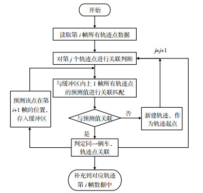
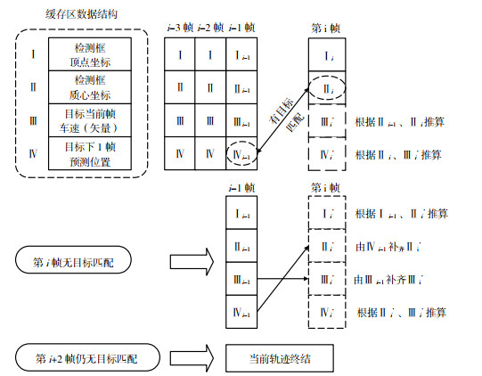
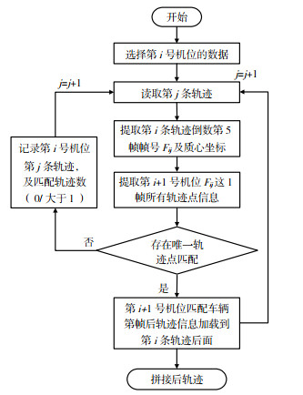
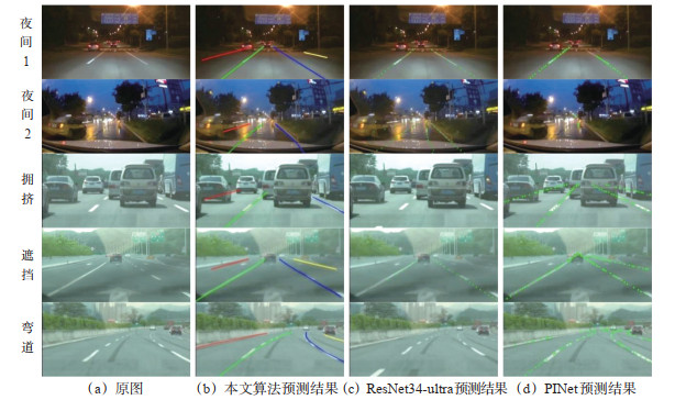
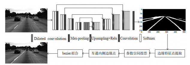
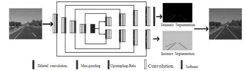
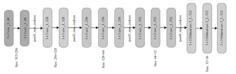
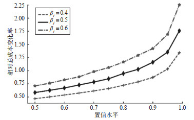
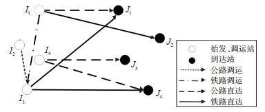
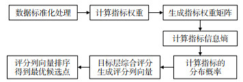
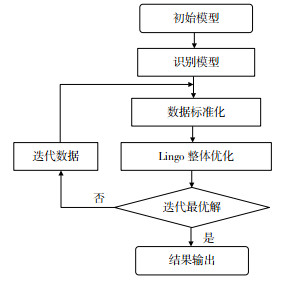
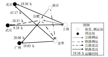
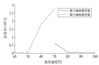
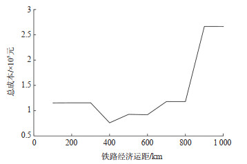
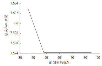
2023 Vol. 41, No. 3

Display Method:
2023, 41(3): .
Abstract(363) HTML (314) PDF(8)
Abstract:
An Analysis of the Mechanism of Traffic Conflicts Considering Risky Lane-changing Behavior in Weaving Sections of Expressways
LI Jiashuo, ZHENG Zhanji, GU Xin, XIANG Qiaojun, CHEN Gang
2023, 41(3): 1-11. doi: 10.3963/j.jssn.1674-4861.2023.03.001
Abstract(649) HTML (303) PDF(85)
Abstract:
Drivers' risky lane-changing (LC) behavior has remarkable impacts on road safety. To investigate the underlying mechanism of risky LC behavior that contributes to traffic conflicts in expressway weaving sections and further to enhance the safety of LC scenarios, a structural equation model (SEM) is developed in this study incorporating latent variables of LC benefits (LCB), subject vehicle performance features (SVP), evasive features of following vehicle on the target lane (TFVE) and conflict severity (CS). High-precision trajectory data is extracted from 200 samples of risky LC behavior, which are collected by unmanned aerial vehicle (UAV) in an expressway weaving section in Nanjing. The underlying mechanism of risky LC behavior that contributes to traffic conflicts and key indicators of such mechanism are analyzed. The severity of traffic conflicts is evaluated through the minimum time to collision. The causal relationship between LCB, SVP, TFVE and CS are analyzed using the structural model. Two types of risky LC behavior are proposed: the oppressive LC behavior and intrusive LC behavior. Several microscopic indicators characterizing LCB and SVP are adopted to develop the measurement model. Results of the SEM show that, LCB has a significant impact on SVP (p = 0.044), SVP significantly affects TFVE (p = 0.001) and CS (p = 0.021), and TFVE considerably influences CS (p < 0.001). At the beginning of LC behavior, three factors could effectively characterize LCB, which are the distance between the subject vehicle and the following vehicle on the target lane (p = 0.002), the speed difference between the leading vehicles at the adjacent lanes (p = 0.012) and the LC motivation (p < 0.001). During the LC processes, the dangerous driving behavior, the yaw angle and the lateral speed could characterize SVP (p < 0.001) well. This study provides effective indicators for assessing the collision risk of LC behavior from a microscopic perspective, which could be useful for the in-vehicle crash avoidance system and the design of short-distance expressway weaving sections.
An Automatic Detection Method for Traffic Accidents Based on ADASYN-XGBoost
CHEN Junyu, LI Jinlong, XU Lunhui, WU Pan, LIN Yongjie
2023, 41(3): 12-22. doi: 10.3963/j.jssn.1674-4861.2023.03.002
Abstract(370) HTML (138) PDF(35)
Abstract:
A data-driven approach for automatic detection of road traffic accidents plays an important role in timely rescue and reducing the impact of road accidents. In order to solve the sample imbalance problem in automatic detection of traffic accidents a hybrid adaptive oversampling technique and extreme gradient boosting tree algorithm (ADASYN-XGBoost) is studied. In particular, to effectively mine the intrinsic correlation law between spatio-temporal feature of the data and accident occurrence form the unbalanced traffic accident samples. The initial combinations of feature variable are set. And to improve the quality of the training data, the adaptive synthetic oversampling method (ADASYN) is introduced to balance the number of samples between the accident class and the non-accident class. To improving the detection effect, a traffic accident detection model based on extreme gradient boosting (XGBoost) is developed, which is utilized to filter the features of the enhanced data samples. Finally, to obtain the best combination of parameters, a Bayesian optimization algorithm is used to quickly calibrate the parameters of XGBoost. In this paper, the ADASYN-XGBoost method is validated and investigated using the Portland Freeway dataset. The results show that ADASYN-XGBoost optimizes all detection metrics compared to the state-of-the-art benchmark model. The F1 score reaches 94.47% and the false detection rate is as low as 8.95%. The F1 scores of ADASYN-XGBoost are 94.47%, 88.89%, and 81.93% when the number of model training samples are 2800, 500 (18% of the initial sample size), and 150 (5% of the initial sample size). In further ablation experiments, the performance indexes of each benchmark model after equalizing positive and negative samples are improved by 2.68% to 44.85%. The method proposed in this paper can effectively solve the sample imbalance problem in detection of road traffic accidents, which also provides technical support for road traffic safety prevention and accident management.
An Automatic Freeway Incident Detection Algorithm using Vehicle Trajectories
LI Bin, MA Jing, XU Xuecai, MA Changxi
2023, 41(3): 23-29. doi: 10.3963/j.jssn.1674-4861.2023.03.003
Abstract(462) HTML (126) PDF(73)
Abstract:
An automatic freeway incident detection method is important for maintaining a safe, efficient traffic operation. Due to the fact that a large number of surveillance videos may hinder the real-time and accurate response of current automatic incident detection algorithms, a comparative pessimistic likelihood estimation (CPLE) algorithm based on trajectory classification is proposed. A framework for automatic detection of anomalous events, which contains vehicle detection, vehicle tracking and trajectory classification, is developed. YOLO v3 is employed to detect the vehicles, and related information about four different types of vehicles is obtained. Online real-time tracking algorithms are used for multi-target tracking of vehicles. Anomalous event vehicle trajectories are obtained for different scenarios. Based on semi-supervised learning, the maximum likelihood method is employed to improve the classification of vehicle trajectories. CPLE is introduced and parameter setting and labeling are centered on comparison and pessimistic rules in order to classify and determine the incident trajectories, consequently, the automatic incident detection algorithm based on vehicle trajectories is proposed. The intelligent inspection system of Gansu Province G312 highway is used as a test object. A total of 1 300 videos were collected. Among them, 530 and 630 tracks are employed as test set and validation set, respectively. By testing difference scenarios of incidents and prewarning, the algorithm accuracy of trajectory classification based on CPLE reaches 89.7%, which is 23.6% higher than that of self-learning and 41.3% higher than that of supervised learning, respectively. Although the accuracy of scattered goods and speeding is averaged about 77.0%, the accuracy of sudden stopping, congestion, and accidents reaches 98.2%, and as for the incident detection influencing traffic seriously, the average accuracy reaches 94%. The proposed method enriches automatic incident detection algorithms and can be considered an alternative for freeway incident detection.
A Method for Predicting the Collision Probability between Crossing-street Pedestrians and Vehicles Considering the Uncertainty of Pedestrians' Movement Trajectories
HAN Yong, TAN Xiaotian, PAN Di, JIN Qianqian, LI Yongqiang, WU He
2023, 41(3): 30-40. doi: 10.3963/j.jssn.1674-4861.2023.03.004
Abstract(314) HTML (162) PDF(43)
Abstract:
In order to accurately predict collision risk in pedestrian-vehicle conflicts, a prediction method of collision probability is proposed to assess collision risk between pedestrians and vehicles. A kinematic vehicle model is established based on vehicle motion characteristics, and a stochastic kinematics model is established for pedestrians based on a first-order Markov model with Gaussian white noise by collecting pedestrians' movement trajectories of street crossings and extracting uncertainty features. Moreover, a collision distance model for pedestrian-vehicle conflicts is developed on the proposed kinetics models. The distribution of the minimum distances and time to collision (TTC) between vehicles and pedestrians during pedestrian street crossings are extracted by using a Monte Carlo sampling method. Then, a prediction model of pedestrian-vehicle collision probability is developed by feature fitting methods to estimate the probability density functions of the minimum distances and TTC. Finally, the prediction model of pedestrian-vehicle collision probability is verified based on two pedestrian-vehicle accidents and three automatic emergency braking (AEB) systems with different braking characteristics. The results show that the error of the mean and standard deviation of pedestrians' motion velocities simulated from the proposed stochastic kinematics model for pedestrians is smaller than 2%. In the simulated accident cases, the probability of the occurrence of pedestrian-vehicle collision is 100%, while for the simulated vehicles with AEB, the aggressive AEB, regulatory AEB and conservative AEB have a collision probability of more than 80%, between 30% and 40% and less than 5%, respectively. It shows that the prediction model of pedestrian-vehicle collision probability can effectively predict the collision risk between pedestrians and vehicles at different moments in the two real cases, and has a better performance than the AEB with a fixed threshold.
A Dynamic Takeover Method for Aircrafts in Emergency Response of Air Traffic Management Service
YANG Yue, MA Bokai, YAN Chenyang
2023, 41(3): 41-47. doi: 10.3963/j.jssn.1674-4861.2023.03.005
Abstract(313) HTML (126) PDF(19)
Abstract:
Aircraft takeover methods in response to unforeseen events in air traffic services is an important component of the Air Traffic Management (ATM) contingency system in China. Under the current scheme, all aircrafts in the sector of Air Traffic Control-Zero (ATC-Zero) are independently taken over by adjacent control sectors. To some extent, it aggravates the workload of Air Traffic Controllers (ATCOs) of the takeover sector and creates safety challenges. Considering the effective communication range of aircraft during the takeover process and the combined impacts of ATCOs' workload and aircraft evacuation time, a dynamic takeover method is developed with the objective of minimizing the total cost of taking-over aircrafts in the ATC-Zero sector and the constraint of a maximum increment in ATCOs' workload. Aircrafts are regarded as nodes in a flight state network, and a dynamic takeover model is developed in a three-dimensional space at the moment of ATC-Zero. A simulated airspace scenario of the terminal area at the moment of the ATC-Zero is developed using MATLAB. The sector ID for taking over each aircraft is determined by calculating the cost function. The average workload of ATCOs in the terminal area and the average time for aircrafts to evacuate from the ATC-Zero sector are used as the evaluation indexes to compare and analyze the application effectiveness of the dynamic takeover and the current method. Simulation results show that, compared to the current method, the average workload of ATCOs is reduced by 9.8%, 12.2%, and 18.6%, respectively, although a small number of aircrafts cannot be optimally taken over by the most suitable sectors due to their effective communication range. At the same time, the average evacuation time of aircrafts is reduced by 56.8%, 56.3%, and 64.0%, respectively. The dynamic takeover method proposed considers both the positional factors of aircrafts at the moment of emergency events and the safety constraint related to the increment in ATCOs' workload. With this, the flexible takeover of aircrafts in the ATC-Zero sector can be accomplished, which should provide a reference for ATM units to develop more reasonable emergency response strategies.
Vulnerability Analysis of China-Europe Container Sea-rail Intermodal Transport Network
ZHANG Xin, LI Shuangfei, SUN Daiyuan
2023, 41(3): 48-58. doi: 10.3963/j.jssn.1674-4861.2023.03.006
Abstract(379) HTML (150) PDF(50)
Abstract:
The China-Europe trade transportation involves multiple ports and rail stations, forming a complex transport network. The hub nodes of this network are vulnerable to various disruptions such as natural disasters and safety incidents, resulting in partial connectivity and consequently affecting the overall efficiency of the network. To quantitatively analyze the extent of functional changes in the China-Europe container intermodal transport network following the failure of hub nodes, a composite sea-rail transport network is developed based on the China-Europe rail services and shipping lines. On this basis, a simulation model is proposed to investigate the network vulnerability by integrating a load-capacity cascading failure model. The model considers three influencing factors: node capacity, attack methods, and load distribution strategies. The network connectivity and efficiency are set as the vulnerability indices. The simulation model is used to analyze the factors influencing the network vulnerability and its evolution, and to identify critical nodes by examining the change curve of network efficiency. The results reveal that the China-Europe container sea-rail intermodal transport network consists of 167 nodes, exhibiting scale-free and small-world characteristics, with a degree correlation coefficient of 0.13, indicating weak assortativity. The nodes with similar correlation degrees tend to be connected. Intentional attacks on hub nodes render the network more vulnerable compared to random failures. With 3 failed nodes, the intentional attacks result in a 20.15% decrease in network connectivity and a 37.19% decrease in efficiency compared to random failures. From the perspective of influential factors, strategies redistributing load based on geographic distance exacerbate network collapse. The increasing node capacity enhances network robustness, reaching a critical threshold when the capacity redundancy coefficient reaches 0.2, at which point external interference no longer affects the overall network. The negative impact of port failures on network efficiency surpasses that of railway stations, with European ports having a higher impact than Chinese ports. Regarding the critical node identification, the efficiency reduction is most substantial when the Constanta Port in Europe fails, decreasing by 88%. In the Chinese region, both Shanghai and Ningbo ports experience a reduction of 76%. These findings aid in understanding the vulnerability factors affecting the China-Europe container sea-rail intermodal transport network. It suggests the prioritization of protecting critical nodes during emergencies and optimizing cargo flow distribution to enhance robustness of the network in the event of partial hub node failures.
A Cooperative Control Method of Variable Speed Limit and Lane Change for Mixed Traffic Flow on Continuous Bottlenecks of Freeway
SHAO Jingbo, HUANG Ke, ZHANG Zhaolei, GAO Zhibo, XU Hu
2023, 41(3): 59-68. doi: 10.3963/j.jssn.1674-4861.2023.03.007
Abstract(462) HTML (158) PDF(57)
Abstract:
A cooperative control method of variable speed limit and lane change for mixed traffic flow consisting traditional human-driven vehicles and connected and connected and automated vehicles (CAVs) is developed to mitigate the capacity drop due to mandatory lane change and mutual interference between bottlenecks in the freeway. The traditional cell transmission model (CTM) is modified to better predict the mixed traffic flow state under variable speed limit control. A reasonable length of lane change section under different traffic demands are then obtained using experimental simulation. The capacity drop due to mandatory lane change is alleviated by reminding the drivers of upstream vehicles. In this way, the performance for variable speed limit is improved. Meanwhile, variable speed limit is adopted to regulate high traffic demand for the vehicle to successfully change lane. The cooperative control framework is set up for continuous bottlenecks, where the traffic performance is optimized by minimizing the total travel time and speed difference. At last, different penetration rates of CAVs' impact on cooperative control is analyzed. Study results show that, compared to the results of no-control or only variable speed limit, the total travel time with cooperative control, respectively is reduced by 54.76% or 33.05%, and the total speed difference is reduced by 86.84% and 29.58%, respectively. In addition, study results also show that the penetration rate of CAVs has a positive impact on the performance of cooperative control and traffic operation: if the penetration rate increased from 0 to 0.5, the minimum speed limit can be increased from 30 km/h to 60 km/h, while the speed limit value is kept as the free speed when the penetration rate reaches 1; the total travel time reduces from 239.64 h to 158.86 h with cooperative control in place as the CAVs penetration rate increases. This study provides a reference for the active control of continuous bottlenecks of freeway under a mixed traffic environment.
A Method of Constructing Maritime Route Network Based on Ship Trajectory Mining
XIANG Di, HUANG Liang, ZHOU Chunhui, WEN Yuanqiao, HUANG Yamin, DAI Hongliang
2023, 41(3): 69-79. doi: 10.3963/j.jssn.1674-4861.2023.03.008
Abstract(627) HTML (141) PDF(62)
Abstract:
The Maritime Route Network (MRN) is a spatiotemporal representation of maritime traffic characteristics and serves as a fundamental basis for ship route planning, behavior identification, and trajectory prediction. The vast amount of historical ship trajectory data provides foundational information for the automatic construction of the MRN. However, traditional automatic construction methods are hindered by poor accuracy in recognizing network nodes and a high error rate in connecting network edges due to trajectory data noise and uneven density distribution. To address these issues, this study proposes an automatic construction method for the MRN based on mining the spatiotemporal characteristics of ship trajectories. Three types of waypoints in the MRN are defined: stop points, entry/exit points, and route turning points. A waypoint extraction method based on trajectory spatiotemporal characteristics is designed. Additionally, a route turning point filtering strategy based on cumulative turning characteristics is proposed to effectively remove the non-route turning points caused by local activities such as ship collision avoidance and ship loitering. According to the distribution characteristics of different types of waypoints, a combination of the density-based spatial clustering of applications with noise (DBSCAN) clustering algorithm and the convex hull algorithm is applied to extract and generate the set of MRN nodes from the waypoints set. Based on the definition of effective connection rules for the MRN nodes, the trajectory clusters between the MRN nodes are extracted from the original trajectories. The directed weighted edges between the MRN nodes are generated based on the statistical characteristics of trajectory clusters to form a directed weighted MRN. The proposed method is validated in the Pearl River Estuary area. The results indicate that the method can extract 71 MRN nodes of the three types and 200 routes. The recognition accuracy and misrecognition rate of the MRN nodes are 86.42% and 1.23%, respectively, while the accuracy rate of the MRN edge connections is nearly 95%. The proposed method effectively identifies the critical waypoints and main routes in the maritime routes and realizes the automatic construction of the MRN.
A Method for Developing Continuous Vehicle Trajectories through Target Association and Trajectory Splicing Based on Video Data from Multiple Roadside Cameras
LIU Chao, LUO Ruyi, LIU Chunqing, LYU Nengchao
2023, 41(3): 80-91. doi: 10.3963/j.jssn.1674-4861.2023.03.009
Abstract(295) HTML (115) PDF(22)
Abstract:
A method for developing continuous vehicle trajectories through multiple roadside cameras is proposed to address the limited coverage of a single camera. This study sets up multiple fixed cameras on the roadside to col-lect video data, and solves the problem of image distortion caused by camera extrinsic parameters through direct linear transformation algorithm. Training samples are evenly extracted from images of all time periods and road areas, and a vehicle detection model is trained using convolutional neural network YOLOv5. For the occasional missed vehicles, an integrity check method can be used to screen missing vehicles and get the problem fixed. In cases where a vehicle is missed or falsely detected in multiple consecutive frames, the target association problem is solved through the use of checking algorithm for abnormal trajectory and data repair plugin. A repair algorithm is proposed to solve the problem of deformation of vehicle profile in the areas diagonally below the camera, which solves the problem of varying detection box sizes for the same vehicles traveling at different road segments. And a method for vehicle trajectory splicing between adjacent cameras is proposed based on the centroid coordinates of vehicle. The development of continuous vehicle trajectory dataset among continuous multiple cameras is achieved under the premise of time synchronization among multiple cameras. By using the methods of target association and trajectory splicing mentioned above, a continuous vehicle trajectory dataset covering Luoshi Road Overpass in Wuhan has been developed using a time synchronization method for different locations. Study results of track data set show that: the dataset covers various traffic flow states from free-flow to congested, including multiple diver-sion and merging areas. The dataset has a continuous duration of 3.5 hours and covers an area of 1.41 km. Study results of the vehicle detection model show that the recall rate of the model is 93.23%, the precision rate is 98.51%, and the F1 score is 95.80%. According to the data self-inspection results, the dataset contains a total of 25 734 trajectories from the arterial roads and ramps, including 15 004 trajectories covering the entire road. The method proposed in this study provides a technical framework for target association and trajectory splicing of video data from multiple roadside cameras, and a way of developing continuous vehicle trajectories for better traffic man-agement and control.
A Method for Detecting Edge Lines of Traveling Lanes of Urban Roads Based on Grid Classification and Vertical-horizontal Attention
CHANG Zhenting, XIAO Zhihao, ZHANG Wenjun, ZHANG Ronghui, YOU Feng
2023, 41(3): 92-102. doi: 10.3963/j.jssn.1674-4861.2023.03.010
Abstract(247) HTML (76) PDF(11)
Abstract:
Detecting edge lines of traveling lanes is fundamental to assisted vehicle safety-assisted driving systems. Due to the lane lines often exhibit missing features due to obstructions from vehicles and the complexities of the lighting conditions under various urban settings, a method for detecting edge lines of traveling lanes of urban roads based on grid classification and vertical-horizontal attention is proposed. The global feature maps are extracted from the road image and divided into multiple grids. Subsequently, the probability of the presence of edge lines of travel-ling lanes within each grid is calculated. By transforming the task of lane line detection into the grid position classifi-cation, the feature points associated with each lane line are accurately identified. The Ghost module is employed as the backbone. Additionally, vertical-horizontal attention (VHA) is introduced, enhancing lane line texture features, incorporating location information, and recovering missing details. The detection results are rectified by fitting the lane line feature points using cubic polynomials. The vertical-horizontal attention modules are embedded in ResNet18, ResNet34, and DarkNet53 to evaluate the proposed approach. The TuSimple and CULane datasets are utilized for conducting comparison experiments. Study results show that based on the TuSimple dataset, embed-ding the VHA module improves the accuracy by about 0.1%. Compared with other models, the accuracy of proposed Ghost-VHA is 95.96%. On the CULane dataset, embedding the VHA improves the accuracy by about 0.65%, and the corresponding F1 score of Ghost-VHA is 72.84%, which is 0.54% higher than other models. Analysis of the re-sults across nine urban scenarios reveals that the "ground sign interference" scenario exhibits the highest F1 score, reaching 85.7%. Furthermore, the Ghost-VHA method demonstrates excellent real-time performance by processing a 288 px×800 px image within a mere 4.5 ms based on the TuSimple and CULane datasets while maintaining satis-factory accuracy. Based on the CULane dataset, this model works best when the number of grid columns is 300 and based on the TuSimple dataset, this model works best when the number of grid columns is 50.
Lane Detection Method Based on Semantic Segmentation and Road Structure
DING Ling, XIAO Jinsheng, LI Bijun, LI Liang, CHEN Yu, HU Luokai
2023, 41(3): 103-110. doi: 10.3963/j.jssn.1674-4861.2023.03.011
Abstract(360) HTML (126) PDF(26)
Abstract:
The accurate detection of lane markings plays a crucial role in the performance of intelligent assisted driving and lane departure warning systems. Current traditional research methods generally lack adaptability to complex road environments and need to improve detection accuracy. To address the problem of lane marking detection in complex traffic environments, a lane marking detection method based on semantic segmentation and road structure is proposed. The algorithm adopts an Encoder-Decoder network architecture to improve semantic segmentation. It uses the indexing function of pooling layers to perform upsampling in a de-convolutional manner, connecting multiple convolutional layers after each upsampling. The segmentation network is then trained using the standard cross-entropy loss function to obtain road segmentation images that exclude external environmental interference. Perspective transformation is applied to the segmented road images, and Hough transform and parameter space voting of edge points are used to quickly extract and correct the left and right boundary edge points of the lane markings. The extracted edge points are fitted using Bezier curves to achieve smooth display of the lane markings. The proposed algorithm was trained and tested on relevant lane marking datasets. Compared to the parameter space voting method, it achieved a 5.1% increase in accuracy with an average increase of 8 ms in time. Compared to the convolutional neural networks (CNN) network method, it had a 1.75% decrease in accuracy with an average decrease of 6.2 ms in time. The test results demonstrate that the proposed semantic segmentation encoding-decoding network helps optimize the model structure and reduces the demand for computing hardware resources while meeting real-time detection requirements.
A Small-scale Pedestrian Detection Method Based on Fused Residual Networks and Feature Pyramids
ZHANG Yang, ZHANG Shuaifeng, LIU Weiming
2023, 41(3): 111-118. doi: 10.3963/j.jssn.1674-4861.2023.03.012
Abstract(274) HTML (99) PDF(16)
Abstract:
Traditional detection methods for small-scale pedestrians have several issues such as overfitting, misalignment of features, and neglect of multi-scale features. Therefore, a new small-scale pedestrian detection method is proposed by combining residual networks and feature pyramids. To solve the overfitting problem of the residual networks for detecting small-scale pedestrians, a residual block with a dropout layer is applied to replace the standard residual block in the residual network structure. Moreover, the regularization effect of the dropout layer can reduce the computational complexity. The embedding feature selection module and feature alignment module in the lateral connection part of the feature pyramid networks can improve the ability of learning multi-scale features of pedestrians. The feature selection module and feature alignment module make up for the deficiency of misalignment of features and neglect of multi-scale features, which can improve the accuracy of detecting small-scale pedestrians. The proposed model is trained, tested, and validated based on the Caltech Pedestrian dataset. Experiment results show that the detection accuracy for small-scale pedestrians is 73.6% and the AP50 detection accuracy is 95.6%. Compared to the traditional method, the proposed method improves the AP (average precision) by 17.2%, AP50 (average precision when the intersection over union is greater than 0.5) by 7.8%, and detection accuracy for small-scale pedestrians by 21.6% respectively, when the number of layers is set as 50. In addition, the proposed method improves the AP by 24.5%, AP50 by 8.2%, and detection accuracy for small-scale pedestrians by 32.3%, when the number of layers is set as 101. Moreover, compared with RefindDet512 and GHM800 algorithms, the AP is improved by 20.8% and 17.7%, the AP50 is improved by 5.5% and 3.6%, and the detection accuracy for small-scale pedestrians is improved by 26.8% and 20.6%, respectively. Therefore, it can be concluded that the proposed method can effectively improve performance and accuracy of pedestrian detection, when compared to traditional algorithms.
A Method for Planning of Parking-facility Locations Using Internet Mobility Data
YU Xiaofei, LIU Bing, CHEN Xi, JIA Tingting, MA Xiaolei
2023, 41(3): 119-127. doi: 10.3963/j.jssn.1674-4861.2023.03.013
Abstract(303) HTML (97) PDF(27)
Abstract:
To address the issue of parking facility location under uncertain demand, a method for planning parking facility locations based on Internet mobility data is proposed. This method estimates parking demand and identifies alternative parking facility locations based on residents' commuting data. An optimization model for parking facility location under uncertain demand is developed, which has an objective function considering the construction and maintenance costs of parking facilities and the walking distance from parking facilities. To verify the feasibility of the model, a case study is conducted based on the residents' commuting data in Beijing from September to November in 2021. specifically, an optimization model is established for the area of Zhongguanchun and its surrounding areas in Haidian District and the relationship between variation of the total costs of building and maintaining the parking facilities and uncertainty of parking demand is analyzed. Study results show that the optimal number and size of parking facilities will increase as the confidence interval of satisfying the parking demand (i.e., the probability of parking demand being smaller than or equal to the capacity of parking facilities) increases. When the confidence level reaches 0.9, the variation rate of total cost is significantly increased, where the number of parking facility required is 30 with a total of 28 862 parking spots. In addition, the total system cost is sensitive to the level of uncertainty of parking demand and will increase as the level of uncertainty increases. when the level of uncertainty reaches 0.4, 0.5, and 0.6, the variation rate of relative total cost for parking facility is 1.25, 1.75, and 2.25, respectively. Under the same confidence interval, the higher the level of uncertainty of parking demand, the higher the change rate of total cost is to the level of the uncertainty of the demand. This study enables parking planners to effectively control the total system cost and to ensure the robustness of the location plan by controlling the capacity and demand fluctuations of the parking facilities.
An Operation Scheme for Regular Train Services for Transporting Containers Considering Carbon Emission Cost
YIN Chuanzhong, LI Yueshan, TAO Xuezong, LIU Mi
2023, 41(3): 128-137. doi: 10.3963/j.jssn.1674-4861.2023.03.014
Abstract(263) HTML (82) PDF(18)
Abstract:
Currently, a high proportion of the express delivery service in China is carried out through road transportation, which has led to the following issues, including an excessive traffic demand, a high transportation cost, and high carbon emission. Aiming to address these issues, an operation scheme for regular train services for transporting containers (RTS-TC) under"dual carbon"goals is studied. Considering the factors such as transportation distance, express delivery volume, the number of express delivery outlets, and the contribution of the logistics industry to overall GDP, an entropy weighting method is employed to determine the origin and destination stations for RTS-TC. Based on two types of transportation, highway transit only and transfer to railway stations, a transportation network for RTS-CT is developed, including the origins, transfers, and arrival stations. To determine the scheme for direct transit, the transfer scheme, and the corresponding transportation mode, an integer programming model is developed for the operation scheme of RTS-TC. To determine the reasonable number of RTS-TC formations and the railway economic distance, the model minimizes the transportation costs, transfer costs, and carbon emission costs. The optimization considers the factors such as the express delivery volume, time constraints, and train operation conditions, as well as the transfer process of express goods. Additionally, the model incorporates elements such as the carbon emission coefficient and carbon trading prices to calculate the carbon emission costs. A case study is conducted using the express freight flow distribution in the Yangtze River Delta region. The results show that the operation scheme for RTS-TC primarily adopts the mode of direct transportation with the transfer mode as a secondary option. According to the cargo capacity and railway economic distance, the railway transportation is preferred over the road transportation. The reasonable number of wagons for RTS-TC formations is between 25 and 40, as an excessively large or small number of RTS-TC formations is not advantageous. Under the condition of a railway speed of 120 km/h, a railway economic distance of 400 km is considered optimal. The constraint of a scientifically designed time window can also further optimize the operation scheme for RTS-TC. Compared to the current road transportation, the proposed schemes in this research significantly reduce the transportation costs and the carbon emission costs, while ensuring the transportation timeliness.
A Method for Optimizing Vehicle Energy Consumption Using Speed Guidance in A Connected Vehicle Environment
SHI Qiuling, QIU Zhijun, HE Shuxian
2023, 41(3): 138-146. doi: 10.3963/j.jssn.1674-4861.2023.03.015
Abstract(239) HTML (106) PDF(23)
Abstract:
Based on the signal phases and timing of traffic lights and the distance to the downstream intersection, traditional speed guidance strategies provide advisory speed, in order to improve the efficiency of road transportation and reduce vehicle energy consumption. However, it is difficult to recommend and guide the speed of vehicles in real time due to the limitation of traditional communication methods. With the development of vehicle to infrastructure (V2I) technology, it is possible to access multi-dimension information of traffic flow instantly and simultaneously, and a real-time variable speed guidance method, which can adapt to real-world driving scenarios, is proposed. A three-stage variable speed guidance model is developed by considering signal phase time and road capacity as the constraints. Moreover, the speed guidance problem of vehicle crossing multiple intersections is decomposed into sub-problems defined by each pair of consecutive ones. Between any two adjacent intersections, the feasible time range for vehicle arriving at the downstream junction is solved first, and then it is discretized to calculate the energy consumed at each time node. In the meantime, the speed guidance problem for vehicle traveling through continuous intersections is transformed into an optimal speed control problem. Taking energy consumption of vehicles as the weight, a Dijkstra algorithm is applied to compute the desired path that generates the most efficient speed profile with the lowest energy consumption among all feasible options. The simulation is conducted to verify the proposed method using the simulation of urban mobility (SUMO) simulator, and a case study is carried out for three consecutive intersections of Dongfeng Avenue in Wuhan Economic Development District. Experimental results show that, under scenarios of oversaturated, saturated, and undersaturated traffic flow, the proposed speed guidance method can reduce energy consumption by 0.68%, 1.64%, and 3.97%, when compared with the multi-level optimal method; and by 0.7%, 2.60%, and 9.80%, when compared with the constant speed method, respectively. The proposed variable speed guidance method can provide an energy-efficient trajectory for vehicles to pass through intersections under different traffic volumes and performs best in an undersaturated traffic flow condition.
A Cause Analysis of Residents' Dependence on Public Transportation Based on Association Rules
HU Song, YANG Bei, WENG Jiancheng, ZHOU Wei
2023, 41(3): 147-156. doi: 10.3963/j.jssn.1674-4861.2023.03.016
Abstract(228) HTML (97) PDF(13)
Abstract:
Identifying the magnitude of travelers' dependence on public transit (PT) and analyzing the differences in its underlying causes can contribute to targeted improvements in the level of PT services from the perspectives of planning, design and policy making. In this study, an online revealed preference (RP) survey for residents' travel is designed and carried out. The data quality is examined, based on which the correlation matching technique is adopted to extract individual PT-trip chains by integrating travel survey data and PT transaction data. Measurement indicators and key causation indicators of PT dependence are proposed, and an AGNES-Apriori model is developed to classify travelers' PT dependence and strong association rules for different groups. Further, a two-stage framework and a set of travel incentive strategies to enhance travelers' PT dependence levels are proposed. The results show that ①residents'PT dependence can be classified into four categories (low, relatively low, relatively high, and high dependences), and significant differences are found among the different categories regarding the strong association rules; ②the number of indicators contained in association rules is negatively correlated with three parameters, and the probability of strong association rules with high dependence level is 2.1 times higher than that with low dependence level; ③objective factors such as total distance from home and destination to the PT stations, income, and car availability are identified as key indicators affecting residents' PT dependence, and the low freedom for traveling by PT is an important reason for the reduction of travelers' dependence on PT; ④the low values of the objective factors usually cause the travelers to form a relatively high PT dependence; ⑤the low availability of cars mainly related to the strong association rules corresponding to the low and high PT dependence groups, while the high dependence group may show the tendency of reducing PT dependence with increased car availability.
Order Demand Prediction and Anomaly-point Identification for Online Car-hailing Orders Based on Hybrid Machine Learning Framework
LI Zhihong, SHEN Tianyu, WEN Yanjie, XU Wangtu
2023, 41(3): 157-165. doi: 10.3963/j.jssn.1674-4861.2023.03.017
Abstract(325) HTML (117) PDF(22)
Abstract:
The demand for urban ride-hailing services holds significant potential for understanding residents'travel behaviors, patterns and intrinsic characteristics. Accurately identifying anomalies and optimizing scheduling from the complex and dynamic spatio-temporal data of ride-hailing usage can contribute to extending a platform's capacity. Time series graph of ride-hailing order data is established to analyze its dynamic characteristics. Therefore, a hybrid prediction model that predicts ride-hailing order demand based on machine learning methods, called ARIMA-BPNN-DSR (ABD), is proposed by integrating the auto regressive integrated moving average model (ARIMA) and the back propagation neural network (BPNN) modules. To achieve the hybrid prediction model, the dynamic selection of regression (DSR) method is applied to fuse these two modules. The DSR method takes advantage of the robustness of statistical methods and the efficiency of machine learning methods, and considers the performance of independent models within the local data space. Extensive experiments and analyses are conducted on the time series data from Didi's ride-hailing order demand in Xiamen City, including data from 2019 (without epidemic) and data from 2020 (with epidemic). Experimental results show that: ①The ABD model outperforms baseline models, providing accurate predictions for peak demand. Therefore, incorporating ensemble learning strategies significantly improves the prediction accuracy of the proposed model. ②Ablation experiments reveal that the BPNN significantly enhances the predictive performance of the fusion model in standard sequences. Compared to individual ARIMA and BPNN models, the mean absolute error (MAE) of ABD model is reduced by 22.77% and 13.50%, and the mean absolute percentage error (MAPE) is reduced by 21.71% and 12.37%, respectively. Considering the external interference in 2020, the stability provided by ARIMA is essential. ③By comparing the error between historical data and predicted results with the 3-sigma anomaly detection criteria, ABD model accurately identifies anomalies in the order data, thereby increasing the efficiency of traffic management. In conclusion, the proposed ABD model has a better performance in both accuracy and robustness.
A Forecasting Model of Short-term Traffic Flow on Expressways During Holidays Based on ETC Data and A-BiLSTM Neural Network Models
JI Xiaofeng, KONG Xiaoli, CHEN Fang, HAO Jingjing, QIN Wenwen
2023, 41(3): 166-174. doi: 10.3963/j.jssn.1674-4861.2023.03.018
Abstract(299) HTML (118) PDF(28)
Abstract:
Data collected from the electronic toll collection (ETC) gantry system can be used to support the short-term traffic flow forecasting for expressways during holidays. An Attention-BiLSTM (A-BiLSTM) hybrid model, composed of the attention mechanism and bidirectional long/short-term memory (BiLSTM) neural network, is proposed to address the issues of high nonlinearity and complexity within traffic flow forecasting tasks for holidays based on ETC gantry data. The input data is preprocessed to improve the effectiveness of model training. A sliding window method is used to generate samples of supervised learning to improve the efficiency of model training. Forward and backward time-dependent features of traffic flow data is extracted based on the BiLSTM neural network. An attention mechanism is introduced to dynamically weigh the importance of the information extracted from the neural network, enhancing the ability of nonlinear expression of features in hidden layers. A Bayesian optimization method is applied to tune hyperparameters of the model, which can improve the performance of the proposed model. The gantry data is collected from Baihanchang to Lashi on the Dali-Lijang Expressway, and is divided into the data with a time granularities of 5, 10, and 15 min for model development and validation. Experiment results show that: ①Compared with the prediction results of autoregressive moving average (ARIMA) model and support vector machine (SVM) model, the root mean square error (RMSE) of A-BiLSTM hybrid model is reduced by 73.3% and 49.1%, and mean absolute error (MAE) is reduced by 76.0% and 56.3% respectively, which shows that the proposed A-BiLSTM hybrid model has a better prediction capability and can be applied to real-world traffic operation and management. ②Compared with the BiLSTM model without the attention mechanism, the RMSE and MAE of A-BiLSTM hybrid model is reduced by 41.9% and 46.0%, respectively. ③Compared with the models developed using the traffic flow data with a time granularity of 10 and 15 min, the RMSE of the model developed with the data with a time granularity of 5 minutes decreases by 34.5% and 42.1%, respectively; and the MAE decreases by 39.9% and 46.3%, respectively. Therefore, it can be concluded that the A-BiLSTM model performs best with the input data with a time granularity of 5 min.
2023, 41(3): 175-181.
Abstract(221) HTML (125) PDF(38)
Abstract:
2023, 41(3): 182-184.
Abstract(120) HTML (75) PDF(10)
Abstract: