2025 Vol. 43, No. 5

Display Method:
2025, 43(5): .
Abstract(20) HTML (14) PDF(5)
Abstract:
A Review on the Deterioration and Long-term Performance of Road Marking Retroreflectivity
FENG Zetong, LU Xiaosong, WU Hao, KE Wenhao, HE Rui
2025, 43(5): 1-11. doi: 10.3963/j.jssn.1674-4861.2025.05.001
Abstract(39) HTML (30) PDF(20)
Abstract:
With the continuous growth of vehicle ownership and road network density, road markings face challenges such as rapid performance degradation and untimely maintenance during long-term service, severely compromising their continuous safety functionality. This study addresses the core issues of maintaining long-term retroreflective performance and improving prediction accuracy by conducting a systematic analysis of retroreflective performance degradation and enhancement pathways. Comparative analysis reveals that existing standard systems lack sufficient requirements for long-term performance maintenance. Furthermore, traditional degradation prediction models exhibit limitations in characterizing the coupled effects of multiple factors such as traffic volume, climate conditions, and material properties, while their poor scenario adaptability further restricts predictive effectiveness. To overcome these limitations, the development of explainable artificial intelligence technologies based on"mechanism-data fusion"represents a critical pathway. This approach enables accurate capture of the nonlinear degradation patterns of retroreflective luminance (RL) and provides reliable quantitative support for maintenance decision-making. In terms of performance enhancement, the study demonstrates the necessity of shifting from"minimum initial cost"to"whole-life-cycle cost optimization."It verifies the significant potential of combining high-quality glass beads with high-performance marking materials to achieve dual benefits in long-term performance and economic efficiency. Through innovative surface structure designs, the interaction pattern between markings and the environment can be modified, offering possibilities for synchronizing marking service life with pavement life. Future research should strengthen interdisciplinary collaboration to develop systematic solutions in predictive modeling, material system optimization, and management mechanism innovation, thereby providing solid support for enhancing the long-term service performance and safety assurance of road markings.
A Traffic Guidance Mechanism for En-route Incidents Considering Driver Behavioral Responses
XIE Shikun, LUAN Yi, YANG Zhen, ZHANG Zhiwei, XU Guilong
2025, 43(5): 12-23. doi: 10.3963/j.jssn.1674-4861.2025.05.002
Abstract(22) HTML (11) PDF(12)
Abstract:
Existing traffic guidance strategies are predominantly developed under homogeneous assumptions within simulation environments, lacking consideration of real-world driver behavioral response mechanisms. Consequently, they fail to meet the requirements of emergency traffic management in disaster-prone areas. To address this gap, this study takes the Tibet Autonomous Region as a case area, systematically analyzing driver behavioral characteristics and their responses to guidance information under disaster conditions. A dynamic traffic guidance framework is proposed based on event feature recognition and behavioral response characteristics across multi-hazard scenarios. Using geological hazard and traffic blockage data, the Gaussian mixture model (GMM) is employed to identify event-blockage characteristics and duration distributions. Categorizing en-route incidents into three types: complete blockage, conditional passage, and temporary control. Based on driver survey data, the Apriori association rule algorithm and structural equation model (SEM) are utilized to quantify drivers'responses to information cognition, types of guidance information, release locations, and waiting times. The results show that the path coefficients from information cognition to situational assessment and from situational assessment to behavioral response are 0.688 (p =0.07) and 0.635 (p =0.05), respectively, indicating that guidance information significantly and positively affects driver decision-making. Drivers'tolerance threshold for continuous interruptions is approximately 3 h, and their demand for guidance information exhibits a three-tier hierarchical structure, with primary attention given to event type, congestion distance, and optimal driving route. The combination of short messaging service (SMS) and quick response (QR) code distribution proves to be the most effective means of information delivery. On this basis, a"spatially hierarchical-temporally progressive"dynamic guidance strategy framework is established, consisting of three modes: route-level (long-distance diversion), segment-level (node control), and temporary-passage-level (short-term response), integrated with an emergency priority mechanism. Finally, validation using a traffic simulation platform for conditional passage events involving single-lane closures demonstrates that the proposed dynamic signal-control strategy reduces average waiting time by 21.5% compared to manual control, thereby significantly improving traffic operational efficiency under disaster conditions.
A Cooperative Control Method for Signal and Vehicles at Intersections Considering Pedestrian Crossing Safety
ZHANG Gongquan, REN Dian, HUANG Helai, CHANG Fangrong
2025, 43(5): 24-32. doi: 10.3963/j.jssn.1674-4861.2025.05.003
Abstract(43) HTML (9) PDF(10)
Abstract:
Addressing frequent jaywalking, pedestrian-vehicle conflict risk, and heavy congestion at signalized intersections under mixed traffic, this study develops a cooperative control framework for traffic signals, connected autonomous vehicle (CAV), and pedestrians. In Stage 1, a protect/prohibit right-turning (PPRT) strategy is integrated into a pedestrian-oriented deep reinforcement learning (DRL) controller. The state encodes spatial-temporal conditions using matrices of vehicle and pedestrian positions and speeds. Actions split phases into pedestrian-through and vehicle left/right turns to achieve temporal-spatial separation of key conflicts. The reward is based on the difference in cumulative waiting time with passenger-load weighting to reflect social efficiency, and the optimal policy is learned with a dueling double deep Q-network. In Stage 2, coordinated speed planning for pedestrians and CAV is designed to further reduce interactions and delay. Pedestrian speeds are bounded by feasible ranges derived from crossing distance and remaining green time with acceleration and speed constraints and with compliance and stochastic perturbations considered. CAV adjust to safety-feasible speeds when high-risk situations are detected and receive speed guidance for left-turn and through movements to pass the intersection smoothly. Using a Changsha intersection and local traffic data, an intelligent connected intersection and mixed-traffic scenario and implement simulations are built in SUMO. Results show that the proposed method yields 897 pedestrian-vehicle conflicts and 272 jaywalking events at 50% CAV penetration, reductions of 43.37% and 53.7% compared with PPRT. Average per-capita delay is 11.61 s, which is 39.15%, 55.03%, and 13.62% lower than actuated control, PPRT, and DRL-based signal control, and the number of stops decreases to 3 279. Performance improves with higher CAV penetration, with conflicts reduced by 16.60% from 0% to 25%, and overall metrics reaching the best level at 100%.
Identification and Traffic Impact Analysis of Merging Behavior in Expressway Weaving Areas
ZENG Yuekai, LI Yansong, LYU Nengchao
2025, 43(5): 33-43. doi: 10.3963/j.jssn.1674-4861.2025.05.004
Abstract(27) HTML (18) PDF(9)
Abstract:
The complex traffic behaviors in urban expressway weaving areas significantly impact traffic efficiency and safety. To deeply investigate the interaction characteristics between vehicles merging from mainlines and auxiliary roads, this study, based on large-scale vehicle trajectory data from the Luoshi Road Elevated Expressway in Wuhan, systematically proposes and defines four interactive lane-changing patterns: competitive, cooperative-competitive, cooperative, and competitive-cooperative. This classification framework, by innovatively introducing surrogate safety measures (SSMs) for quantitative constraints, comprehensively covering key parameters such as time-to-collision (TTC), following distance (GAP), vehicle speed differential, and lateral offset of vehicles. To achieve accurate and automated identification of these lane-changing patterns, the study constructs and optimizes a behavior identification model based on the eXtreme Gradient Boosting (XGBoost) algorithm. During model construction, rigorous data filtering addressed the ambiguity of data constraints found in traditional research by removing confounding data such as intersecting merges, ultimately resulting in 1 049 typical, stable merging cases for modeling. The experimental results show that the model achieves an accuracy of 91.83%. Further analysis of traffic flow impacts reveals that the competitive-cooperative lane-changing pattern demonstrates the best overall benefits in enhancing lane-changing efficiency and ensuring driving safety. It achieves this by optimizing the cooperative and competitive relationships between vehicles, which effectively reduces the risk of traffic conflicts.
dentification of Causes and Factor Correlation Mining Methods for Truck Traffic Accidents in Mountainous Areas
SHAN Donghui, LIU Xianyong, LIU Jianbei, DU Yuchuan, QU Qinzhou
2025, 43(5): 44-56. doi: 10.3963/j.jssn.1674-4861.2025.05.005
Abstract(28) HTML (18) PDF(4)
Abstract:
In response to the difficulties in identifying the causes of truck traffic accidents and the unclear influence of factors, a method for identifying the causes of truck traffic accidents and mining the relationships between factors in mountainous and hilly areas is studied. Data from 1, 839 truck accidents on a freight expressway in a mountainous and hilly area of Guangdong Province are collected. Through mathematical statistical methods, the spatiotemporal distribution of truck traffic accidents in mountainous and hilly areas is analyzed. Employing an improved Apriori algorithm, the study mined association rules to uncover factors influencing truck traffic accidents, resulting in 571 rules across comprehensive, self-correlated, specific dimensions (time, road elements), and accident dimensions. The model evaluation results indicate that the accuracy of the improved Apriori algorithm is 86.4% higher than that of the traditional Apriori algorithm. The results of association rule mining reveal: Clear weather conditions and longitudinal slopes less than 2% are significantly associated with minor accidents (lifted confidence>1.0), indicating that minor accidents primarily occur under these road conditions; Improper operation and insufficient safe distance are strongly associated with rollover and rear-end accidents (lifted confidence>1.8), suggesting that these accidents are predominantly caused by these factors; Slopes between -2% to -3% and radii greater than 1 000 m are significantly associated with major accidents (lifted confidence>1.6), indicating that major and severe truck accidents mainly occur on downhill sections with these slope and radius characteristics; Accidents causing injuries are significantly associated with the hours between 01:00 to 03:00 am (lifted confidence>1.3), highlighting a concentration of injury accidents during the early morning hours. The research results have revealed the causes of truck traffic accidents in mountainous and hilly areas and discovered the correlations among the elements of truck traffic accidents.
A DEMATEL-ISM-BN Model for Causation Analysis of Safety Incidents in Civil Aviation Airport Flight Area
HAN Yaxiong, CHU Liangyong, FENG Guanghong, LIU Quan
2025, 43(5): 57-69. doi: 10.3963/j.jssn.1674-4861.2025.05.006
Abstract(35) HTML (19) PDF(5)
Abstract:
This study proposes a coupled causal analysis model integrating decision making trial and evaluation laboratory, interpretative structural modeling, and Bayesian network to address challenges in clarifying risk evolution paths and enabling dynamic prediction for airport flight area safety. A causal factor system for safety incidents is first constructed, covering human, equipment, environment, and management dimensions, based on aircraft incident reports, literature, and expert knowledge. The improved decision-making trial and evaluation laboratory method integrates objective accident causation chains with expert judgments to enhance relationship identification accuracy. The interpretative structural modeling then establishes a multi-level hierarchical structure, explicitly preserving critical cross-level relationships to better characterize system complexity. This optimized topology is mapped into a Bayesian network. Through improved methods for determining prior and conditional probabilities, the Bayesian parameter estimation enables the forward prediction of incident probabilities and the backward diagnosis of critical causation chains. A case study of an airport in North China demonstrates the model's effectiveness. The prior probability of a flight area safety incident is 4.26%. Under different evidence inputs, the probability dynamically ranges between 4.38% and 14.00%. Backward diagnosis identifies the key causation chain as: "imperfect departmental coordination mechanism → communication and coordination failure → inadequate emergency response → flight area safety incident". Comparisons with existing studies, such as questionnaire-based structural equation modeling, show the proposed model provides clearer path logic and advances from static correlation analysis to dynamic probabilistic inference. The case analysis results align closely with actual accident findings, validating the model's practical utility and reliability in proactive safety management for airport flight areas.
Coupling Analysis of Causative Factors for Severe Traffic Accidents Considering Sample Imbalance
WANG Jianyu, DONG Yue, CHEN Xiantian, ZHAO Pengfei, ZHOU Bei, NA Bo
2025, 43(5): 70-78. doi: 10.3963/j.jssn.1674-4861.2025.05.007
Abstract(22) HTML (16) PDF(6)
Abstract:
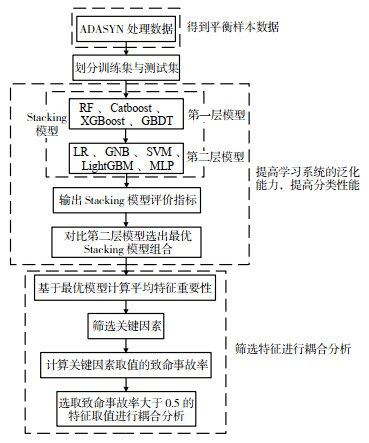
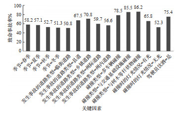
Road traffic accidents occur frequently, yet the data distribution based on traditional accident severity classification is often imbalanced. To explore the coupling effects of multidimensional factors on severe traffic accidents under sample imbalance conditions, this study proposes an analytical framework integrating the Adaptive Synthetic Sampling (ADASYN) algorithm, a Stacking ensemble learning model, and the Apriori algorithm. Utilizing data from the U.S. Department of Transportation's Fatality Analysis Reporting System (FARS) from 2017 to 2021, fifteen potential feature variables are selected across four dimensions—human, vehicle, road, and environment—to analyze the effects of multidimensional factor coupling on the occurrence of severe accidents. The ADASYN algorithm was employed to address sample imbalance. Four classical machine learning models including random forest (RF), categorical boosting (CatBoost), extreme gradient boosting (XGBoost), and gradient boosting decision tree (GBDT), are selected as base learners. Five types of meta-learners, namely logistic regression, Gaussian Na?ve Bayes, support vector machine (SVM), light gradient boosting machine (LightGBM), and multilayer perceptron (MLP), are compared to identify the optimal Stacking ensemble model with the strongest generalization performance. Based on the optimal model, feature importance ranking is obtained to determine key influencing factors, followed by the application of the Apriori algorithm for multidimensional coupling analysis, which explored the impact of five-dimensional factor coupling on the rate of severe accidents. The results indicate that: ①The Stacking ensemble model composed of Logistic Regression as the meta-learner and RF, CatBoost, XGBoost, and GBDT as base learners achieved the best overall performance, with a recall of 0.80; ②The five factors of road type, season, collision type, lighting conditions at the time of the collision, and driver alcohol consumption, accounted for 53.2% of the total importance of all factors, which is substantially higher than that of the other variables. Among them, collisions involving"impact with trees or other pole-like objects"exhibited the highest severe accident rate at 86.2%, and the severe accident rate under illuminated conditions is 13.5% higher than under non-illuminated conditions; ③ Multidimensional factor coupling analysis reveals that the probability of severe crashes is highest when multiple factors coexist: municipal roads, sober drivers, transitions between unlit and lit lighting conditions at the time of the collision, and the autumn season. Under this coupled condition, the confidence level reaches 89.0%, challenging the conventional perception that non-drinking is a low-risk factor.
A Kinematic Model and Trajectory Tracking Control of Tractor-Aircraft System Based on Front Wheel Angle Compensation
SUN Yankun, XIE Xinlong, ZHANG Wei
2025, 43(5): 79-92. doi: 10.3963/j.jssn.1674-4861.2025.05.008
Abstract(10) HTML (10) PDF(3)
Abstract:
The traditional kinematic model of the tractor-aircraft system exhibits insufficient accuracy under low-speed taxiing towing conditions, resulting in significant trajectory tracking control errors and slow responses, which is difficult to meet the stringent requirements for trajectory accuracy and safety for the new departure mode. To improve the accuracy of the kinematic model and the performance of trajectory tracking, this study proposes a kinematic model compensation method based on a front wheel steering angle compensation function of the tractor. Taking the Weihai Guangtai AM210 rodless tractor and the B737-800 aircraft as research objects, a traditional kinematic model of the tractor-aircraft system is first established. Then, the traditional kinematic model and the Trucksim vehicle model are subjected to open-loop joint simulation and comparative analysis. The trajectory deviations between these two models are compensated by introducing a compensation function. Meanwhile, a trajectory tracking controller for the tractor-aircraft system based on nonlinear model predictive control (NMPC) is designed. Taking the double-shifting line condition as the reference trajectory, a closed-loop joint simulation model utilizing MATLAB/Simulink and Trucksim is built, and the trajectory simulation comparison and analysis between the NMPC controller and the traditional proportional-integral-derivative control trajectory tracking controller are conducted to verify the superiority of the NMPC controller. The tracking performance of the NMPC controller based on the traditional and compensated kinematic models is further evaluated at tractor speeds of 2 m/s and 4 m/s respectively, and the influence of different initial deviations on the trajectory tracking performance of the tractor-aircraft system is analyzed. The simulation results show that the NMPC controller based on the compensated kinematic model can reduce the peak tracking error by 61.93% and 41.63%, and the root mean square errors by 56.14% and 37.69%, at tractor speeds of 2 m/s and 4 m/s, respectively. Under the condition of existing initial deviations, the trajectory tracking controller based on NMPC can enable the system to correct the initial deviations (lateral deviation of 0.5 to 1 m and heading angle deviation of 0.05 to 0.1 rad) within 30 s without overshoot.
A Prediction Method for Pedestrian Trajectory in Autonomous Driving Scenarios Based on LiDAR
MA Qinglu, LI Shipeng, ZHANG Jie, LIU Ming
2025, 43(5): 93-102. doi: 10.3963/j.jssn.1674-4861.2025.05.009
Abstract(10) HTML (4) PDF(0)
Abstract:
To enhance pedestrian trajectory prediction accuracy in autonomous driving scenarios, this study proposes an improved adaptive interactive multiple model unscented Kalman filter (AIMM-UKF) method based on Li-DAR point cloud processing. Raw point clouds are processed using streaming techniques involving voxel grid downsampling and ensity-based spatial clustering of applications with noise (DBSCAN) clustering to extract the centroid of the minimum bounding box of pedestrians as observation input, which can enhance data reliability and real-time performance. A three-layer adaptive mechanism is introduced into the traditional interactive multiple model unscented Kalman filter (IMM-UKF) framework: time-varying transition probabilities adjusted based on likelihood functions, a weight correction factor to reinforce superior models and suppress mismatched ones, and adaptive observation noise covariance adjusted according to point cloud density to handle sparse long-range data. Experimental validation uses a VLP-32 LiDAR in a campus test scenario for pedestrian trajectories within 5 to 20 m. It shows that the proposed method reduces overall prediction error by 23.02%, and peak error during sharp turns by 29.76% compared to conventional IMM-UKF. Errors are consistently reduced by over 21% across the tested range, with the error at 20 m decreasing from 27.15 to 21.26 cm, demonstrating long-distance adaptability. Compared to state-of-the-art generative models (HSTGA, MSWTE-GNN, MPIFN), the proposed method achieves an average displacement error (ADE) of 19.3 cm, 7.21% lower than the best-performing MPIFN, while requiring only 62 ms per frame, meeting the real-time requirements of autonomous driving systems. This method enables high-accuracy, low-latency pedestrian trajectory prediction in structured environments through the synergistic optimization of point cloud streaming and adaptive multi-model filtering.
A Coordinated and Coupled Control and Optimization Method of Intelligent Connected Vehicle Platoons and Traffic Signals Based on Hierarchical Architecture
LIU Yanbin, NING Xiaomin, YANG Aixi
2025, 43(5): 103-114. doi: 10.3963/j.jssn.1674-4861.2025.05.010
Abstract(15) HTML (5) PDF(1)
Abstract:
To address the challenge of the disconnection between vehicle platoon control and traffic signal optimization in a mixed traffic environment consisting of intelligent connected vehicles (ICV) and human-driven vehicles (HDV), this study investigates a hierarchical "vehicle-signal" cooperative control architecture. The aim is to achieve integrated and efficient allocation of road spatio-temporal resources through dynamic interaction between lower-level ICV car-following control and upper-level signal optimization. In the lower-level control, to enhance platoon stability and robustness, this study improves the classical intelligent driver model (IDM) and constructs an enhanced platoon-based intelligent driver model (PIDM). Its core innovation lies in introducing a multi-predecessor state feedback mechanism, whereby the acceleration of a following vehicle is determined not only by the state of its immediate predecessor but also incorporates the velocity and spacing information of the leader vehicle as a feedforward compensation term. This mechanism is implemented via an adjustable weighting coefficient k, effectively suppressing platoon string instability caused by wave propagation effects. Furthermore, using Lyapunov stability theory, this study rigorously proves that even if a single vehicle experiences short-term acceleration or deceleration failures causing deviation from the equilibrium state, this feedback mechanism ensures the entire platoon system asymptotically returns to a stable operating equilibrium point. In the upper-level control, a signal optimization strategy dynamically coupled with the lower-level platoon states is designed. This strategy pioneers the combination of a "dedicated ICV phase" and an adaptive green wave coordination algorithm: on one hand, it provides exclusive time windows for ICV platoons; on the other hand, based on real-time predictions of platoon average speed and arrival time output by the PIDM, it dynamically adjusts phase sequence and offset to generate a seamless "green wave" band through multiple intersections, thereby minimizing stop delays for both ICV platoons and subsequent HDVs. Simulation experiments demonstrate that the proposed PIDM control model can gradually restore an ICV platoon to its original equilibrium state after short-term acceleration or deceleration failures cause deviation from stability. When the feedback weighting coefficient k falls within the range of [0.075, 0.125], the PIDM achieves satisfactory control performance; ideal control effectiveness is obtained when the response delay time T is 0 s. As the response delay time T increases in the platoon model, the amplitude and frequency of the system control input both increase, yet the platoon system remains stable. Moreover, under an ICV penetration rate of 80%, the cooperative control scheme improves the total intersection throughput by 14.16% and the capacity of the ICV-dedicated lane by 14.78% compared to a scheme without a dedicated phase. The results verify the effectiveness of the hierarchical architecture in significantly enhancing the spatio-temporal resource utilization of ICVs while ensuring the traffic efficiency of HDVs.
Gender Differences in Drivers' Eye Movement Characteristics at High-Density Interchanges
CHEN Yongtong, YANG Zimiao, WANG Tao, ZHU Xinglin, XU Jin
2025, 43(5): 115-127. doi: 10.3963/j.jssn.1674-4861.2025.05.011
Abstract(11) HTML (3) PDF(0)
Abstract:
In order to analyze the differences in eye movement characteristics of drivers of different genders in a high-density interchange environment, a real vehicle driving test is conducted on the Donghuan-Zhangjialiang high-density interchange section in Chongqing, involving 38 subjects with one invalid data. Eye movement indicators such as fixation point position, duration, frequency, saccade amplitude, speed, and frequency are collected. Based on the trajectory characteristics of interchange driving, the driving process is divided into four conditions, including entering the main line, exiting the main line, main line driving, and auxiliary road driving. The visual drivers area of interest on the high-density interchange of expressway are divided into seven regions using the k-medoids dynamic clustering method, and a fixation transition model is constructed via the Markov chain to comparatively analyze the eye movement characteristics and fixation transition rules of drivers of different genders. The results indicate that the average value of the driver's fixation time is mainly distributed in 100~200 ms, of which the maximum value of fixation time is 299.1 ms and the minimum value is 68.0 ms. There are differences between male and female drivers in terms of fixation frequency, single fixation time, saccade amplitude and saccade frequency, the maximum fixation frequency for males is higher than that for females, reaching 2.6 n/s, while the minimum for females is lower than that for males, being 0.15 n/s. The maximum saccade frequency for females is higher than that for males, reaching 7.9 n/s, while the minimum for males is lower than that for females, being 0.8 n/s. Male drivers exhibit a lower frequency of fixation, longer duration of single fixation, and higher amplitude and speed of saccade, while the situation is converse for female drivers. Gender differences are also manifested in the behavior of fixation shift: in regular clearance interchanges, male drivers tend to focus more on the distant area of the current lane and the right rearview mirror, whereas female drivers pay greater attention to the nearby area of the current lane and the left rearview mirror. In small clearance interchanges, male drivers show higher concern for the distant area of the current lane and the left rearview mirror, while female drivers focus more on the front of the current lane and the front of the left and right lanes. In simple driving scenarios such as mainline/auxiliary roads, female drivers conduct more meticulous observations of the road environment, while male drivers are more preoccupied with information related to vehicle speed control and route planning.
Freeway Lane-Level Traffic Flow Prediction Method Based on Multi-Scale Spatial Feature Fusion
XI Kuan, ZHANG Cunbao, LI Chun, LU Yuxin, GAO Siyu
2025, 43(5): 128-136. doi: 10.3963/j.jssn.1674-4861.2025.05.012
Abstract(11) HTML (4) PDF(1)
Abstract:
Existing studies on freeway traffic flow prediction mainly focus on single cross-sections, without fully considering spatio-temporal correlations across lanes and along upstream downstream segments. The intrinsic relationship between flow and speed is also often neglected. This study proposes a lane-level freeway traffic flow prediction method based on multi-scale spatial feature fusion. The method quantifies and compensates for spatial time-lag effects between adjacent sections, reducing temporal misalignment of upstream and downstream flow sequences. For spatial feature extraction, flow and speed data with time-lag effects removed are integrated and processed through three-scale dual-channel 3D convolutional modules with attention mechanisms. These modules dynamically capture local inter-lane interactions, global propagation patterns between sections, and intrinsic flow-speed dependencies. For temporal modeling, a long short-term memory network is employed to extract global temporal dependencies among multi-scale spatial features, and a fully connected layer generates final predictions. Empirical validation using real PeMS freeway data demonstrates that, in one-step prediction tasks, the proposed method reduces the mean absolute error, root mean square error, and mean absolute percentage error by at least 6.61%, 5.50%, and 8.46% on average compared with the other models. In multi-step prediction, average errors across horizons decrease by up to 14.09%, 15.25%, and 29.16%, confirming the method's effectiveness in capturing fine-grained multi-scale spatio-temporal features and its significant advantage in prediction accuracy. Furthermore, ablation experiments verify that the attention mechanism and the collaborative integration of multi-scale spatio information play crucial roles in improving freeway traffic flow prediction performance.
An Ecological Assessment Method for Lane-Changing Overtaking Behavior Based on FL-XGBoost
YAN Lixin, DENG Guangyang, CHEN Qingyun, GAO Yating
2025, 43(5): 137-146. doi: 10.3963/j.jssn.1674-4861.2025.05.013
Abstract(11) HTML (6) PDF(1)
Abstract:
Lane-changing overtaking is a continuous and complex process that has a significant impact on energy consumption. Traditional eco-driving research primarily focuses on common factors, such as overall acceleration frequency, while overlooking the heterogeneous effects on driving behaviors across different periods of driving process. This study develops an improved extreme gradient boosting model based on the local loss function (FL-XGBoost model) to account for temporal heterogeneity and analyze the stage-dependent impacts of driving behaviors on energy consumption. Considering the dynamic characteristics of lane-changing overtaking, the entire process is divided into four phases, and corresponding stage-specific driving behavior datasets are constructed. To achieve dimensionality reduction and extract key information from the feature space, a hybrid feature selection strategy integrating random forest (RF) and ant colony optimization (ACO) is adopted. Furthermore, aiming at the model bias caused by class imbalance in the dataset, the focal loss function is introduced as the optimization objective in place of the traditional cross-entropy loss, thereby enhancing the robustness and generalization performance of the model. Results show that the proposed FL-XGBoost model outperforms other baseline models such as support vector machine (SVM). Compared with the unmodified XGBoost model, the FL-XGBoost model achieves improvement of 3% in accuracy and 5.1% in the F1-score. To further reveal the causal relationships between influencing factors and energy consumption, SHAP (Shapley Additive Explanations) is adopted for model interpretability analysis. The results indicate that the proportion of acceleration duration during the two lateral lane-changing phases exerts the most significant impact on the eco-driving performance of the entire lane-changing overtaking process. Nonlinear coupling effects exist among eco-driving features across multiple phases of the process.
Route Planning for Electric Vehicle Delivery Considering Charging Queuing Delay
MENG Yun, ZHANG Zhiwen, DAI Liang, GOU Xin, LIU Sainan
2025, 43(5): 147-158. doi: 10.3963/j.jssn.1674-4861.2025.05.014
Abstract(7) HTML (3) PDF(2)
Abstract:
The load and transmission in electric vehicle delivery make the power consumption nonlinear. Meanwhile, charging and queuing delays will affect the efficiency of delivery. To address this issue, a delivery route planning method for optimizing the selection of charging stations and charging time by applying a dynamic energy consumption model is studied. By adopting the electric vehicle dynamic energy consumption rate (ECR) model, a nonlinear energy consumption function relationship related to the load is established. Meanwhile, for the charging process of electric vehicles in queues, based on the queuing theory model, the functional relationships between the arrival rate of electric vehicles, service rate, charging station capacity and charging queuing delay (CQD) are analyzed. Then, based on the above analysis of ECR energy consumption and CQD latency, a route planning model aiming to minimize the total travel time is established. The model considers the access constraints, electric vehicle load constraints, and battery charge constraints to ensure its feasibility and accuracy in scenarios involving multiple vehicles, multiple tasks, and multiple charging stations. To efficiently solve the model, an optimization algorithm based on deep reinforcement learning (DRL) is designed. Specifically, for the problem of queueing and charging timing decisions, a dynamic decision-making algorithm using real-time information from charging stations is developed to reduce the difficulty of learning process of the DRL and improve the computational efficiency. Finally, the effectiveness of the proposed method is verified through multi-scale simulation experiments. The experimental results show that this method effectively optimizes the charging queuing time, reducing the average total driving time per vehicle by 0.14 hours; compared with various typical intelligent optimization algorithms, the comparison results show that the proposed method achieves an average reduction of 0.52 hours in travel time per vehicle and improves computational efficiency by 75.4%.
An Analysis of Driving Maneuver Behavior on Urban Underground Helical Ramps Based on Acceleration Data
ZHENG Zhanji, ZHENG Liwei, RAO Jiaqiang, XU Yuxuan, TU Qiang
2025, 43(5): 159-168. doi: 10.3963/j.jssn.1674-4861.2025.05.015
Abstract(12) HTML (7) PDF(1)
Abstract:
Urban underground spiral ramps, with complex alignment and confined environments, often cause driver stress and spatiotemporal disorientation. To examine and quantify driver behavior on these ramps, 21 participants completed real-vehicle driving tests on the Hongyamen Underground Road and the Jiefangbei Underground Ring Road in Yuzhong District, Chongqing. The longitudinal and lateral acceleration data under natural driving conditions are collected using a micro-mechanical attitude and heading reference system. The probability distribution characteristics of longitudinal acceleration and lateral comfort of vehicles on the helical ramps are analyzed. The multivariate analysis of variance method is used to evaluate the changes in vehicle acceleration across different curve radii and slope ranges. Then, the relationship measurement model of curve radius, longitudinal slope and longitudinal/lateral acceleration is constructed. The results show that: ①The measured acceleration and deceleration data of the helical ramp exhibit positive skewness. The upward ramp curve has a broader acceleration range than deceleration, indicating that drivers tend to accelerate more in this section. Conversely, in the downward ramp curve and straight section, deceleration prevails. The deceleration preference value in the straight section exceeds the acceleration preference value. Moreover, both acceleration and deceleration preference values in standard-radius curves are higher than those in small-radius curves. ② The longitudinal acceleration variation characteristics of the helical ramp curve are primarily manifested in three stages: the decrease stage at the curve, a middle stage with fluctuations or stabilization, and the increase stage at the curve. The longitudinal acceleration in the upward direction gradually increases before becoming gentle, while in the downward direction, it initially decreases and then stabilizes. ③The difference between the characteristic quantile values of the lateral acceleration's mean and peak value of each curve on the helical ramps is above 1 m/s2. Driving comfort is lower on left-turning curves than on right-turning curves, and comfort on standard-radius curves is higher than on small-radius curves. ④Longitudinal acceleration, braking deceleration, and lateral acceleration are not significantly affected by the radius of the bend and the slope of the longitudinal slope (p >0.05) but are significantly affected by their coupling effect (p < 0.001).
A Travel Time Prediction Model for Rescue Vehicles Based on Tensor Decomposition
LU Shuibo, LIU Zhizhen, TANG Feng, HAO Wei, LI Shuxin, ZHANG Zhaolei
2025, 43(5): 169-179. doi: 10.3963/j.jssn.1674-4861.2025.05.016
Abstract(12) HTML (6) PDF(1)
Abstract:
Rescue vehicles have the right of way when driving on urban roads, and predicting their travel time in the urban road network can provide support for rescue activities according to the driving characteristics of rescue vehicles, which can effectively improve rescue efficiency. This paper proposes a model for predicting the travel time of rescue vehicles based on tensor decomposition considering congestion, termed the rescue vehicles travel time prediction model based on tensor decomposition (RTPT). The RTPT model integrates tensor decomposition algorithm, travel characteristics extraction, and a travel time prediction algorithm, all considering road congestion states. The tensor decomposition algorithm fused with congestion state constructs an urban road travel time tensor based on vehicle trajectory data, applying congestion-informed Tucker tensor decomposition to complete missing data. The travel characteristics extraction method examines the distinct driving patterns of rescue vehicles in contrast to social vehicles, constructing a travel time tensor for rescue vehicles in the urban road network. In the travel time prediction algorithm, a congestion probability tensor is constructed to weight the road congestion probabilities for predicting rescue vehicles travel time across varying data sparsity and time intervals. Experimental results show that RTPT achieves a substantial reduction in average absolute error, outperforming traditional methods: driver-based road trip time estimation (DRTE), moving average (MA), and historical average (HA) by 32.44%, 70.66% and 74.50%, respectively. Additionally, the model reduces the root mean square error by 24.28%, 69.73% and 74.67%, compared to DRTE, MA, and HA, respectively, exhibiting minimal error across all prediction scenarios and data conditions. With the increase of data sparsity and prediction period, the variation of the prediction error range of RTPT is basically kept within 1 s, showing its good stability and robustness. The integration of the congestion probability tensor significantly enhances the model ability to reflect the unique driving characteristics of rescue vehicles while incorporating comprehensive traffic network information, resulting in improved prediction accuracy.
A Multi-UAV Path Planning Algorithm Based on DMPC-A* Fusion
ZHAO Liqiang, LIU Yuxin, WANG Ershen, XU Baosheng, JI Guipeng
2025, 43(5): 180-190. doi: 10.3963/j.jssn.1674-4861.2025.05.017
Abstract(12) HTML (5) PDF(1)
Abstract:
Aiming at the problems of low efficiency and poor flight stability faced by path planning for multi-UAV cooperative target tracking and dynamic obstacle avoidance in complex three-dimensional airspace environments, A path optimization method based on the integration of distributed model predictive control (DMPC) and A* search algorithm was studied. The A* algorithm is utilized to generate the global initial paths of multiple unmanned aerial vehicles (UAVs), assign reasonable target trajectory points to each UAV, and provide basically feasible safe trajectories for the UAVs. The Bezier curve is integrated with the DMPC prediction model. By optimizing the parameters of the curve control points, the smoothness of the path and the continuity of the track are improved. Considering the dynamic constraints of the unmanned aerial vehicle, the track length constraints, the safety distance constraints and the communication condition constraints comprehensively, a multi-objective cost function is constructed and solved by rolling optimization to achieve real-time dynamic adjustment of the track. To balance multiple costs such as flight range, threat, energy consumption and control input, the cost weight coefficients are recalibrated to ensure the safety and global optimality of group flight. Meanwhile, in view of the problems of large computational load and poor real-time performance of the traditional centralized model predictive control (MPC), a distributed solution strategy is adopted, enabling each unmanned aerial vehicle to independently optimize the control input and achieve collaborative target tracking through information interaction, thereby significantly reducing the computational complexity of the algorithm. The experimental simulation environment adopts a three-dimensional space of 5.2 m×5.2 m×3.0 m, deploys 10 unmanned aerial vehicles and static obstacles with different shapes, and verifies the effectiveness of the method through multiple Python program simulation experiments. The results show that: Compared with the traditional algorithm, the DMPC-A* fusion method proposed in this paper can shorten the path length by approximately 4.2%. Besides, the track smoothness and stability are also improved. The algorithm proposed in this paper has good obstacle avoidance ability and environmental adaptability, providing technical support for the research on collaborative path planning for multiple unmanned aerial vehicles.