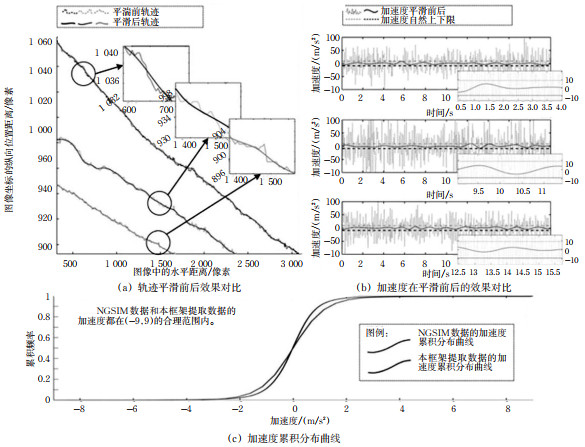
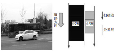
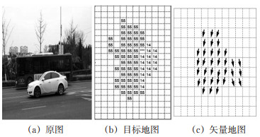
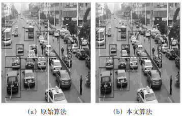
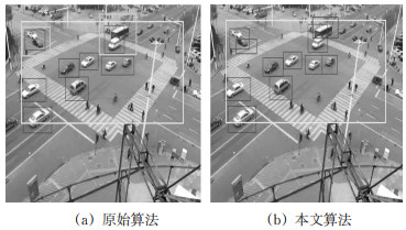
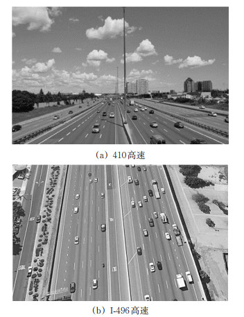
2021 Vol. 39, No. 2

2021, 39(2) doi: 10.3963/j.issn.1674-4861.2021.02.020
Abstract(123) PDF(0)
Abstract:
Overview
A Review on Optimization of Unmanned Ship Path Based on Collision Avoidance Rules
XU Xiaofeng, XIAO Yingjie, ZHANG Xuelai
2021, 39(2): 1-8. doi: 10.3963/j.jssn.1674-4861.2021.02.001
Abstract(502) HTML (229) PDF(53)
Abstract:
In the era of artificial intelligence and big data, autonomous ships have attracted extensive attention from scholars at home and abroad due to their safety and efficiency. However, the development of relevant laws and regulations and collision avoidance path planning is imbalanced. The concept of traditional path optimization and algorithm has certain deviation, which is limited to global or local planning not guaranteeing the safety of a ship running. Based on the collision avoidance rules, the paper sorts out the relevant specifications of autonomous piloted ships and analyzes the latest research results of path optimization of autonomous piloted ships. Also, the current model of path planning of autonomous piloted ships is elaborated, including intelligent algorithms, planning objectives, and constraints. Given the existing problems of collision avoidance of autonomous piloted ships, the legal and regulatory system of autonomous piloted ships should be improved from the aspects of definition, supervision, and division of responsibilities. The further development trend of autonomous piloted ships is predicted by improving the traditional collision avoidance path planning algorithm easy to fall into the defects of the local optimal solution and slow solving process.
A Review on Cognition and Evaluation of Traffic Signs on Expressways
WANG Renjie, ZHOU Xiaohong
2021, 39(2): 9-18. doi: 10.3963/j.jssn.1674-4861.2021.02.002
Abstract(550) HTML (174) PDF(42)
Abstract:
Traffic signs, as the link of information exchange between highways and drivers, are an essential part of road traffic. At present, some achievements have been made in studying traffic signs, but there are still some shortcomings in some aspects. Therefore, this paper summarizes influencing factors of recognizing traffic signs. The analysis is performed from legibility, recognition rate, the understanding ability of drivers, and driver's driving level. The effectiveness evaluation is divided into quantitative analysis and qualitative and quantitative analysis. The results show that there are big differences between the expressways and urban roads, which should be considered to study the influencing factors of recognizing traffic signs. Since the amount of information contained in each sign varies, the information theory should be introduced to obtain an accurate threshold of information. In the future, the cross integration of different disciplines should be strengthened. The statistical probability model is combined with a cognitive model to establish a new cognitive model. The compensation strategy of driving and the range of sympathetic arousal will be the key directions. Traffic signs mostly appear in the form of combinations, so traffic sign groups should be studied in the future.
Transportation Safety
Steering Collision Avoidance Control of Intelligent Vehicles for Crossing Pedestrians at Unsignalized Intersections
PAN Mingming, SUN Yubo, LIU Qiang
2021, 39(2): 19-27. doi: 10.3963/j.jssn.1674-4861.2021.02.003
Abstract(373) HTML (192) PDF(34)
Abstract:
An active steering collision avoidance control strategy is proposed to cope with pedestrian-vehicle collision avoidance of intelligent vehicles at unsignalized intersections. Based on the multi-layer model predictive control method, the local planning layer controller and the global tracking layer controller are designed by the hierarchical control strategy. On this basis, the remaining time of pedestrian-vehicle collision is calculated according to the trajectory characteristics of vehicles and pedestrians at intersections, and the modified traditional artificial potential field method is employed to construct the collision avoidance function. The local collision avoidance path is planned to minimize the deviation of tracking the global reference path and avoid any pedestrian-vehicle collision at intersections. By CarSim/Simulink co-simulation platform, various scenarios are designed for simulation analysis. The factors that have significant effects on pedestrian-vehicle collision at intersections are selected from the traffic accident database of Guangdong Province from 2006 to 2018. The results show that intelligent vehicles can track the reference path at different initial points, and the controllers have good robustness subjected to different speeds and adhesions. In a high-speed and low-adhesion scenario, the lateral acceleration of intelligent vehicles is less than 0.4 g; the side-slip angle is less than 2°; the front wheel yaw angle is less than 2.5°. At the four typical unsignalized intersections, intelligent vehicles at different speeds can steer to avoid collision for crossing pedestrians when going straight or turning through the intersection.
Design Indices of Circular Curve Section Based on Lateral Stability
ZHANG Hang, CHU Zeyu, LYU Nengchao, DUAN Hezhu
2021, 39(2): 28-35. doi: 10.3963/j.jssn.1674-4861.2021.02.004
Abstract(248) HTML (127) PDF(13)
Abstract:
When a vehicle turns in a circular curve section with a small adhesion coefficient, its tires work in a nonlinear zone, and the lateral stability analysis method based on the linear theory would generate large errors. This paper focuses on the different characteristics of the 6-DOF nonlinear vehicle system model in nonlinear and linear domains. Under different speed and road adhesion coefficients, the radius and superelevation design indices of the circular curve section with the critical state of the vehicle system are calculated. The root locus method based on the linear theory and the phase plane method based on the nonlinear theory are used to analyze the lateral stability of vehicle systems in linear and nonlinear domains, respectively. Then, a sectional index of the circular curve considering the critical instability state of vehicles in both states is obtained. The results show that when the vehicle speed is 60 km/h, with the road adhesion coefficient of 0.24, and the superelevation less than 6%. The tires are in the nonlinear domain when the vehicle lateral instability occurs. Besides, a critical index of lateral instability is obtained using the phase plane method. When the vehicle speed is 60 km/h, the road adhesion coefficient is greater than 0.4, and the superelevation is between 4 and 10%. The tires are in the linear domain when the vehicle lateral instability occurs, and the root system is used. Then a critical index of lateral instability is obtained by trajectory analysis.
Correction Computation of Stopping Sight Distance in Approaching Section of Mountain Tunnel Based on Traffic Flow Theory
LIANG Bo, LI Shuo, ZHONG Shengming, PU Junyong
2021, 39(2): 36-42, 52. doi: 10.3963/j.jssn.1674-4861.2021.02.005
Abstract(281) HTML (157) PDF(15)
Abstract:
Speed is the most important calculation parameter in stopping sight distance. However, the existing correction computation of the model of stopping sight distance does not consider the impacts of traffic environment in mountain tunnel on the driving speed. Four representative mountain tunnels in Chongqing are selected to carry out field experiments, thus studying characteristics of speed flow in the approaching section of mountain tunnel. The data of speed and traffic flow in the approach section is used to analyze the distribution law and statistical relationship of traffic flow and speed. Then a model of the relationship between vehicle speed and traffic flow in the approaching section is developed to derive the stopping sight distance formula based on the characteristics of speed flow. The values of relevant standards and norms are compared to reveal the law of change. The results show that the speed of the approaching section of the mountain tunnel decreases first and then increases. Traffic flow is significantly related to vehicle speed. After fitting, a calculation model with coefficient R2 =0.9 is obtained. At the same speed, the modified value is about 1.07 to 1.21 times of the standard value. The greater the speed, the greater the differences. The modified stoppingsight distance length can meet the needs of 70% drivers at least. Based on the corresponding regulations, the impacts of traffic flow on vehicle speed of the stopping sight distance is considered to improve the driving safety level in the approaching section of the mountain tunnel.
A Stopping Sight Distance in Access Zone of Highway Tunnel Based on the Reaction Time
LIANG Bo, XIAO Yao, PU Junyong
2021, 39(2): 43-52. doi: 10.3963/j.jssn.1674-4861.2021.02.006
Abstract(346) HTML (192) PDF(21)
Abstract:
The reaction time is an important factor of stopping sight distance. The existing models of stopping sight distance seldom consider the influences of the environment outside the highway tunnel on reaction time of drivers. Twenty-five drivers are selected to carry out indoor simulation tests under different distances from the tunnel entrance, test time points, and vegetation area outside the tunnel to study the distribution of reaction time in the access zone of the highway tunnel. The platform for measurement of reaction time in the road tunnel is used to collect the reaction time of drivers, and ANOVA is used to test the significant differences in the data. A model of the relationship among the reaction time, distance, and time points is developed to quantify the impacts of distance and time on the reaction time. The results show that: ① The reaction time corresponding to different test points(distances from the entrance)has an overall significant difference. The reaction time first decreases and then increases with the decreased distance from the entrance, and reaches the minimum between 40 and 60 m from the entrance. ② The reaction timecorresponding to different vegetation area percentages has no overall significant difference. ③ The reaction time corresponding to different test time points has an overall significant difference, and there is no interaction between the test time point and the test point. The reaction time first decreases and then increases with the increase of time point, and reaches the minimum at 4 pm. ④ The correction coefficient of the new stopping sight distance model based on the reaction time is 0.62, with its calculated value less than the standard calculated value. The difference between the two increases with the increase of the design speed. ⑤ After verifying the measured value of the new tunnel, there is no significant difference between predicted and measured values, indicating that the model has a good predictive ability.
A Method to Identify Traffic Incidents Based on Social Network Data
LIU Zhao, HE Shanglu, LIU Yingshun
2021, 39(2): 53-60. doi: 10.3963/j.jssn.1674-4861.2021.02.007
Abstract(464) HTML (187) PDF(32)
Abstract:
A text classification method based on machine learning is studied to identify traffic incidents by mining the data from the social networks. The original texts are crawled by web crawler"Beautiful Soup"based on the keywords and location. These texts are preprocessed using regular expression matching, duplicate removing, and"0-1"mark? ing. According to the features of preprocessed texts, the paper proposes a method to select feature words based on fea? ture weights. The feature weight is calculated by normalizing, weighting, and combining the word frequency and the ratio of the text containing that word. Accordingly, the feature weight of each unique word in the training set of the traf? fic incident text can be achieved, used as a criterion for selecting feature words, and as the inputs of classifiers. A test is conducted to compare different classifiers and methods to select feature words. The results show that the proposed method to select feature words combined with the XGBoost classifier has the optimal performance, with a precision rate of 0.679 6, a recall rate of 0.648 1, an F1 value of 0.663 5, and an AUC value of 0.759 4.
Transportation Information Engineering and Control
Association of Vehicle Object Detection and the Time-space Trajectory Matching from Aerial Videos
FENG Ruyi, LI Zhibin, WU Qifan, FAN Changyan
2021, 39(2): 61-69, 77. doi: 10.3963/j.jssn.1674-4861.2021.02.008
Abstract(391) HTML (306) PDF(60)
Abstract:
High resolution track data contains rich information about vehicle travel and traffic flow. The fusion method of cross-frame vehicle detection association and trajectory matching is developed to extract the vehicle trajectories from the aerial video. The convolutional neural network, YOLOv5, is used to obtain video-wide vehicle object detection. Base on the result of detection, a correlation algorithm of a cross-frame target under the constraints of vehicle dynamics and trajectory confidence is proposed. Then, broken track matching and constructing algorithms based on the maximum correlation are established for identifying unique vehicles. The trajectory is converted from image coordinates to Freenet coordinates under lane reference, and the ensemble empirical mode decomposition(EEMD)model has been constructed to eliminate data noise. Two sets of open-source aerial videos, coving congestion and free-flow traffic status, are taken by a drone on the Nanjing expressway to test the effect of the trajectory extraction algorithm. The results show that the trajectory accuracies are 98.86 and 98.83% under the free flow and congested conditions, respectively. Besides, the track recall rates are 93.00 and 86.69%. The trajectory extraction speed of the algorithm is 0.07 s/vehicle/m. The vehicle trajectory dataset processed by this method can provide extensive data support for traffic flow, traffic safety, and traffic control research. The dataset is published at http://seutraffic.com/.
Drivers' Travel Pattern Mining Based on OBD Data
MA Xiaolei, YAO Liliang, SHEN Xuanliangan
2021, 39(2): 70-77. doi: 10.3963/j.jssn.1674-4861.2021.02.009
Abstract(235) HTML (123) PDF(13)
Abstract:
The traditional travel pattern research mainly relies on questionnaires to analyze the driver's travel characteristics, the result of which is not objective. In order to solve the problem, the study analyzed and identifieddifferentdrivers' travel patterns based on the vehicle on-board diagnosticdata from 3 570 private cars in Beijing within two months. According to the parameters recorded from vehicles, a clustering algorithm called Clustering by Fast Search and Find of Density Peaks was used to classify different drivers into high-frequency travelers, commuting travelers, long-distance and occasional travelers and dangerous travelers, and analyzed from the aspects of average travel distance, travel frequency, travel time and dangerous driving behavior times of 100 km, to reflect the variability and regularity of driver's travel pattern. According to the clustering result, the multi-dimensional discrete Hidden Markov Model was used for modeling and measurement. Results indicate that the algorithm proposed shows good accuracy on the identification of drivers' travel patterns. For different kinds of drivers, the averagecorrect recognition rate exceed 91% while the highest recognition rete can reach 94.5%.
A Speed Guidance Method at Signalized Intersections Based on Vehicle Infrastructure Cooperation
XU Liping, DENG Mingjun
2021, 39(2): 78-86. doi: 10.3963/j.jssn.1674-4861.2021.02.010
Abstract(483) HTML (148) PDF(61)
Abstract:
The existing speed guidance models for vehicles are not comprehensively considering the car-following behaviors and the roughdivision of guidance scenes. This paper studies four speed guidance models based on real-time optimization of eachvehicle in vehicle infrastructure cooperation. The vehicles are divided into queues, and the FVD car-following model is improved considering the influences of speed guidance. The vehicle platoon is used as the guidance unit, and the traffic conditions are subdivided into eight guidance scenarios. Withthe goals of optimizing the operating efficiency of the intersection without stopping or withless stopping, four vehicle speed guidance models are established to optimize vehicle acceleration/deceleration by calculating the target acceleration/deceleration based on the improved car-following model, that the following vehicles can cross the intersection stop line in a platoon at the same target speed withthe leading vehicle. The intersection between Haitang NorthRoad and Fenglin West Street in Nanchang is taken as a case study for verification. The results show that the proposed model can reduce vehicle travel time by 18.9%, maximum queue lengthby 58.8%, delay by 60.8%, and fuel consumption by 36.4%. It is suitable for different traffic saturation conditions, significantly improving the traffic at signalized intersections and reducing vehicle fuel consumption.
A Green Wave Optimization Control Model of Trunk Buses Considering Green Extension
QIANG Tiangang, LIU Tao, PEI Yulong, YANG Shijun
2021, 39(2): 87-94. doi: 10.3963/j.jssn.1674-4861.2021.02.011
Abstract(352) HTML (97) PDF(22)
Abstract:
Since the actual travel time of buses at intersections is longer than that of social vehicles due to the green light extension control strategy, this paper proposes an optimization control model of trunk line signal coordination considering a green extension. The starting point of the green light is selected as the basis for calculating the absolute phase difference, considering the bus running speed and stop time in the MAXBAND model. The maximum green extension time is combined to improve the constraints on the green wave bandwidth and the time-distance geometric relation of the bus. Matlab is used to solve the relevant parameters of the improved model. The average queue length, the average delay of social vehicles, the average delay of buses, the average number of stops, and the average delay per person are selected as the evaluation indices of the model, and a simulation is conducted with Vissim software. The results show that when there is no bus lane, and the influences of vehicles queuing is not taken into account, the five evaluation indices of the improved model are improved by at least 2.87% compared with the model based on MAXBAND considering the bus traveling speed and stop time. Compared with the MAXBAND model, the average delay of buses increased by 1.87% in the improved model because the queuing situation of vehicles at intersections is not taken into account; however, the other four indices all increase by 1.71% at least.
A Vehicle Detecting Method Based on Pattern Recognition Combined with ST-MRF
ZHOU Jun, BAO Xu, GAO Yan, LI Yun, JIANG Qing
2021, 39(2): 95-100, 108. doi: 10.3963/j.jssn.1674-4861.2021.02.012
Abstract(199) HTML (136) PDF(13)
Abstract:
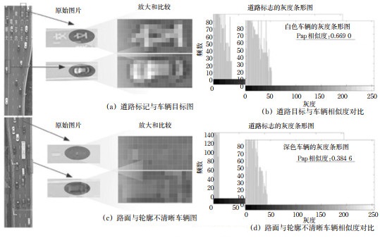
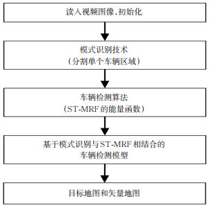
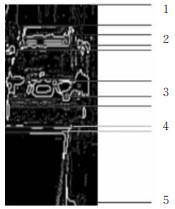
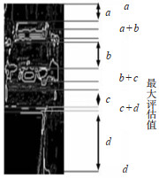
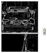
The main difficulty of the vehicle detecting technology lies in overcoming the inaccuracy of detecting, which is directly affected by video shaking, mutual occlusion between vehicles, occlusion between the vehicles, and its shadow due to illumination changes. Based on the traditional spatial-temporal Markov random field (ST-MRF), the vehicle detecting method combined with pattern recognition and ST-MRF is proposed to address the problem. The boundary between two vehicles occluding each other is segmented by the pattern recognition technology, with the edge clearances and boundary information of occluded vehicles identified. Then, the results of pattern recognition are fed back to ST-MRF algorithm, which reassigns labels to occluded vehicles, integrates incomplete segmentation, and determines individual vehicle information. The results in the road section show 325 vehicles driving in the test area, vehicles tracked by the original ST-MRF algorithm, and the success rate is 79%. When the pattern recognition technology combined with ST-MRF algorithm to calculate 315 vehicles, the success rate is 97%. The results at the intersection show that the method can obtain more accurate results of vehicle detection at the intersection where motor vehicles and non-motor vehicles are mixed, and buses and cars are obstructed by each other.
A Fusion Algorithm Based on Spatiotemporal Characteristics of the GPS Data and IC Card Data in Urban Public Transportation
ZUO Jingli, WANG Qiuping, CHEN Ju
2021, 39(2): 101-108. doi: 10.3963/j.jssn.1674-4861.2021.02.013
Abstract(221) HTML (111) PDF(20)
Abstract:
Since there is no direct connection between the GPS data and IC card data of some urban buses, it is difficult to correlate and obtain the passenger boarding data. The situation becomes more difficult when the two sets of data have irregular time deviations. The paper analyzes the fast matching data fusion of spatiotemporal characteristics, containing the following steps. Firstly, the bus timetable is obtained according to the bus GPS data and stop location matching. Then, the time similarity curve is drawn between the timetable and time-corrected IC card data through tra versal calculation. The corresponding relationship is found and verified by the curve of time-average deviation. Finally, the time correction value between the two systems is determined. The relevant three-day data is calculated on 195 buses in 5 routes in Xi'an city, where 191 vehicles have obvious identification characteristics. Besides, the algorithm is verified through 344 vehicles with known correspondences in 16 routes in Nanning City. The exact correspondence between 336 vehicles is obtained, with an average time corrected error of 16.5 s. The results show that the matching rate of the algorithm is 97.67%. For the widely existing bus GPS data and IC data belonging to different systems, it is difficult to judge the situation of bus stops by swiping the card. The proposed method expands the application scope of the original imperfect bus data and lays a foundation for analyzing individual micro travel behaviors in public transportation.
A Simulation Optimization Algorithm for Multi-aircraft Rerouting in Severe Weather
ZHU Chengyuan, YAN Nanxin
2021, 39(2): 109-117. doi: 10.3963/j.jssn.1674-4861.2021.02.014
Abstract(291) HTML (121) PDF(11)
Abstract:
A simulation optimization algorithm for multiple aircraft diversion routes under severe weather is studied to address the lack of consideration for reducing the total controller workload in the planning of multiple aircraft re-routes in the regional control area(RCA)during severe weather. Guiyang RCA is taken as a case study. A gray model is used to predict the dynamic impact range of the flight forbidden area(FFA), and a geometric algorithm is used to plan the alternative diversion routes, with the operation rules of the discrete particle swarm optimization algorithm (DPSO)improved. The simulation optimization algorithm of multiple aircraft diversion routes in severe weather is implemented by combining the predicted FFA, the pre-planned diversion routes, the improved DPSO algorithm, and the total airspace and airport modeler(TAAM)to minimize the total diversion routes and the total controller workload in the whole area. The results show that the simulation optimization algorithm, after several iterations, can obtain a diverting optimization scheme. The total controller workload decreases by 7.52%, and the total distance of diverting routes decreases by 4.48%, compared with the simulation optimization algorithm using the traditional particle swarm optimization algorithm(PSO). It has a slightly longer distance of diverting routes compared with the rerouting path algorithm using the multi-objective particle swarm algorithm(MOPSO)and the non-dominated sorted genetic algorithm-II(NSGA-II). However, the influences of controller workload should be considered. The simulation optimization algorithm can reduce the effective controller workload and the distance of diverting routes, which is useful for the planning of actually diverting routes.
Transportation Planning and Management
A Shock Effect of Ride-hailing Services on Using Traditional Taxis in Urban Areas
ZHONG Jun, LIN Yan, WU Xia, ZHAO Xuteng
2021, 39(2): 118-125. doi: 10.3963/j.jssn.1674-4861.2021.02.015
Abstract(204) HTML (65) PDF(16)
Abstract:
The rapid development of ride-hailing services significantly affects urban travel modes, including traditional taxis. An important issue is how it affects the use of traditional taxis. The balanced panel data of 33 cities in China from 2010 to 2016 are collected and quantified by difference-in-differences(DID)method. This paper also performs dynamic effect analysis, robustness test, and analysis on the city scale and urban location heterogeneities. The results show that ride-hailing services reduce the use of traditional taxis by an average of 25.46%. The negative impact of ride-hailing services initially strengthens and then weakens over time. Analysis of the city scale heterogeneity shows that ride-hailing services reduce the use of traditional taxis by 28.68% in megacities and 22.12% in the metropolis. Analysis of the city location heterogeneity of shows that ride-hailing services reduce the use of traditional taxis by 27.96% in eastern cities and 21.2% in western cities.
Traffic Flow Characteristics and Traffic Organization Strategy in a Diversion and Interleaving Area of Multi-lane Freeways
JI Tuo, ZHOU Ying, LYU Nengchao
2021, 39(2): 126-136, 152. doi: 10.3963/j.jssn.1674-4861.2021.02.016
Abstract(371) HTML (343) PDF(43)
Abstract:
Many safety problems exist in the interleaving area of multi-lane expressways due to increased lanes and traffic flow and the unreasonable setting of signs. The traffic organization form with its advantages and disadvantages of the interleaving area of multi-lane expressways is proposed by analyzing the problems in the interleaving area of multi-lane expressways and the forms of existing multi-lane expressways(integrated section, passenger-and-cargo separated sections, and main and auxiliary separated sections). According to the operating speed, capacity, safety characteristics, and conflict characteristics of the multi-lane expressway diversion and weaving area, optimized suggestions on traffic management(lane and speed managements)and guidance facilities(same direction separation zone and marking)at the diverging and weaving areas of multi-lane expressways are put forward. The proposed optimization opinions on traffic management and guidance facilities can significantly improve the safety of the interleaving area of multi-lane expressways as well as its operation.
A Method of Traffic Flow Prediction for Road Segments without Detectors Based on Spatial Structure of Local Network
YE Xiuxiu, MA Xiaofeng, ZHONG Ming, HUANG Chuanming
2021, 39(2): 137-144. doi: 10.3963/j.jssn.1674-4861.2021.02.017
Abstract(313) HTML (159) PDF(14)
Abstract:
Most links in an urban road network are not monitored by any traffic detector. Lack of traffic flow data has seriously hindered the performance of traffic management programs. In this regard, this paper proposes a traffic flow prediction method for road segments without a detector(RSWD)based on the spatial structure of the local road network. The correlation between the spatial structure of the local network and the traffic flow of the links is analyzed based on the big data of traffic flow. According to the topology of the local road network, multiple linear regression is used to estimate traffic flow assignment weights using data from links with detectors, and to analyze the impacts of the spatial structure of the local road network on traffic flow assignment weights. Then, a method for estimating the traffic flow of road segments without any detector is proposed by considering the spatial structure of the local network and traffic flow of adjacent links. The results show that a significant correlation is found among links of traffic flow and its functional class, and the number and functional class of its adjacent links. The average error of traffic flow prediction based on the proposed model is about 8% and 22% for the RSWD connected with one and several adjacent upstream links in the local road network, respectively.
An Optimization Model of Dynamic Allocation of Empty Railway Cars Based on Time-space Network
ZHENG Kexin, SONG Rui, LI Guangye
2021, 39(2): 145-152. doi: 10.3963/j.jssn.1674-4861.2021.02.018
Abstract(304) HTML (310) PDF(31)
Abstract:
The paper studies the dynamic optimization of the empty car distribution within the railway administration (or company)to reasonably allocate empty cars. The time-space network with different periods is constructed to describe the changes in work capacities of railway stations. By referring to transportation problems, dynamic empty-car distribution is transformed into the multi-commodity network flow based on the time-space network by increasing the supply and demand constraints. Combining the characteristics of empty car distribution, the paper develops two sets of integer decision variables and considers discharging and assigning empty cars separately. 0-1 auxiliary variables are set to construct substitution constraints of car types. On this basis, a mixed-integer programming model for the dynamic optimization of empty-car distribution is constructed to minimize the total cost. The feasibility and effectiveness of the model are verified by taking empty-car distribution in Kunming railway administration as a case study. The results show that dynamic empty-car distribution is superior to static empty-car distribution in reducing the total cost and fitting the actual process. The complexity of solving the model is reduced by improving the time-space network compared with the existing methods of dynamic empty-car distribution. The model can obtain the scheme of empty-car distribution and check the operation status of empty cars at different times intuitively.
Influencing Factors of Airport Terminal Wayfinding Based on an Integrated Model
REN Xinhui, HOU Huiting
2021, 39(2): 153-160. doi: 10.3963/j.jssn.1674-4861.2021.02.019
Abstract(245) HTML (164) PDF(17)
Abstract:
This paper aims to solve the problems of quantitatively measuring the influences of passengers' perception on wayfinding of airport terminals. Three latent variables, including personal quality and ability, effectiveness of perception information, and dispersion degree of perceived facilities, are proposed as variables of passengers' perception during wayfinding. An SEM-Logit integrated model of airport terminal wayfinding with passengers' perception is constructed by combining individual attributes, travel characteristics, and airport conditions. The empirical analysis is conducted using the data collected from a questionnaire survey. The results show that the latent variables of perception factors significantly affect the wayfinding process in the terminal. Personal qualities(0.107)and effectiveness of perceived information(0.379)have positive impacts on the convenience of wayfinding, while degree of dispersion of perceived facilities(-0.330)has negative impacts. The age and gender of passengers are also key factors affecting the wayfinding in the terminal. The results show that the integrated model considers factors more comprehensively and has a stronger explanatory ability than the basic regression model.