



AIS-Information-Aided Ship Association and Identification in SAR Images
-
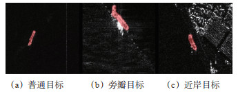
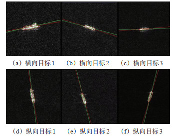
摘要: SAR图像中的船舶目标通常缺乏船舶身份属性,AIS数据与SAR影像在时间基准、空间位置和目标几何特征方面存在异构误差,导致复杂水域中SAR目标与AIS船舶身份关联容易出现错配,针对相关问题,研究了基于多维特征分步关联的SAR图像船舶身份识别方法。面向SAR影像与AIS数据融合过程中的时间异步、形态偏差和局部空间畸变等问题,建立了由AIS轨迹时间对齐、SAR船舶目标特征提取和多特征空间关联组成的处理流程。针对AIS船位离散且上报时间间隔不规则的特点,选取SAR成像时刻前后30min内的AIS轨迹数据,利用三次样条插值构建连续船舶运动轨迹,重采样获得与SAR成像时刻对应的船舶位置,从而减小船舶运动造成的时间匹配误差。针对SAR侧视成像、旁瓣效应,以及船体上层建筑强散射引起的船舶掩膜局部凸起与形态不对称问题,采用实例分割网络提取船舶像素级掩膜,并根据掩膜质心确定目标位置;利用主成分分析估计船舶主轴方向,设计迭代主轴修正方法,通过识别并逐步削弱非对称凸起区域对主方向估计的影响,获得相对稳定的船舶主轴、长度、宽度等几何特征。针对大范围SAR影像中不同区域存在偏移方向与偏移幅度差异的问题,将SAR目标与AIS目标转换至统一地理坐标系,利用迭代最近点算法完成全局粗配准,再依据目标空间分布采用k-means方法划分局部畸变区域,并将船舶长度与宽度的乘积作为尺度特征引入局部ICP匹配,在位置与尺度联合特征空间内完成分区域精确关联。采用上海吴淞口及长江入海口附近水域的实测SAR影像与AIS数据进行验证,实验数据包含1 171艘船舶的72 463条AIS记录。实例分割网络的精度、召回率和交并比阈值为0.5时的平均精度分别达到0.874、0.727、0.821。未经校准时,SAR目标与AIS目标之间的平均距离误差为2.469×10⁻³(°)(约274 m);采用本文方法进行关联校准后,平均距离误差降至0.368×10⁻³(°)(约41 m),较经典ICP、最近邻算法和匈牙利算法分别降低74.7%、77.2%、77.8%。实验结果表明,本文方法能够综合利用AIS轨迹信息、SAR船舶位置特征和目标尺度特征,同时缓解AIS时间异步、SAR船舶形态偏差,以及大范围影像局部非均匀几何畸变对身份关联结果的影响,在船舶密集、目标间距离较近且局部定位偏差方向不一致的复杂水域场景中具有较好的适用性。Abstract: To address the lack of identity attributes for ship targets in synthetic aperture radar (SAR) imagery and the heterogeneous temporal, spatial, and geometric errors between SAR imagery and automatic identification system (AIS) data, a multi-dimensional feature-based stepwise association method is proposed for ship identity identification in SAR imagery. The method is designed to mitigate temporal asynchrony, ship-shape deviation, and locally non-uniform spatial distortion during SAR AIS data fusion. AIS observations within 30 min before and after SAR imaging are used to construct continuous ship trajectories through cubic spline interpolation, and the ship positions corresponding to the SAR imaging time are reconstructed to reduce motion-induced temporal matching errors. An instance segmentation network is used to extract pixel-level ship masks and determine target positions from mask centroids. To address local protrusions and asymmetric shapes caused by side-looking imaging, sidelobe effects, and strong scattering from ship superstructures, principal component analysis (PCA) is employed to estimate the ship principal axis, and an iterative principal-axis correction method is developed to reduce the influence of asymmetric protrusion regions on orientation estimation. The corrected ship principal axis, length, and width are then used as geometric features. After SAR and AIS targets are transformed into a common geographic coordinate system, iterative closest point (ICP) is applied for global coarse registration. K-means is subsequently used to partition the scene into locally distorted regions according to the spatial distribution of targets, while the product of ship length and width is introduced as a scale feature for regional ICP matching. Accurate association is finally performed in a joint position scale feature space. Experiments are conducted using real SAR imagery and AIS data collected in the Wusongkou and Yangtze River estuary waters of Shanghai, including 72 463 AIS records from 1 171 vessels. The instance segmentation network achieves a precision of 0.874, a recall of 0.727, and a mean average precision at an intersection over union threshold of 0.5 (mAP50) of 0.821. The average distance error between SAR and AIS targets decreases from 2.469×10⁻³(°) before calibration to 0.368×10⁻³(°) after applying the proposed method, corresponding to reductions of 74.7%, 77.2%, and 77.8% compared with conventional ICP, nearest-neighbor matching, and the Hungarian algorithm, respectively. The results demonstrate that the proposed method can jointly exploit AIS trajectory information, SAR target positions, and ship-scale features while mitigating the effects of AIS temporal asynchrony, SAR ship-shape deviation, and locally non-uniform geometric distortion over large-area imagery. The method is particularly suitable for complex waters characterized by dense ship traffic, closely spaced targets, and spatially varying positioning errors, and can provide technical support for ship identity assignment in SAR imagery, maritime traffic supervision, abnormal-target screening, and multi-source maritime situational awareness in emergency search and rescue.
-

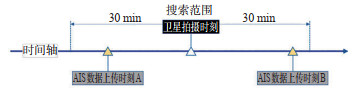
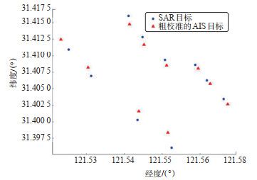
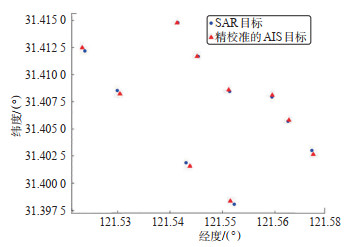
图 2 AIS数据与SAR图像时空差异
Figure 2. Schematic diagram of AIS data and SAR spatio-temporal differences

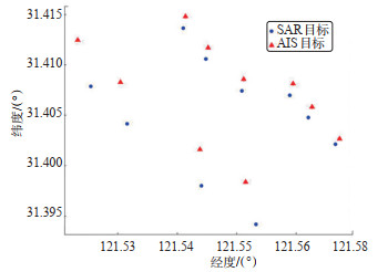
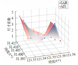
图 16 船舶目标三维特征空间展示
Figure 16. Visualization of three-dimensional feature space for ship targets
表 1 实例分割网络训练参数
Table 1. Instance segmentation network training parameters
超参数 参数值 迭代次数(epoch) 100 动量(momentum) 0.937 权重衰减(weight_decay) 0.0005 掩膜比例(mask_ratio) 4 批量尺寸(batch_size) 8 学习率(learning_rate) 0.01  下载: 导出CSV
表 2 实例分割网络在数据集中的表现
Table 2. The performance of the instance segmentation network on the dataset
实例数 精度 召回率 mAP50 mAP50-95 2 931 0.874 0.727 0.821 0.452
下载: 导出CSV
表 3 不同匹配方法的平均距离误差对比
Table 3. Comparison of average distance error of different matching methods
方法 平均距离误差/×10-3(°) 无匹配 2.469 NN 1.617 匈牙利算法 1.661 ICP 1.455 本文方法 0.368
下载: 导出CSV
-
[1] CHEN D, HUANG C, FAN T, et al. Predictive modelling for vessel traffic flow: a comprehensive survey from statistics to AI[J]. Transportation Safety and Environment, 2025, 7(3): 1-21. [2] LIU J, YU H, HUANG A, et al. Concepts, key technologies, applications and development trends in autonomous transportation systems[J]. Autonomous Transportation Research, 2025, 1(1): 1-23. doi: 10.1016/j.atres.2025.12.002 [3] ZHANG D, TAO J, WAN C, et al. Resilience analysis of maritime transportation networks: a systematic review[J]. Transportation Safety and Environment, 2024, 6(4): 1-13. [4] SARTONI M, GHIGLIONE M, PATRONE D, et al. Tip & cue AIS-assisted Gaussian process regression for ship dynamics modeling and cognitive SAR tasking[C]. 2025 European Data Handling & Data Processing Conference (EDH-PC), Elche, Spain: IEEE, 2025. [5] 周雪珂, 刘畅, 周滨. 多尺度特征融合与特征通道关系校准的SAR图像船舶检测[J]. 雷达学报, 2021, 10(4): 531-543.ZHOU X K, LIU C, ZHOU B. SAR image ship detection based on multi-scale feature fusion and feature channel relationship calibration[J]. Journal of Radars, 2021, 10(4): 531-543. (in Chinese) [6] 林鑫伟, 徐志京, 黄海. 复杂背景下的SAR图像多尺度舰船检测[J]. 中国航海, 2023, 46(2): 17-24, 32.LIN X W, XU Z J, HUANG H. Multi-scale detection of ship target against complex background out of SAR image[J]. Navigation of China, 2023, 46(2): 17-24, 32. (in Chinese) [7] PELICH R, CHINI M, HOSTACHE R, et al. Large-scale automatic vessel monitoring based on dual-polarization Sentinel-1 and AIS data[J]. Remote Sensing, 2019, 11(9): 1078. doi: 10.3390/rs11091078 [8] HUANG Z S, HU Q Y, MEI Q, et al. Identity recognition on waterways: a novel ship information tracking method based on multimodal data[J]. Journal of Navigation, 2021, 74(6): 1336-1352. doi: 10.1017/S0373463321000503 [9] 王永兴, 王涛, 韦扬. 多源融合的船舶身份智能识别与验证技术[J]. 中国航海, 2024, 45(4): 133-139.WANG Y X, WANG T, WEI Y. Intelligent identification and verification technology of ship identity based on multi-source fusion[J]. Navigation of China, 2024, 45(4): 133-139. (in Chinese) [10] 苏俊杰, 兰培真. 基于层次注意力孪生网络的船舶身份甄别[J]. 大连海事大学学报, 2022, 48(2): 31-39.SU J J, LAN P Z. Ship identity recognition based on hierarchical attention Siamese network[J]. Journal of Dalian Mari- time University, 2022, 48(2): 31-39. (in Chinese) [11] 白响恩, 方明权, 徐笑锋, 等. 复杂环境下的窄口段水域AIS轨迹重塑方法研究[J]. 中国航海, 2024, 47(3): 106-113.BAI X E, FANG M Q, XU X F, et al. Research on ship AIS trajectory reconstruction for narrow-mouth section waters under complex environment[J]. Navigation of China, 2024, 47(3): 106-113. (in Chinese) [12] GUO Y, LIU R W, QU J, et al. Asynchronous trajectory matching-based multimodal maritime data fusion for vessel traffic surveillance in inland waterways[J]. IEEE Transactions on Intelligent Transportation Systems, 2023, 24(11): 12779-12792. doi: 10.1109/TITS.2023.3285415 [13] 余红楚, 郭正, 魏天明, 等. 基于多源异构信息的船舶碰撞事故防控知识图谱研究[J]. 交通信息与安全, 2025, 43(3): 10-23. doi: 10.3963/j.jssn.1674-4861.2025.03.002YU H C, GUO Z, WEI T M, et al. A knowledge graph of ship collision prevention and control based on multi-source heterogeneous information[J]. Journal of Transport Information and Safety, 2025, 43(3): 10-23. (in Chinese) doi: 10.3963/j.jssn.1674-4861.2025.03.002 [14] HOU X, AO W, SONG Q, et al. FUSAR-Ship: building a high-resolution SAR-AIS matchup dataset of Gaofen-3 for ship detection and recognition[J]. Science China Information Sciences, 2020, 63(4): 140303. doi: 10.1007/s11432-019-2772-5 [15] GRAZIANO M D, RENGA A, MOCCIA A. Integration of automatic identification system (AIS) data and single-channel synthetic aperture radar (SAR) images by SAR-based ship velocity estimation for maritime situational awareness[J]. Remote Sensing, 2019, 11(19): 2196. doi: 10.3390/rs11192196 [16] RODGER M B. Spaceborne SAR and AIS data fusion for dense shipping environments[D]. Guildford: University of Surrey, 2022. [17] LIU Z, XU J, LI J, et al. Moving ship optimal association for maritime surveillance: fusing AIS and Sentinel-2 data[J]. IEEE Transactions on Geoscience and Remote Sensing, 2022, 60: 1-18. [18] SONG J, KIM D J, LEE S, et al. Geometric positioning error mitigation of SAR image in ocean utilizing AIS information[J]. IEEE Geoscience and Remote Sensing Letters, 2023, 20: 1-5. [19] AI J, XUE W, ZHU Y, et al. AIS-PVT: long-time AIS data assisted pyramid vision transformer for sea-land segmentation in dual-polarization SAR imagery[J]. IEEE Transactions on Geoscience and Remote Sensing, 2024, 62: 1-12. [20] GALDELLI A, MANCINI A, FERRÀ C, et al. A synergic integration of AIS data and SAR imagery to monitor fisheries and detect suspicious activities[J]. Sensors, 2021, 21(8): 2756. doi: 10.3390/s21082756 [21] REGGIANNINI M, SALERNO E, BACCIU C, et al. Remote sensing for maritime traffic understanding[J]. Remote Sensing, 2024, 16(3): 557. doi: 10.3390/rs16030557 [22] LEE J, PARK Y, KIM K, et al. AIS Matcher: a precise matching method of SAR imagery and AIS vessel data for maritime object identification[J]. Korean Journal of Remote Sensing, 2025, 41(6): 1179-1187. doi: 10.7780/kjrs.2025.41.6.18 [23] 孙波, 曾炜, 许小伟, 等. K波段雷达与AIS融合的目标识别与跟踪技术研究[J]. 船海工程, 2025, 54(5): 41-48.SUN B, ZENG W, XU X W, et al. Research on ship tracking technology with K-band radar and AIS fusion[J]. Ship & Ocean Engineering, 2025, 54(5): 41-48. (in Chinese) [24] LI F, YU K, YUAN C, et al. Dark ship detection via optical and SAR collaboration: an improved multi-feature association method between remote sensing images and AIS data[J]. Remote Sensing, 2025, 17(13): 2201. doi: 10.3390/rs17132201 [25] BOLYA D, ZHOU C, XIAO F, et al. YOLACT++: better real-time instance segmentation[J]. IEEE Transactions on Pattern Analysis and Machine Intelligence, 2022, 44(2): 1108-1121. doi: 10.1109/TPAMI.2020.3014297 [26] LI P, WANG R, WANG Y, et al. Evaluation of the ICP algorithm in 3D point cloud registration[J]. IEEE Access, 2020(8): 68030-68048. doi: 10.1109/ACCESS.2020.2986470 [27] AHMED M, SERAJ R, ISLAM S M S. The k-means algorithm: a comprehensive survey and performance evaluation[J]. Electronics, 2020, 9(8): 1295. doi: 10.3390/electronics9081295 [28] WEI S, ZENG X, QU Q, et al. HRSID: a high-resolution SAR images dataset for ship detection and instance segmentation[J]. IEEE Access, 2020(8): 120234-120254 doi: 10.1109/ACCESS.2020.3005861 -


 点击查看大图
计量
- 文章访问数: 98
- HTML全文浏览量: 16
- PDF下载量: 0
- 被引次数: 0